The mapping systems used to create these wonderful "seascapes" are essentially a form of acoustic remote sensing. All the observations are made from a mobile platform (normally a surface ship). The oldest form of terrain mapping was terrestrial (on land) and essentially static. The observer was thus confident that he was stationary, at a know position, and level. All measurements made by the land surveyor from that location were easy to interpret. The marine surveyor, however never had that luxury. He was always observing from a moving platform (be it under oar, sail or power). The traditional measurements however (bearings from coastal or stellar coordinates, and lead lines) were so sparse that it rarely was a concern that the observations were imperfect (they almost never overlapped).
With the advent of aerial photogrammetry at about the time of the first World War, for the first time, continuous terrain measurements (of the land surface) could now be obtained. To solve for the resulting terrestrial terrain model, one had to back-calculate the location and orientation of the aircraft. This could be done by finding precisely defined common ground control points in the high resolution aerial photos. Also, because the speed of light (~300,000,000 m/s) is so much faster than the speed and roll rate of the aircraft, you could assume that the photo was made at a single instant of time and that the aircraft had a fixed orientation at that instant. Another simplification that is used in aerial photogrammetry is that all the light vectors are travelling in straight lines. That is the azimuth and depression angle of any target as viewed from the aircraft points directly at the target.
As satellite mapping systems came into being, they too shared many of the geometric properties that the airborne cameras did. This was because they too, used electromagnetic (EM) radiation and assumed that the atmosphere was a non-refracting medium (that is to say, rays of light/EM don't significantly curve in their path from target to sensor).
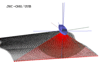
Multibeam sonar systems, however, (the marine acoustic remote sensing tool which features most prominently in this symposium) don't share the luxuries afforded to airborne or satellite systems. We are now using sound that travels far more slowly (typically ~1500m/s) and thus we can no longer assume that the position and orientation of the sensor (and the ship) where we "pinged" is the same as where we received the echo. The seafloor contains few easily identifiable targets (that we can resolve). And perhaps most unfortunately, the ocean water itself (the medium in which we make angle and range measurements) is highly variable in sound speed. A result of which is that our sound rays almost never travel in straight lines.
If we are going to end up with a faithful representation of the seabed terrain below us, we are going to have to precisely track the position, orientation and ray paths over the duration of every ping. For this we are going to need extra complementary instruments on our vessel that measure position, orientation and the sound speed structure below us. Such instruments exist with sufficient accuracy, but as we are going to find out, it is as much the integration of these instruments as their measurement accuracy that is the problem. For example, it is no use measuring the position of a GPS antenna to a centimetre if we can't then predict the position of the sonar relative to that antenna to that same accuracy.
None of these problems are insurmountable, but each one introduces imperfections in the resulting survey data. What I'd like to do is provide an overview of causes of these problems and help you understand how important each one is.
Timing
.
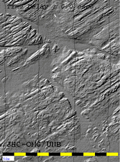
It is easiest to visualise what would happen if we used position fixes which had a time lag. The animation to the left shows the appearance of a seafloor as it is created by a series of parallel swaths (what we call the corridor of solutions collected on a single survey line). In this example you see the seafloor being shifted by the effect of +/- 2 seconds. What you notice is that within a single swath, the data retains its resolution. It is only the swath boundaries that are a problem. Each corridor gets shifted forward and back depending on the sign of the time offset. Any one of the images would seem reasonable (apart from a slight target offset in the overlap region the image looks o.k.), until you came back and surveyed the area again. When you calculate differences, it will appear that the rock ridges have moved.
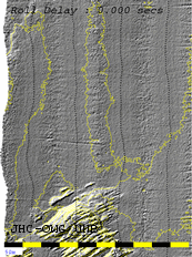
Another problem, however, that is more insidious is if the output of you motion sensor has a slight delay. For the animation to the right we see the effect go a +/-0.05 second delay on the roll sensor. In this case, we are using roll data that is out of date (by up to 50ms). As a result the profile we measure has a false tilt. The magnitude of the tilt depends on the rate at which the roll had been changing. At the top and the bottom of the roll curve, the roll is changing slowly, so the error is near zero. But when you are in the middle of a roll from one side to the other, the roll rate is maximum, and so is the error. Note that the roll error will be +ve or -ve depending on which way you are rolling at the time.
In this case, within a single swath the data starts to look corrupted. You see an across-track ribbing. You might even mistake it for natural features like sand waves (except you would be suspicous when they always align across the ship's track, wherever you go).
The big point to note here, is that, although the ribbing looks awful. It's magnitude is less than 1% of the depth. This is the highest standard required for normal hydrographic surveys.
Position
Today, the problem of position is generally the least of our worries,. Thanks to the US Department of Defense, we now have 24 hour coverage from a constellation of GPS satellites, worldwide. With care and using base stations to monitor small errors (the differential method) we should be able to get 2D positions at about the metre level. With extra hardware and over short baselines, an emerging method which "resolves the carrier phase" can even give us 3D solutions at the sub-decimetre scale.


Unfortunately a detailed static pre-survey is a luxury that is all too often denied to the operational surveyor. Due to cost considerations, a vessel may be chartered at short notice and the equipment installed on the vessel within just a few hours of the start of the survey. As a result, imperfections in the measurement of offset can show up in the final data. For example, if you don't allow for the fore-aft offset of the sonar from the heave sensor (which measures the motion of the ship going up and down with the waves) then as the vessel pitches, you won't correctly correct for the extra lever arm lifting the transducer up and down. The image to the left shows this graphically. To the right you see the effect of mismeasuring the athwartships offset distance. In this case any roll in the vessel will cause the sonar to go up and down moro go up and down more than you think.
In both cases you see an across track ribbing in the data. It seems rather like the roll time delay seen above, but you will notice that the whole swath goes up and down, not just the outer beams tilting back and forward. As with the roll ribbing shown in the timing example, the scale of the errors shown in the animations are all less than 1%, i.e. the data is within the usual specifications. (even if it still looks awful). For the purposes of fine scale mapping we need to be better than "spec.".
Other positioning problems are dominated by imperfectly knowing the height of the sonar above your reference level (usually a chart datum). The heave sensor monitors you going up and down with the waves, but can't tell if you slowly rise up by changing speed or burning off fuel. One of the most fundamental limitations is knowledge of the long period (hours) variation in the water level. Tides are the main influence. Whilst these are normally well constrained close to the coast, our estimate (normally a model rather than observations) in the offshore can be extremely poor. A detailed analysis of this is beyond the scope of this presentation, but suffice to say, each survey corridor (swath of data) will have slowly varying errors that result in poor swath to swath alignment.
Orientation
 Measuring the orientation (the roll, the pitch and the heading) of the ship
used to be one of the overriding problems. Pendulums work very well when
static but are useless on any platform that is experiencing accelerations.
Dynamic orientation can only be achieved through the proper use of inertial
sensors. This technology is not new but used to be almost exclusively used
within the military (as the costs were so high and the technology was in-part
classified). With the end of the cold war we are in a fortunate situation
that inertial technology has become cheaper and thus viable for use on commercial
marine platforms.
Measuring the orientation (the roll, the pitch and the heading) of the ship
used to be one of the overriding problems. Pendulums work very well when
static but are useless on any platform that is experiencing accelerations.
Dynamic orientation can only be achieved through the proper use of inertial
sensors. This technology is not new but used to be almost exclusively used
within the military (as the costs were so high and the technology was in-part
classified). With the end of the cold war we are in a fortunate situation
that inertial technology has become cheaper and thus viable for use on commercial
marine platforms.  They can now give us as good as 0.02 degrees accuracy. But as with the previous
examples, it isn't the accuracy of the sensor that is the problem. It mainly
depends on how well you can align the sensor with the sonar.
They can now give us as good as 0.02 degrees accuracy. But as with the previous
examples, it isn't the accuracy of the sensor that is the problem. It mainly
depends on how well you can align the sensor with the sonar.The example on the left shows the effect of a roll misalignment.
Basically, your swath corridors will always be tilted down to one side. As
you usually run alternate lines back and forth, any pair of lines will have
their overlapping boundaries moved either up or down together. You will notice
that the short wavelength detail in the image is well preserved (e.g. the
rock ridges). But should you resurvey this area using a different line direction
or with a different roll bias, the surfac differences will be dominated by
the mismatch due to the titled swaths.
To the right we now see an animation of the effect of a bad heading sensor. In this case, again, each swath on it's own looks fine. But the misalignment between the swaths is poor. You can see the detail, but you will get false changes when you compare this survey to a later one that are just due to false positions on the outermost beams due to a rotation.
To the right we now see an animation of the effect of a bad heading sensor. In this case, again, each swath on it's own looks fine. But the misalignment between the swaths is poor. You can see the detail, but you will get false changes when you compare this survey to a later one that are just due to false positions on the outermost beams due to a rotation.
 Whilst both of the examples above preserve the detail within a single swath,
you can get a dynamic error (much like the roll time delay or false lever
arms shown above) if you misalign you roll and pitch sensor by twisting it
in heading. Imagine you twist it 90 degrees. It will then record a roll when
the vessel pitches and vice-versa. But even if you misalign it in yaw just
a degree or two, you will get what is called "crosstalk". When the vessel
pitches, a small amount of that pitch rotation will be picked up by the slightly-misaligned
sensor and attributed to roll.
Whilst both of the examples above preserve the detail within a single swath,
you can get a dynamic error (much like the roll time delay or false lever
arms shown above) if you misalign you roll and pitch sensor by twisting it
in heading. Imagine you twist it 90 degrees. It will then record a roll when
the vessel pitches and vice-versa. But even if you misalign it in yaw just
a degree or two, you will get what is called "crosstalk". When the vessel
pitches, a small amount of that pitch rotation will be picked up by the slightly-misaligned
sensor and attributed to roll. The end result is that you see across track ribbing in the data that looks similar to a roll time delay (but is actually caused by a static yaw misalignment). Just as with the other two ribbing examples, the artifacts shown here, whilst they look terrible under sun-illumination, are actually less than 1% of the depth in height. i.e. the data are still in spec.
Refraction
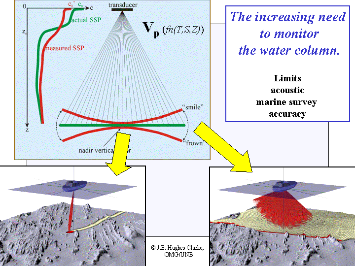 Even if we get our timing, position and orientation perfect, we still have
to cope with the path the sound takes through the ocean. In general the salinity
and temperature on the ocean change with depth. For mid-latitudes, the surface
waters are normally warmer (and thus sound speed faster) so there is a gradient
in sound speed. This gradient will cause sound energy to "refract". We need
to know how much. The effect gets worse as the ray becomes less vertical.
As long as we look straight down, the effect is minimal, but these new multibeam
systems that created all these "seascapes" work by looking out obliquely.
The more obliquely we can view, the wider the swath and the less shiptime
we need to use to cover the continental shelf.
Even if we get our timing, position and orientation perfect, we still have
to cope with the path the sound takes through the ocean. In general the salinity
and temperature on the ocean change with depth. For mid-latitudes, the surface
waters are normally warmer (and thus sound speed faster) so there is a gradient
in sound speed. This gradient will cause sound energy to "refract". We need
to know how much. The effect gets worse as the ray becomes less vertical.
As long as we look straight down, the effect is minimal, but these new multibeam
systems that created all these "seascapes" work by looking out obliquely.
The more obliquely we can view, the wider the swath and the less shiptime
we need to use to cover the continental shelf.  But if we don't measure the sound speed properly or more realistically,
the sound speed changes on us either in time or space. Then our outermost
solutions will tend to either curl up (a "smile") or down (a "frown"). The
effect of this is that each survey corridor will not match the one to either
side so well. What we will see is shiptrack-parallel ridges in out data.
The animation to the right shows the consequences of having a +/-5m/s error
somewhere in the water column.
But if we don't measure the sound speed properly or more realistically,
the sound speed changes on us either in time or space. Then our outermost
solutions will tend to either curl up (a "smile") or down (a "frown"). The
effect of this is that each survey corridor will not match the one to either
side so well. What we will see is shiptrack-parallel ridges in out data.
The animation to the right shows the consequences of having a +/-5m/s error
somewhere in the water column. The result is a distortion of the long wavelength topography, but you can still see the detail of the rock ridges (they are just curled up at the edges). Most of the "seascapes" presented in this symposium have this problem . All the Canadian outer-shelf data is corrupted by this simply because the watermass out on the outer shelf in mid-summer (when the surveys were run to get the best seastate) changes so rapidly.
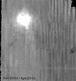
To illustrate how fast the watermass changes, the image below shows a cross section of the sound speed field under one of those multibeam survey vessels working on Georges Bank (~ 500 km SE of Boston) in mid summer. The data were collected using new technology that allows one to profile the sound speed every 2 minutes. Unfortunately this technology wasn't used for the whole survey. Typically a profile of sound speed was only taken at the end of each line which usually last about 1-3 hours (for example, imagine taking just the start and the end of this profile).
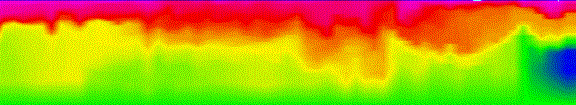
Cross section of the sound speed structure
on the edge of Georges Bank
(Colour range 10m/s, 45 km long profile from 0-100m)
 The example I've chosen is a dredge disposal site onto which thousands of
cubic metres of dredge spoil (the excess sand and mud removed from a harbour)
are deposited annually. This is a common activity at the mouths of most major
ports and harbours along both the east and west coasts of North America.
As the size and draught of commerical shipping has grown over the past 50
years, harbour approaches and docks, that used to be adequate are now too
shallow. The port authority has a simple choice, let the traffic move through
another, naturally deeper port (there are plenty of these to the north, but
they are further from the centres of population or industry) or actively
dredge.
The example I've chosen is a dredge disposal site onto which thousands of
cubic metres of dredge spoil (the excess sand and mud removed from a harbour)
are deposited annually. This is a common activity at the mouths of most major
ports and harbours along both the east and west coasts of North America.
As the size and draught of commerical shipping has grown over the past 50
years, harbour approaches and docks, that used to be adequate are now too
shallow. The port authority has a simple choice, let the traffic move through
another, naturally deeper port (there are plenty of these to the north, but
they are further from the centres of population or industry) or actively
dredge.This dredging is expensive and potentially an environmental issue. One is taking possibly slightly-contaminated sediments from the harbour floor (in the historic past, port-industries haven't always been so aware about the consequences of their processing by-products) and redistributing them in the deeper water off the harbour mouth.
We need to be sure that those dredge spoils don't remobilise excessively. But how?. The sand dumped tends to form underwater piles. But as the sand is unconsolidated (free to flow around), any current or wave activity is likely to redistribute it. To the left and above you see a series of 4 images, 6 months apart that show the seabed around an active dumpsite (collected by the Geological Survey of Canada). You can easily see the major changes (the area viewed is ~ 1.5 by 1.6 km and the depths range from 15-30m). To the right you see a surface difference map and it is immediately clear where they have been dumping. Nearly 3 metres of sand have built up in one place (the white bullseye).
But when that sand moves on from the dump location, it does so in thin sheets, 5-15 cm thick at most. Can we track those? Well if you look at the subtle detail in the difference map, you get a hint where there has been regional fine-scale erosion (the slightly darker areas) and deposition (the slightly lighter areas).
But notice the strong grain in the image from top to bottom. This is nothing to do with the seabed. The problem here is as the small survey vessel turns from one line to the other, it slows down and then speeds up . As it does so, the whole vessel sinks a few centimetres (rather like a speed boat lifts up as it goes onto the plane (only this vessel dosen't plane!)). Because we currently can't measure this properly it ends up as a residual in the data.
We are doing well with these new systems, way better
than we ever did before. But we could still do better....
In Summary
Pointing out all these limitations does seem rather pedantic (Hey, it's my job!). But, what are consequences of all of this to our interpretation of these extraordinary seascapes?
The First Pass.
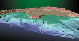
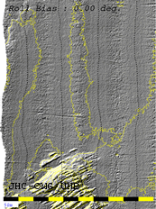
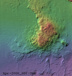
Well the first time we ever survey an area, we will see features at a scale that we've never resolved before. Already huge sections of the U.S. and Canadian continental shelf are being investigated at unprecedented scales. For example, take a look at the online images collected by the U.S. Geological Survey (e.g. image to the left) at:
Frankly, the fact that we don't quite put them in the right position at the decimetre scale has little effect on our initial interpretation. We are viewing detail that no other system has ever been capable of before. The temptation however, is to expect that, given that you can resolve a small scale feature once, you should be able to see whether it changed it's position or shape at a later time.
The Second Pass
The sedimented seafloor is a very dynamic interface. The waves, currents and the ebb and flow of the tide all result in subtle changes in the seabed over time. These changes can be accelerated or altered by the action of man. For example dredging harbours, damming off rivers (stopping sediments moving around) building breakwaters etc.. all will alter the natural processes by which the seafloor evolves. A disproportionate percentage of our population live right adjacent to our coastal seas. We are thus placing huge unnatural demands on those environments. We need to map and monitor, both the natural and anthropogenic changes of the seafloor so see what influence we have on our surrounding environment. One way to do this is through precise sea floor mapping, just as long as we can do it right.
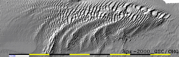 Just to show a taste of what we could potentially see, this last animation
shows a sand wave field, evolving naturally over time under the influence
of the tides in the Bay of Fundy. The data were collected over a period of
2 years by the Geological Survey of Canada.
Just to show a taste of what we could potentially see, this last animation
shows a sand wave field, evolving naturally over time under the influence
of the tides in the Bay of Fundy. The data were collected over a period of
2 years by the Geological Survey of Canada.