location map
Chart Geotiff
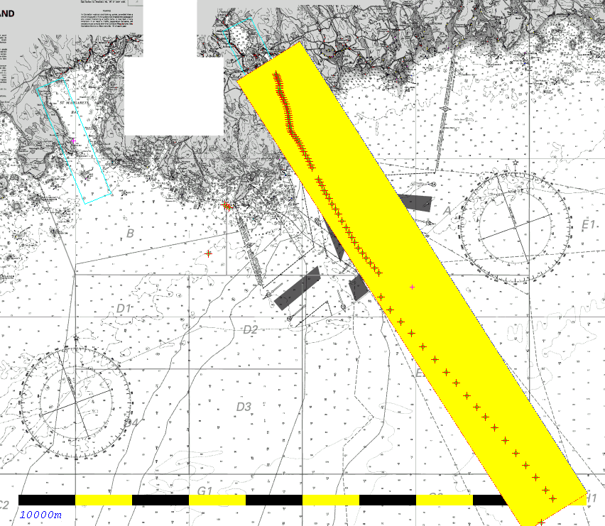
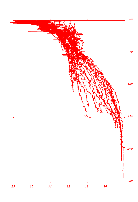
GGE5013 - 2007 - Oceanography Lab
CCGS Matthew - BOT-MVP200 Section

 Emerald Basin to
Halifax Harbour
11th June 2005

John E. Hughes Clarke
Ocean Mapping Group
University of New Brunswick

On the 11th of June 2005, the CCGS Matthew was in transit back from the Emerald Basin on the Central Scotian Shelf. It was operating an MVP-200 Oceanographic profiler. It recorded 89 oceangraphic profiles in a line from the deep water until the entrance of Halifax harbour.

As part of this lab, there are three steps:
  1. I'd like you to extract the raw data which you can obtain from - (gzipped tarball) and make a series of plots that describe the oceangraphic section (see explicit results below).
  2. Once you have plotted up the data, I'd like you to answer a series of questions at the end of this page concerning interpretation of the oceanography.
  3. Finally I'd like you to compare ray-trace solutions using the same TWTT and launch angle for a series of different profiles to establish the sensitivity of a multibeam system to these variation on sound speed.


AZMP sectionsThis is a mid-summer section along the inshore part of an oceanographic section (the "Halifax Line") that is routinely collected by the Bedford Institute of Oceanography several times a year. As a subset of this, a station (#2) in the inshore part is sampled bi-weekly. You can access the data through the DFO Marine Environmental Data Service, at:
            http://www.meds-sdmm.dfo-mpo.gc.ca/zmp/hydro/index_e.html

An overview of Oceanographic Conditions on the Scotian Shelf (including references for more details) can be found at:
        http://museum.gov.ns.ca/mnh/nature/nhns/t6/t6-1.pdf
        http://museum.gov.ns.ca/mnh/nature/nhns/t6/t6-2.pdf


The data look like this:

T Z plot temp
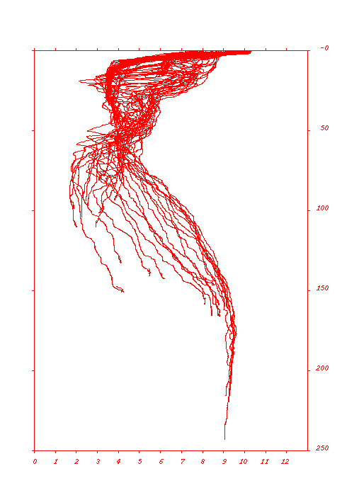
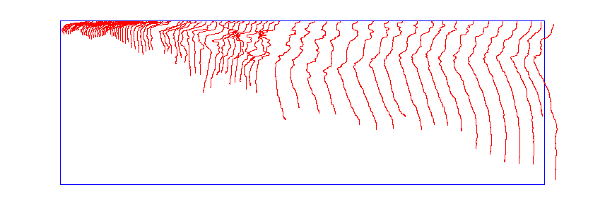
Temperature (grid - 20m vertically, 4000m horizontally , 1 degree contours) -stick plot
colorbar
11 deg
max

5 deg
middle

3 deg
min
T Z plot sali
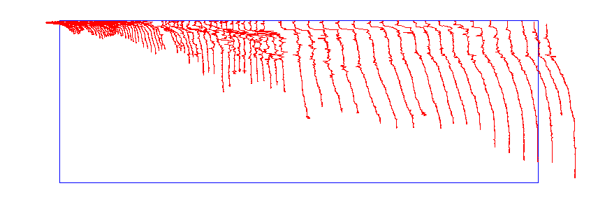
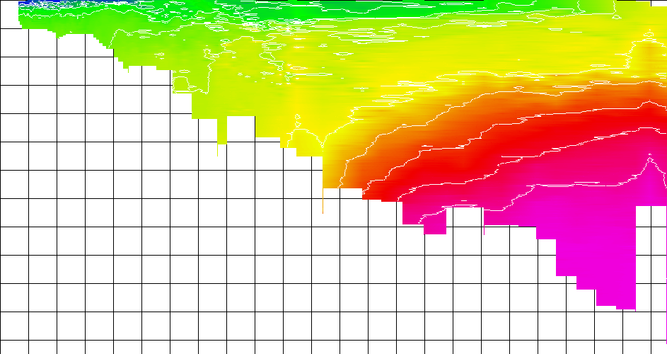
Salinity (grid - 20m vertically, 4000m horizontally , 0.5 ppt contours) - stick plot
colorbar 35 ppt
max

32.5 ppt
middle

29 ppt
min

Data Manipulation

The data will require extraction and reformatiing. This can be an onerous task.
To help out with manipulation, here is a peice of skeleton C code that reads in the mvp files: readMVP_skel.c


PC Time: 16:07:48
PC Date: 06-11-2005
GPS Position: $GPGGA,190405.00,4425.3952654,N,06339.7601234,W,2,07,1.7,3.03,M,,,3,0331*23
GPS Time:
Bottom Depth: 48.6
Ship Speed: 0.0
**********
Version: 2.21
Line Number: 00000
Instrument Type: 2, AML_CTD_Micro_Sensor
Serial Number: 4903
Press Offset: 0.0
AUX. Serial Sensors: 1
Number 5V Inputs: 1
Survey Latitude: 45.000
BOT F1: $GPGGA,190405.00,4425.3952654,N,06339.7601234,W,2,07,1.7,3.03,M,,,3,0331*23
BOT F2:
BOT F3:
BOT F4: $KMDPT,48.62,0.0,12000.0*4f
BOT F5:
BOT F6:
BOT F7:
BOT F8:
BOT F9:
BOT F10:
Ndecimate: 0
**********

P(dbar),C(mmho/cm),T(degC),Dpth(m),SV(m/s),S(PSS-78),Rho(kg/m^3),U1(mV)
   1.00,   32.088,   7.589,    0.99, 1475.91,   30.969, 1024.171, 0106.2
   0.90,   32.284,   7.583,    0.89, 1476.16,   31.184, 1024.341, 0106.2
   0.90,   32.204,   7.659,    0.89, 1476.26,   31.030, 1024.210, 0106.2
   0.90,   32.094,   7.797,    0.89, 1476.49,   30.791, 1024.003, 0106.2
   0.90,   32.028,   7.857,    0.89, 1476.57,   30.668, 1023.898, 0106.2
   0.90,   32.307,   7.827,    0.89, 1476.85,   30.991, 1024.155, 0106.2
   1.00,   32.409,   7.800,    0.99, 1476.92,   31.123, 1024.263, 0105.0

The files that end in "m1" are the ones you want. The exapmle to the left shows what the data format looks like. There are 89 profiles. They are obviously ASCII You can extract:

The time can be seen in Red. (note that the GPS time is in UTC whereas the PC Time (including date in in a sloppy local time)
The position can be seen in Blue.
The bottom depth can be seen in Brown

The profile data can be seen at the bottom.
You need to extract  the:
  • depth
  • salinity
  • temperature
  • density
  • sound velocity
  • milliVolts - (actualy a chlorophyll sensor I believe)

Processing Requirements:

Plot up the locations (see if you can find a suitable cartographic backdrop image)

Extract the data and make the following xcross-sectional plots:
Calculate :
8/25
QUESTIONS:

  1. What is an MVP-200 and what is its the capability?
    -references :
    http://alexherman.com/pdf/AlexHerman.com-The_Moving_Vessel_Profiler.pdf
    http://www.brooke-ocean.com/
2/25


Data Interpretation

Significance to the Oceanographic Environment

Explain the main oceanographic features visible in the profile.

I'll expand this with leading questions....

5/25

Annual reviews of the Measurements made along the Halifax Line and overviews of Scotian Shelf Oceanographic observations can be obtained from:

Consequences for Hydrographic Survey

Controls on Sound Speed Structure:

Compare and contrast the relative importance of temperature versus salinity in influencing the sound speed cross-section.
2/25

Estimating the Sensitivity of the refracted ray path to water column structure:

Pick 5 evenly spaced end-member Vp profiles ( in depths greater than 75m ) that are representative of the main watermasses seen.

Pick one and  do a ray trace for a beam (starting at a depth of 3m) with the following launch angles of 0, 30 50 65 & 70 degrees until you reach a depth of 75m.
Extract the TWTT to reach that depth for that profile for each of the angles (and record the across-track distance achieved).

For each of the other 4 profiles, using the same TWTT, see what depth and across-track distance you would achieve.
  1. What is the range of depth and across-track errors ?
  2. What does this mean in terms of IHO acceptance ?

8/25


page generated by JEHC on September 14th 2007 // Last updated by IanC on Sept 21, 2007