Matthew tracks
GGE5013 - 2007 - Marine Geology Lab
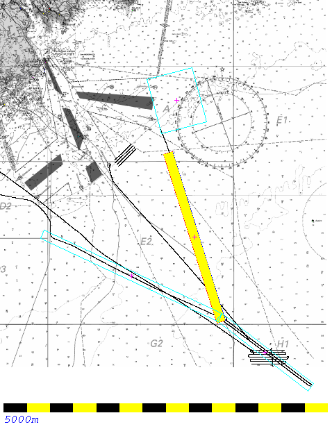
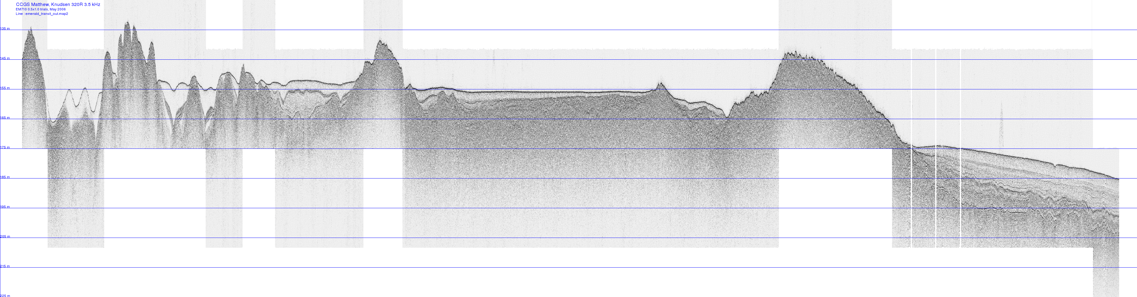
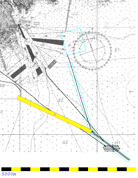
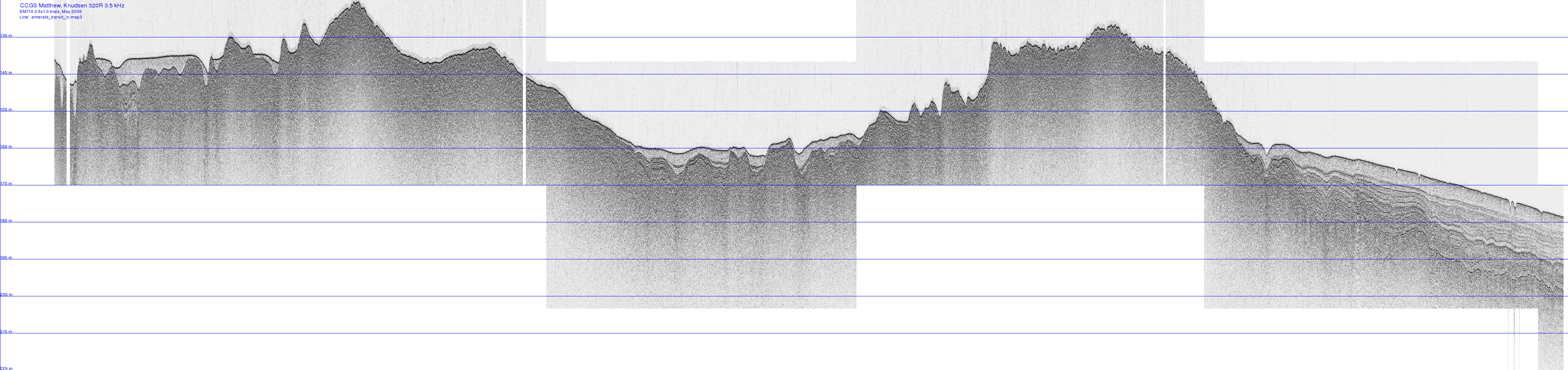
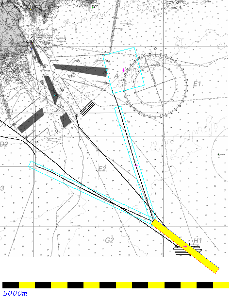
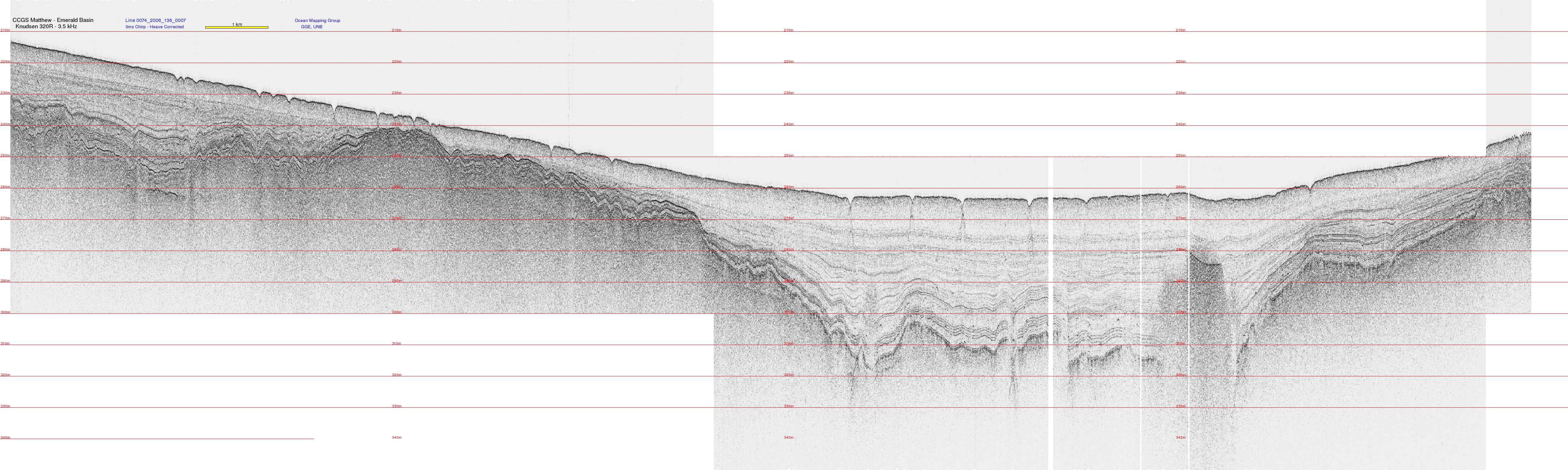
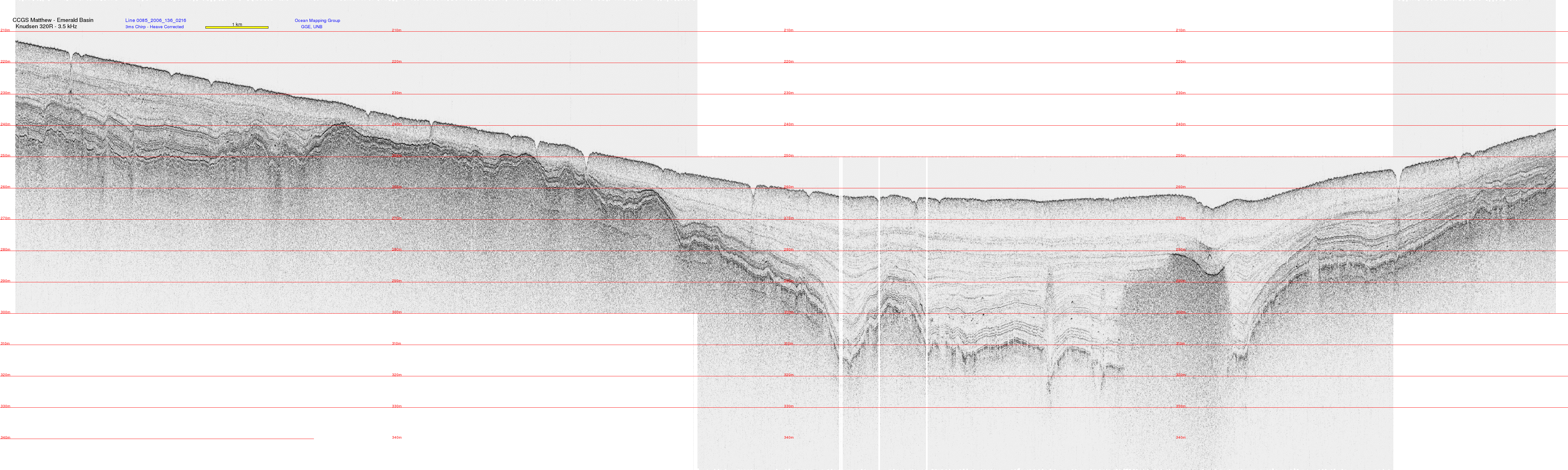
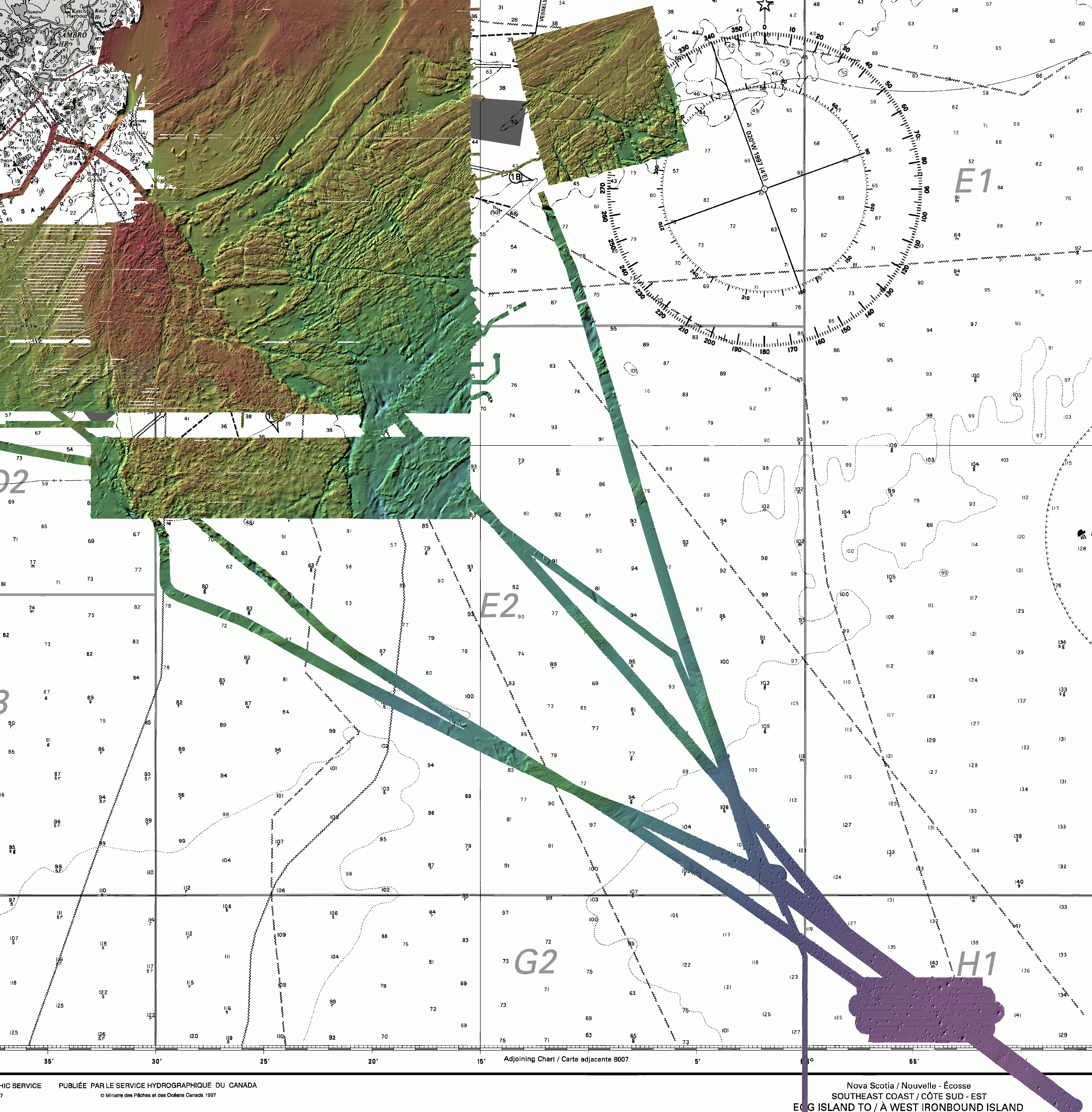
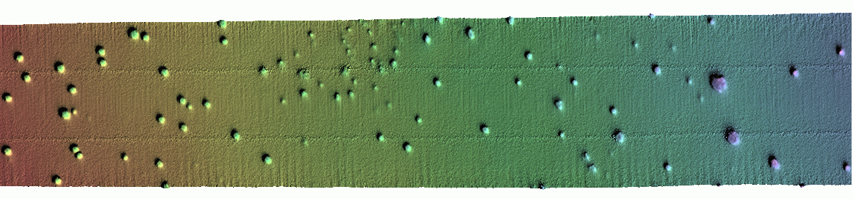
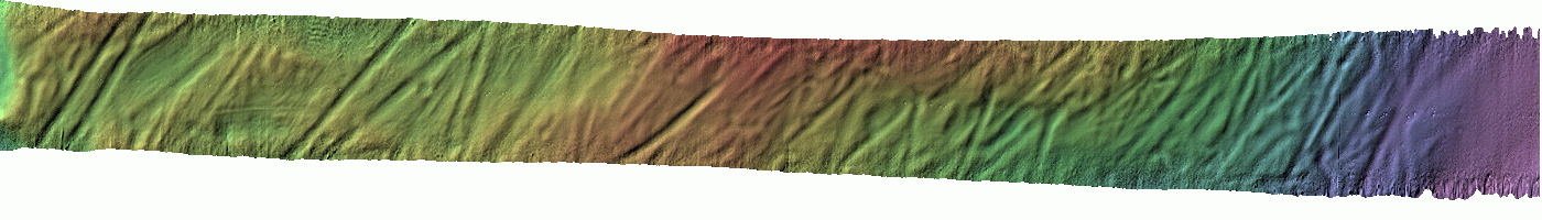
CCGS Matthew - EM710 multibeam and  3.5 kHz subbottom
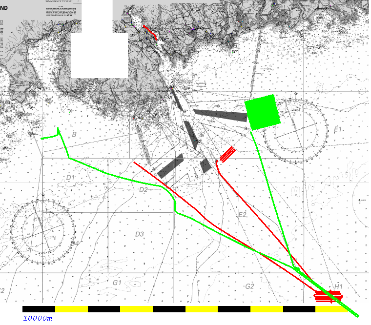
Chebucto Head to Emerald Basin
June 2005 and May 2006

John E. Hughes Clarke
Ocean Mapping Group
University of New Brunswick
In June 2005, the CCGS Matthew did the first acceptance trials of a 2x2 degree EM710. This included a transit to and from the Emerald Basin, the deepest point on the Scotian Shelf. In May of 2006 the trial was repeated when the EM710 was upgraded to a 0.5x1.0 degree system. At that time, the Geological Survey of Canada had installed a Knudsen 320R chirped 3.5 kHz subbottom profiler and this was tested in the same region.

These data represent 4 multibeam corridors and 2 subbottom profiles from the inner to the central Scotian Shelf. These data are used for this lab as an example of a typical high latitude (glaciated margin) corridor survey (whether for pipeline of cable route). The students are asked to interpret both the geology and the sonar system performances and then to extract specific engineering metrics from some of the geohazards along the route..


3.5 kHz Subbottom Data for Interpretation

location
outbound

EM710 bathymetry
5m contours
pink : 140m
blue : 220m

bathy
EM710 backscatter
white : -7.5dB
black : -35dB

backscatter
Oubound Transit Corridor - 38,200 m long, 2,000m wide 10m horizontal pixel
---------
location in bound
EM710 bathymetry
5m contours
pink : 140m
blue : 220m
bathy
EM710 backscatter
white : -7.5dB
black : -35dB
backscatter
Inbound Transit Corridor - 42,400 m long, 2,000m wide 10m horizontal pixel
---------
location emerald A
EM710 bathymetry
5m contours
pink : 210m
blue : 270m
bathy
EM710 backscatter
white : -7.5dB
black : -35dB
backscatter
1st section across Emerald Basin - 25,000 m long, 2,000m wide 10m horizontal pixel
location Emerald B
2nd section across Emerald Basin

Geological Background:
all MB
The figure to the left is a 10m resolution (click for full res.) image of all the multibeam collected in the area including the three transit corridors you have to study.

Explain the geology over which we are transiting, basing your interpretation on the three longitudinal sections of multibeam and subbottom provided above. Specifically:
  • what are the names of the main stratigraphic facies visibile in the subbottom.
  • describe how the surface morphology and backscatter relate to the subsurface sediment types.
  • What is the origin of the sediment in the regions where you see significant subbottom?
  • What is the origin of the linear features in the high backscatter region 2/3 of the way out to sea?.
  • What is the likely origin of the circular depressions seen in the Emerald Basin?
  • There is a region 3/4 of the way across the Emerald Basin seismic line where the deep penetration is abruptly terminated (just above the O of Ocean"). What do you think caused this?
  • Measure the deepest penetration in the Emerald Basin in two-way travel time from the seabed (All figures are made assuming 1500m/s). What is this distance in metres? What assumptions do you have to make?

A good overview of the Scotian Shelf quaternary geology can be found at : http://museum.gov.ns.ca/mnh/nature/nhns/t3/t3-5.htm
     in particular you may find this document useful:  http://museum.gov.ns.ca/mnh/nature/nhns/t3/t3-5.pdf
5/25

Assessing the multibeam data quality

Describe the main characterisitics of a Kongsberg EM710.

What potential data artifacts can you see?. Specifically  describe any:
5/25

Assessing the Capability of the Knudsen 3.5 kHz subbottom profiler.


5/25

Quantitative Analysis of Morphological Features

You are provided with two 5m grids of the seafloor:
Pockmarks
6000m x 1400m (1200 x 280 pixels)
pockmarks
the data can be downloaded as an ESRI binary grid file or an OMG binary file for analysis:
5/25

Grooves (can't say what they are- you are asked above!)
7000m x 100m (1400 x 200 pixels)
grooves

to help you get going here is a skeleton piece of code that will read the .r4 files. ... readDTM_skel.c

you should be able to compile it stand alone like this:
   > cc readDTM_skel.c -lm -o readDTM_skel

and run it like this to start with:
 extracting a cross section in pixels:
    > readDTM_skel -infile area5.fake.r4 -outfile temp.ascii -start 0 0 -end 1200 279

or trying to find the lows ....
    > readDTM_skel -infile area5.fake.r4 -outfile temp.ascii -find_lows -threshold 0.1 -offset 4

have fun modifying it....

5/25


Acknowledgements

These data were kindly made available through the following personnel:


last modified by JHC, October 2007