Contents:
Introduction
In 2010, oceanographic, hydrographic and geophysical data at Kennebecasis Bay was collected using the Ocean Mapping Group launch, CSL Heron. The oceanographic data was collected using a Moving Vessel Profiler (MVP); the water column and bathymetric data was collected with an EM710 Multi-beam echosounder; and the geophysical data was collected using a 3.5 kiloHertz (kHz) Knudsen 320 Sub-bottom profilers.
Oceanographic Survey
The survey region was divided into two areas (Area 1 & 2). Area 1 started at the mouth of Kennebecasis Bay and terminated at the end of the Bay. The MVP dips locations of this area are represented in green on the map. The last dip in this area is highlighted in red. This dip is considered as the starting point of Area 2, while the MVP dips in this Area are represented in blue.

Survey Area 1

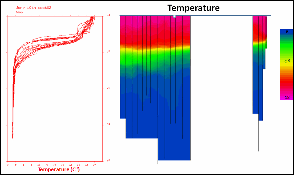
| Oceanographic Data |
Water Column |

|

|
Survey Area 2

| Oceanographic Data |
Water Column |
|

|
Geophysical Survey
In the Kennebecasis Bay, a series of buried landslides exist. Thus, the Ocean Mapping Group completed four days of a sub-bottom survey of Kennebecasis Bay to define the slides. The survey region was divided into three areas (Area 1, 2 & 3).
Seismic Sub-bottom Profile Survey Area 1
Area 1 represents the entire Kennebecasis Bay and contains three sub-bottom lines. The first line (line 1) started at the mouth of the Kennebecasis and ended approximately at the middle of the bay. The second line (line 2) started from the end of the first line and finished at the end of the bay. The third line (line 3) is the one collected when we returned from the other direction of the bay.
Seismic Sub-bottom Profile Survey Area 2 & 3
Area 2 contains six sub-bottom lines, while Area 3 contains 13 sub-bottom lines. The following animations show the series of sub-bottom profiles obtained over Areas 2 and 3. In these animations, each sub-bottom line is presented with the multi-beam coverage of each area. The navigation of the sub-bottom lines will show on top of the multi-beam coverage.
Seismic Sub-bottom Profile Survey Area 2
Seismic Sub-bottom Profile Survey Area 3
Created by Majed Almehmad, May 2012


