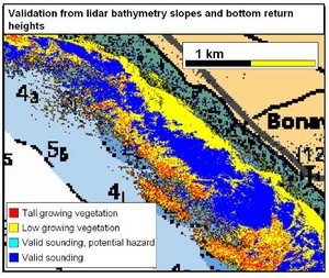
Validate SHOALS Soundings
In our dataset collected in Baie des Chaleurs, we noticed that the green laser was often tracking on the vegetation. In order to
indentify weed tracking this program was developed. It compares the optical backscatter and the local batymetric slopes. In this
way we can segment tall or low growing vegetation. The program can also be used in combination with acoustical backscatter. In that case,
vegetated rock or sand is indentified.
The program takes a 8bit image file, optical backscatter and slopes, or optical backscatter and acoustical backscatter.
validateSHOALS -reference file -reference_threshold floatingpoint# -height file -reference_threshold floatingpoint# -out file
The reference file is the slope file or the acoustical backscatter file. Height refers to the optical backscatter file.
Use '-bs' option when for acoustical backscatter is used as reference.
Back
__________________________
Last modified: 2-9-08 Pim.
~