Options for Nuliajuk Operations in October 2012
John E. Hughes Clarke, James Muggah and Travis Hamilton, OMG, UNB


OMG staff will be on board the MV Nuliajuk for ~ the month of October (starting whenever the turbot/shark program ends in Clyde River). The ArcticNet objectives of the  program are described below, but at this point, time allocations for other mapping targets desired by GN have yet to be defined. This web page is designed to promote discussion on possible options (all being weather and ice limited anyway).

Anet targets
ArcticNet Seabed Mapping Targets:

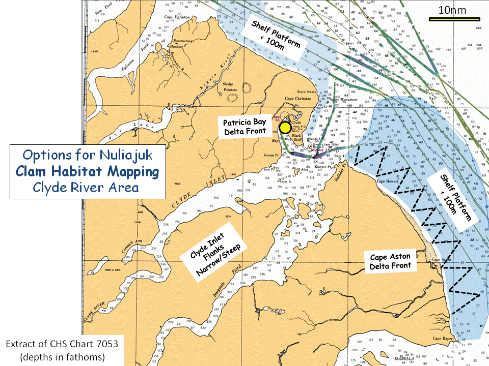
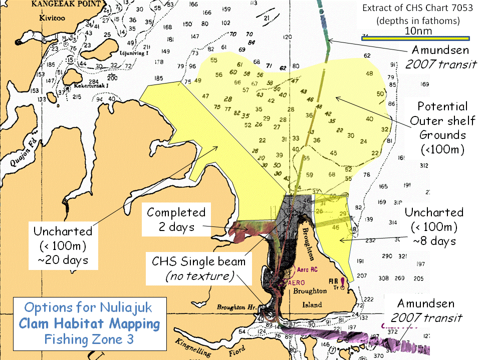
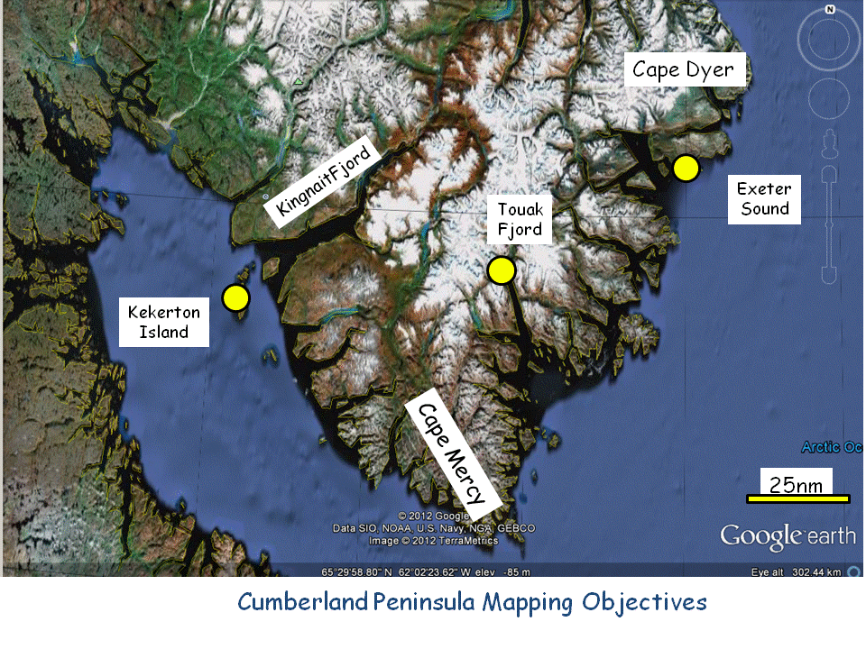
At this time, the ArcticNet funding is assumed to cover ~ 10 mapping days of Nuliajuk time off Baffin Island. The map to the left indicates the target locations. For each location, the prime aim is to look for submerged terraces in areas of rapid sedimentation. For most locations, a single 12 hour mapping day is considered to be sufficient. For the Iqaluit harbour area, 2 mapping days are implemented. This provided a total of 8 planned  mapping days. Two extra days are held in reserve to expand any one of the target areas as desired by the staff on board.

Depending on whether inter-target transits are done in daylight only, or while steaming overnight (will the 5th crew member be on board for that?), the transit time between  these will vary. A total of about 850nm need to be covered to get from Clyde to Iqaluit. This is ideally ~ 120 hours at 7 knots (~5 24 hour days). If only 12 hour days are utilized (anchoring overnight) then 10 transit days are needed. 
So assuming that we start on 1st October (??) then the vessel should be ready to leave Iqaluit by the 20th. From there, it is another ~ 800nm (4-5 days straight?) steam to Goose Bay to complete the mapping work there.

Along the transits, multibeam data will be collected, but it is not clear if there are any objectives that GN would like to have met. We will be steaming past several areas that they have expressed an interest in, including:
While these options have been mentioned, no concrete times have been allocated. The follow figures illustrate :

Clyde River - Cape Aston Foreland:
Requirements:

clyde options
The map to the left show what (little) we know about the bathymetry in the Clyde area. South of Cape Christian (just north of Clyde River) there has never been a systematic charting program (no communities, no DEW stations). Almost all the data on the chart consists of transit tracks. ArcticNet CCGS Amundsen multibeam corrdors are superimposed.

While GN have expressed a desire to map clam habitat in the Clyde area, at this time there are no specified areas or times allocated. Based on Siferd's work around Qik (see discussion below), sedimented areas in the 20-100m depth range are optimal habitats for Mya. His work also indicates that steep fjord flanks have lower densities than gradually sloping regions. Based on that, the optimal areas around Clyde would appear to be the extensive shallow inner shelves north and south of the trough extending out of Clyde Inlet (areas shaded blue in figure). Praeg et al. (2007, GSC OF-5409) describe the "Cape Aston Sand" unit which is expressed as flat muddy sand sheets. Depending on how extensive these are inshore (the GSC operations didn't get much closer than 10miles from the coast), they could represent extensive habitats.

As a recommendation, and as the vessel is transiting south anyway, I'd propose a zig zag series of tracks (see figure). The areas involved are huge and as the depths are shallow, the swath widths will be tiny, so such a reconnaissance investigation would allow us to assess the region reasonably rapidly. Lines should extend inshore to the ~10m contour (or wherever Cecil feels it prudent to go), and then offshore until the 100m contour.


Qikiqtarjuaq :
Requirements:
Merchant's Bay:
Requirements:

clam zones
The image to the left was provided by Tim Siferd to indicate the defined fishing zones along the eastern Baffin coastline. The only existing clam density surveys are in zone 3  (Broughton Island vicinity) as well as a few dive sites in zone 1 (Merchant's Bay).

We would  suggest, when transiting south from Clyde,  that the Nuliajuk should steam through the zones, (within reasonably charted areas) seeking depths less than 100m to get a baseline of likely bottom types in these regions.

On arrival at Qik we would suggest focussing systematic clam habitat surveys on just two areas:
  1. Zone 3 NW of Broughton Harbour.
  2. Zone 1 NW flank of Merchant's Bay.
Depending on how much time GN would like to allocate to these projects, the figures below outline potential areas based on Siferd's work to date.

foreland shoals
The figure to the left illustrates what little is known about the continental shelf off Eastern Baffin Island (other than DEW station corridors, there has never been a systematic charting program in this region). The area within the dashed black lines is approximately the extent of the Fishing Zones defined in the previous figure.
As well as the coastal strips, shelf areas less than 50 fathoms (~ 100m) are potential clam habitat sites. The shelf consists of a series of surprisingly shallow plateaus (indicated as areas A, B, C and D) between glacial scoured troughs (100-300 fathoms deep) that extend across the shelf. The inner sections of these plateaus can be extremely shallow (<10 fathoms occasionally reported, routinely less than 20 fathoms). Such vast areas, although poorly charted could represent clam habitat.
While current diver-supported clamming operations would probably be restricted to coastal areas, should a dredging/dragging program be investigated, these areas are far more expansive than the coastal strips. The areas, however, are very extensive and would need months of ship time to reasonably map. A transit corridor, as the vessel steams south would allow us to begin to assess what sort of seafloor sediments and morphology are present on these foreland plateaus.

As a suggestion, focusing a few GN days to extend the August Nuliajuk work in area C would be profitable. And given that ArcticNet will be entering Merchant's Bay anyway, a few GN days there (area D) would make sense? Details are provided below.

Mya Density
The figure to the left was compiled from : Siferd, T.D. 2005. Assessment of a clam fishery near Qikiqtarjuaq, Nunavut. Can.Tech. Rep. Fish. Aquat. Sci. ####: vi+ ## p. combining his figure 8 and 19.

It illustrates the Mya Truncata population densities as a function of depth for the 9 subregions he investigated. As can clearly be seen, the North Baffin Island and North and South Broughton Harbour regions have the highest densities. In all cases the densities increase with depth. The maximum depth of observation was 40m.
Siferd  indicates that:
 Mya can be found from the freeze out area to over 100m but the main densities are at about 20m with near zeros at the upper and lower end of the 100m distribution.

The much poorer densities obtained in the steeper Fjord and Island flanks suggests that these are less favourable (possibly because they are generally coarser sediments?).

Based on this, we're (wildly) speculating that mapping would be most productive on lower gradient regions less than ~ 100m.


qik clam mapping
The image to the left illustrates the lower relief region less than ~ 100m (yellow shading) to the north of Qik. To the south, as you enter the national park, the area is dominated by fjords and strong topography. As stated above, based on Siferd's work, it would appear that the more low gradient regions are favoured for clam habitat.  Also if dragging operations are to be conducted, the fjord flanks represent just narrow strips rather than larger expansive areas that would be more efficient to work over.

Based on that, two potential areas are proposed to start expanding the habitat mapping work beyond the 2 day coverage already obtained in August.

A - coastal corridor extending from Qik to Kivitoo. This all lies inshore of previously charted areas (a corridor established by USCGS Bramble in 1958). This coastal strip will probably be mainly < 100m. There might be two deeper troughs extending seaward of the small fjords. The area is within small boat access range of Qik.  Mapping this would provide new information  both for habitat and for shipping. While the whole area would require ~20 days of operations, with a few days ,a corridor could be built through it to assess what is there.

B - coastal corridor NE of Broughton Island. The CHS coverage stops west of the northern tip of the island. Rare transit lines indicate that there is a relatively wide shelf that extends to the NE. This area is within range of small boat access from Qik and again mapping would provide both for habitat and for shipping.


Qik to date
The map to the left shows:
  • extent of pre-exisiting CHS single beam bathymetry (50m line spacing)
  • EM3002 mapping conducted by MV Nuliajuk in August 2012
  • the one multibeam transit corridor collected by the Amundsen in 2007
 Higher resolution maps of the Nuliajuk coverage  (NW area and Dock area) are available at the bottom of this report.

Based on a request from Wayne, we did the proposed dock site. And based on a recommendation by Devin Imrie, we did the area to the NW of the harbour (as it was outside the no fishing zone). As can be seen there is distinct patchiness to the backscatter data indicating significant variations in bottom type (from mud to gravel). It will be interesting to plot Siferd's results in this area to see what correlations exist.

I would propose building on this survey to the north and west (option A above), seeking waters less than 100m along the coast towards Kivitoo.


Merchant's Bay options
The discussion above focuses on fishing zone 3 (close to Qik). The only other observations made by Siferd are from dives within Merchant's Bay. This is an area that Bell/Forbes (ArcticNet) want to spend 2 days anyway.

The map to the left shows potential targets to the SE of Broughton Island in the Merchant's Bay vicinity.
Siferd (in emails to me) noted that:
"other areas such as Merchants Bay are more promising in terms of size and number of clams than Broughton"

"We only dove in Merchant's Bay but unfortunately did not get back there with the camera for a proper survey.  The bay had the largest clams I have seen in the arctic and appeared to be quite dense.  The two site we dove were off the outpost camp nearer the mouth and the river to the west of the camp further into the bay.  Both were good areas of sand flats which should be good for dredging.  The approximate coordinates were, 67°10'N 63°01'W and 67°06.5'N 63°18'W respectively." 

To meet GN requirements, I'd suggest dedicating a couple of days to working around Siferd's dive sites on the NW flank of the Bay.

South East Cumberland Peninsula ArcticNet Mapping Targets
Cumberland Peninsula
Two delta/beach front areas are targets for Arcticnet:
  1. Mouth of Exeter Sound (Forbes Bell - 1 mapping day).
  2. Head of Touak Fjord (Forbes/Bell - 1 mapping day)
At this point there are no ArcticNet plans to reenter Cumberland Sound.  Is there a GN desire to do any work there?:
  • Kekerton Harbour approaches?.
  • Kingnait Fjord corridor?.


 Frobisher Bay

After that the plan is to transit directly to Iqaluit for GN unloading of equipment and :


Goose Bay/Lake Melville

The Nuliajuk successfully completed ~ 10(?) days of mapping in Lake Melville. Depending how you do the math, there are several more days of mapping to complete. Do we plan to undertake those on the way south or will they be carried over to 2013 operations?


EXAMPLE EM3002 MULTIBEAM MAPPING RESULTS

NW Clam Habitat Map Area
The imagery below indicate the quality of the seabed bathymetry and backscatter data obtained from the MV Nuliajuk EM3002 multibeam system, acquired NW of Qikitarjuaq harbour in August. The survey was undertaken in a 2 day window. For reference, the available CHS survey data is shown. The survey was deliberately located just outside the existing surveyed area. Thus the area covered had never been charted. For reference the single beam sounding lines to the east were spaced 50m apart.

august em3002 bathymetry
Nuliajuk EM3002 bathymetry, JD 225 and 226 (August 12th 13th) 2012
Depth range, 7m to 137m. 10m contouring in white, 50m contouring in black. (click for 1m resolution imagery)
august em3002 backscatter
Nuliajuk EM3002 backscatter, JD 225 and 226 (August 12th 13th) 2012
Greyscale Range - Black -35 dB, White, -10dB 10m contouring in white, 50m contouring in black. (click for 1m resolution imagery)


Docksite Survey:
The following images link to 50cm resolution maps of the docksite.
dock bathy
dock BS
 Proposed Qikitarjuaq docksite
approximate proposed dock location indicated
EM3002 Bathymetry (click for 50cm imagery)
10m contour in white, 50 contour in black
*referenced to Mean Sea Level, CHS contours to Chart Datum
 Proposed Qikitarjuaq docksite
approximate proposed dock location indicated
EM3002 Backscatter (click for 50cm imagery)
Greyscale Range - Black -35 dB, White, -10dB
10m contour in white, 50 contour in black
*referenced to Mean Sea Level, CHS contours to Chart Datum


page developed by JEHC, September 2012.