back to
Project
Index

Piscataqua Mouth Estuarine Circulation Study
ADCP - EM2040-WCD Transects
January 06th
RV Gulf Surveyor January 2021

John E. Hughes Clarke and Indra Prasetyawan
EM2040 and ADCP ops
Matt Rowell and Dan Tauriello
RVGS Operations
Class of ESCI 896.02 (2021)
Applied Physical Oceanography
for Hydrographic Surveyors


January
06th

2021

notes
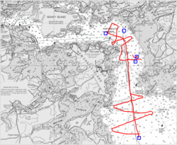
map
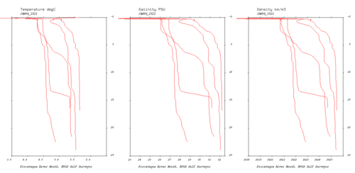
all CTD dips in the day
(relative to Fort Point tides)
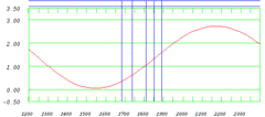
tide

dips


depth average current vectors
(flow from yellow to black)

vector map
 jan06_2021_114.ens.bt
tide
acquisition window relative to
local tides at Fort Point


vertical section
just to show what ENS retains compared ot ENX.
depth average current vectors
(flow from yellow to black)

vector map
 jan06_2021_114.enx.bt
tide
acquisition window relative to
local tides at Fort Point


vertical section
First line with 0.25 bins just to show what NOT to do.


ctd dip
dip
 CTD Dip: 025485_2021-01-06_16-49-56
---.
depth average current vectors
(flow from yellow to black)

vector map
 jan06_2021_115.ens.bt
tide
acquisition window relative to
local tides at Fort Point


vertical section
just to show what ENS retains compared to ENX
depth average current vectors
(flow from yellow to black)

vector map
 jan06_2021_115.enx.bt
tide
acquisition window relative to
local tides at Fort Point


vertical section
0.25m bin size.


depth average current vectors
(flow from yellow to black)

vector map
 jan06_2021_116.enx.bt
tide
acquisition window relative to
local tides at Fort Point


vertical section
0.5m bin size.


depth average current vectors
(flow from yellow to black)

vector map
 jan06_2021_117.enx.bt
tide
acquisition window relative to
local tides at Fort Point


vertical section
1m bin size.


depth average current vectors
(flow from yellow to black)

vector map
 jan06_2021_118.enx.bt
tide
acquisition window relative to
local tides at Fort Point


vertical section
2m bin size.


depth average current vectors
(flow from yellow to black)

vector map
 jan06_2021_120.enx.bt
tide
acquisition window relative to
local tides at Fort Point


vertical section
words and comments.


ctd dip
dip
 CTD Dip: 025485_2021-01-06_17-21-47
---.
depth average current vectors
(flow from yellow to black)

vector map
 jan06_2021_121.enx.bt
tide
acquisition window relative to
local tides at Fort Point


vertical section
words and comments.


depth average current vectors
(flow from yellow to black)

vector map
 jan06_2021_122.enx.bt
tide
acquisition window relative to
local tides at Fort Point


vertical section
words and comments.


depth average current vectors
(flow from yellow to black)

vector map
 jan06_2021_123.enx.bt
tide
acquisition window relative to
local tides at Fort Point


vertical section
words and comments.


depth average current vectors
(flow from yellow to black)

vector map
 jan06_2021_124.enx.bt
tide
acquisition window relative to
local tides at Fort Point


vertical section
words and comments.
vector map
0000_20210106_174113
tide
vertical
                  section
upper: 0-25m water column imagery
lower: seabed backscatter corridor

MB wcd thoughts....


depth average current vectors
(flow from yellow to black)

vector map
 jan06_2021_125.enx.bt
tide
acquisition window relative to
local tides at Fort Point


vertical section
words and comments.
vector map
0001_20210106_174300
tide
vertical
                  section
upper: 0-25m water column imagery
lower: seabed backscatter corridor

MB wcd thoughts....


depth average current vectors
(flow from yellow to black)

vector map
 jan06_2021_126.enx.bt
tide
acquisition window relative to
local tides at Fort Point


vertical section
words and comments.
vector map
0002_20210106_174733
tide
vertical
                  section
upper: 0-25m water column imagery
lower: seabed backscatter corridor

MB wcd thoughts....


depth average current vectors
(flow from yellow to black)

vector map
 jan06_2021_127.enx.bt
tide
acquisition window relative to
local tides at Fort Point


vertical section
words and comments.
vector map
0003_20210106_175304
tide
vertical
                  section
upper: 0-25m water column imagery
lower: seabed backscatter corridor

MB wcd thoughts....


depth average current vectors
(flow from yellow to black)

vector map
 jan06_2021_128.enx.bt
tide
acquisition window relative to
local tides at Fort Point


vertical section
words and comments.
vector map
0004_20210106_175851
tide
vertical
                  section
upper: 0-25m water column imagery
lower: seabed backscatter corridor

MB wcd thoughts....


ctd dip
dip
 CTD Dip: 025485_2021-01-06_18-05-05
---.
depth average current vectors
(flow from yellow to black)

vector map
 jan06_2021_129.ens.bt
tide
acquisition window relative to
local tides at Fort Point


vertical section
just to show what ENS retains compared to ENX
depth average current vectors
(flow from yellow to black)

vector map
 jan06_2021_129.enx.bt
tide
acquisition window relative to
local tides at Fort Point


vertical section
words and comments.
vector map
0005_20210106_181031
tide
vertical
                  section
upper: 0-25m water column imagery
lower: seabed backscatter corridor

MB wcd thoughts....


ctd dip
dip
 CTD Dip: 025485_2021-01-06_18-29-59
---.
depth average current vectors
(flow from yellow to black)

vector map
 jan06_2021_130.enx.bt
tide
acquisition window relative to
local tides at Fort Point


vertical section
words and comments.
vector map
0006_20210106_183212
tide
vertical
                  section
upper: 0-25m water column imagery
lower: seabed backscatter corridor

MB wcd thoughts....


depth average current vectors
(flow from yellow to black)

vector map
 jan06_2021_131.enx.bt
tide
acquisition window relative to
local tides at Fort Point


vertical section
words and comments.
vector map
0007_20210106_183509
tide
vertical
                  section
upper: 0-25m water column imagery
lower: seabed backscatter corridor

MB wcd thoughts....


depth average current vectors
(flow from yellow to black)

vector map
 jan06_2021_132.enx.bt
tide
acquisition window relative to
local tides at Fort Point


vertical section
words and comments.
vector map
0008_20210106_183835
tide
vertical
                  section
upper: 0-25m water column imagery
lower: seabed backscatter corridor

MB wcd thoughts....


depth average current vectors
(flow from yellow to black)

vector map
 jan06_2021_133.enx.bt
tide
acquisition window relative to
local tides at Fort Point


vertical section
words and comments.
vector map
0009_20210106_184157
tide
vertical
                  section
upper: 0-25m water column imagery
lower: seabed backscatter corridor

MB wcd thoughts....


depth average current vectors
(flow from yellow to black)

vector map
 jan06_2021_134.enx.bt
tide
acquisition window relative to
local tides at Fort Point


vertical section
words and comments.
vector map
0010_20210106_184632
tide
vertical
                  section
upper: 0-25m water column imagery
lower: seabed backscatter corridor

MB wcd thoughts....


depth average current vectors
(flow from yellow to black)

vector map
 jan06_2021_135.enx.bt
tide
acquisition window relative to
local tides at Fort Point


vertical section
words and comments.
vector map
0011_20210106_185217
tide
vertical
                  section
upper: 0-25m water column imagery
lower: seabed backscatter corridor

MB wcd thoughts....


ctd dip
dip
 CTD Dip: 025485_2021-01-06_18-53-32
---.


page developed by JEHC Jan 2021