back to:

Index
CSL Heron Squamish Operations
April-October 2017

PROJECT OVERVIEW and AIMS


John E.Hughes Clarke, Anand Hiroji, Liam Cahill Ian Church,  Angela Gillis
Center for Coastal and Ocean Mapping
University of New Hampshire, USA
Ocean Mapping Group
University of New Brunswick, Canada

This webpage presents a summary of seabed and water column mapping results that have been acquired so far in the 2017 season.  This season's field program is jointly funded by three agencies:
Each have different objectives, ranging from the instrumentation performance, the sedimentary processes to the resolvable change. This report is intended as an update for the ExxonMobil collaborators (Juan Fedele and David Hoyal) and thus is focused on the initial observations of sedimentary processes.


Area of Operations

area  The 2017 areas of operations focuses on the South Channel. Prior to 2009, this channel terminated in ~120m of water and distributed sediment as a splay deposit on a proximal lobe just downstream. Between 2009 and 2011, the South Channel first developed an extension onto that lobe. Since then it has grown over 2 kilometres and deepened the past 6 years. As a result of redirection of the delta top river channel talweg since 2011, the off-delta sediment flux has migrated away from the North and Central channels and is now predominantly feeding the South Channel.

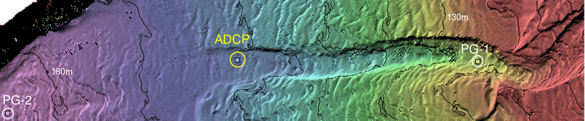
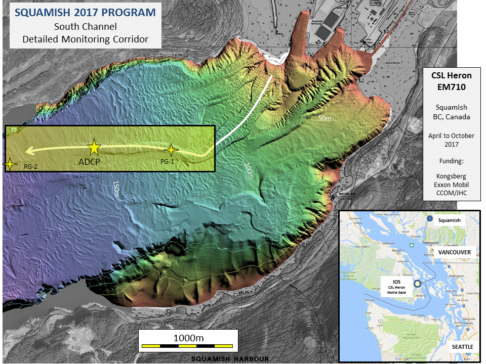
The aim in 2017 was to monitor flow events in that 2 km section of the South Channel, particularly the transition from channelized to unconstrained flow. To that end, a 600 kHz ADCP has been suspended 15 m off the bottom close to the channel termination. The plan is to collect a total of 12 weeks of data.  In the first 6 weeks (the data recovered so far), approximately 15 flows, ranging from 0.3 m/s to 2.5 m/s have been detected.

Complimenting the flow information, updated bathymetric and backscatter surveys in April, May and June (and upcoming July) have been performed to measure the morphological change.  As part of the June update, a 1.5 m/s flow was caught in real time, with surveys immediately before, during and after.

A new focus in 2017, is to look at the backscatter image changes. Normally, when running directly on top of the channels, little could be discerned that was not contaminated by seabed slope signatures. This year, offset lines looking obliquely into the channel allow far better delineation of changes in the surficial backscatter signature.

The ExxonMobil funded component addresses the idea of having  sensors in the flow that would be capable of reporting in real time. This year, the viability of leaving pressure sensors on seabed moorings along the channel is being investigated. Should they prove viable (if they survive the high velocity flows), the intent is to use them to trigger acoustic links to turn on high sampling rate data downstream. Acoustic links have not been tested this year due to delays in funding schedule.

location
location of suspended ADCP and two moored pressure gauges (PG 1 and 2) along South Channel floor

The 2017 program is focused along the South Channel. The ADCP is deliberately sited just at the distal limit of channel development in about 165m of water. The two pressure gauges are upstream in 130m of water (PG-1) and downstream in 185m of water (PG-2).

For all multibeam data collected along the south channel corridor, a standard rotated map is presented (yellow rectangle in figure above) that aligns with the channel axis.  All figures included in this report conform to that single common basemap.  This is so that sequential surveys along the channel can be presented in a common framework to illustrate changes over monthly and/or daily time periods.

For more details on how this year's experiments fit within the context of the full evolution of the entire Squamish fan-delta system, refer to this page.


heron outside
Instrumentation:
heron inside

All operations are taking place from the CSL Heron. She is a 10m survey launch owned by the Canadian Hydrographic Service (CHS), on long term loan to the University of New Brunswick.  She is based out of the Institute of Ocean Sciences (IOS) at Sidney, BC.

She is outfitted with a EM710 1x2 degree multibeam sonar system. The frequency range chosen (70-100 kHz) is optimized for the deeper depth seen in the BC fjords. She has been the main component of mapping operations in Squamish since 2011. Combined with a POS/MV motion sensor and C-Nav GcGPS, the mapping system is capable of resolving seabed features with a minimum horizontal wavelength of about 5% of the depth and ~0.25% of the depth.

The Heron is the only means of deploying and recovering bottom mounted instrumentation (suspended ADCP's or grabs). As a result, there are significant limitations on the maximum weight and size of equipment that can be utilized.


Chronology:


page maintained by JEHC