|
GGE 5083 - Hydrographic Field
Operations
2002 St. Andrew Harbour, NB
Instructor : John E. Hughes
Clarke
Winter Term (January - April 2002) and first 3 weeks of May
Tuesdays 1830-2130 and Fridays 1200-1300
|
This class provides an opportunity to plan and execute a coastal marine
acoustic survey. It is designed to introduce both undergraduate and graduate
students to the
practical issues involved in a coastal survey. These surveys are chosen based
on ongoing cooperative research programs and thus survey location, instrumentation
and aims vary from year to year. Whilst in the past this project was primarily
of a nautical charting focus, increasingly the surveys are conducted for
oceanographic, environmental, geologic or coastal engineering purposes.
LEARNING OBJECTIVES
(1) To further inflame that
burning desire to map the oceans
….achieving this through ….
the planning, execution and processing of a coastal marine acoustic survey.
at the conclusion of this course the students should:
- be confident in their ability to design a coastal survey given specific
objectives.
- know the logistical steps involved in implementing a survey
- have first hand experience of the ped in implementing a survey
- have first hand experience of the practicalities of coastal data collection
- understand the steps necessary to take a data set to a final product
CREDITS AND PREREQUISITES
As this is a 5000 level course, it is offered both to graduate and
undergraduate students. 3 credits are earned towards undergraduate degrees,
2 credits for
graduate. In addition graduate students are require to provide a parallel
research paper that examines one of the technical aspects of the field program.
For those
interested in the IHO Cat. A academic certificate, this course provides the
required minimum field operations experience.
Prerequisites for this course include:
- GGE3353 - Imaging and Mapping II
: Submarine Acoustic Imaging Methods
- GGE4042 - Kinematic Positioning
- GGE5013 -Water Levels and Tides
- GGE5072 - Hydrographic Data Management
TIMETABLE 2002
During the Spring Term from January to April, the following meetings will
take place:
- Tuesdays 1830-2130 - Seamanship and Pilotage Course inb E11
- Fridays 1200-1300 - weekly meeting to monitor camp pr0 - weekly meeting to monitor camp preparations.
The field component of the Hydrocamp 2002 will extend from April 28th to
May 18th For the first two weeks we will be based at the Huntsman
Marine Science Centre in St. Andrews during the field acquisition stage (the
CSL Heron will be based at the SABS, Brandy Cove DFO wharf). For the third
week, we will move back to UNBF to complete the data processing and presentation
component.
COURSE SEQUENCE
Duuring the term, two Coastguard-approved training programs (given by the
Fredericton Chapter of the Canadian Power and Sail Squadron) will be covered.
These will be taught on Tuesday evenings for 3 hours by Rik Hall, David Estey
and David Nickerson. The courses covered will include:
- Boating/Seamanship
- Piloting
In addition to these courses, active preparations will be undertaken to ensure
that we are ready for the field component. This will include:
- detailed planning of :
- hardware logistics
- acquisition sequencing and layout
- accomodation, transport and meals
- processing procedures
- levelling to, and installation of tide gauge at St. Andrew harbour
wharf (from CHS and geodetic benchmarks).
- installation andrks).
- installation and establishment of 3D control for DGPS/ RTK-GPS base
station (provisionally on the roof of St. Andrews Community College)
- access and incorporation of Service New Brunswick (SNB) orthophoto
scenes of the area.
- access and integration of SNB coastal vector database (coastlines,
roads, buildings, property boundaries and spot heights)
- access to and integration of CHS field sounding sheets from late 1980's
single beam surveys.
- access to and incorporation of CHS chart 4113 (inset of St. Andrews
harbour).
- training in:
- OMG SwathEd mulitbeam processing software
- Ashtech Z-12 setup, acquisition and data processing
- Trimble 5700 setup, acquisition and data processing
- RDI ADCP data processing (using WinRiver and OMG tools)
We will meet once a week on Friday at 1200 to monitor progress of all of
this.
FIELD OPERATIONS
The field operation segment is the prime component of GGE5083. It serves
three purposes:
- to expose GGE students to field survey operations (the majority of
undergraduates have no marine experience at all)
- to put into practice, all the theory that has been covered in GGE3353,
GGE4042, GGE5013 and GGE5072.
- GE5013 and GGE5072.
- to meet the minimum field experience requirements of the IHO Cat.
A Academic certificate in hydrography.
Putting on a field component is a significant logistical exercise. The original
intent of the IHO curriculum was directed toward government survey organisations
(predominantly military) that already routinely operate large survey vessels
and employ and train survey staff/officers who are either, already watch-keeping
bridge officers or experienced field survey staff. The Academic certificate
was in-part introduced to allow academic organisations, which can offer all
of the theoretical components of the curriculum, but lack the extensive platform
and technical support, to offer this training.
|
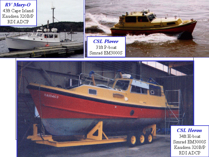
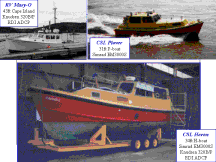
In previous years, the Hydro. Camp had relied upon the University
research vessel, the Mary-O, a 43 foot general purpose coastal platform.
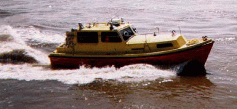
In addition for more specialised gear, we were occasionally able to borrow
the CHS survey launch Plover with its dedicated Simrad EM3000S.
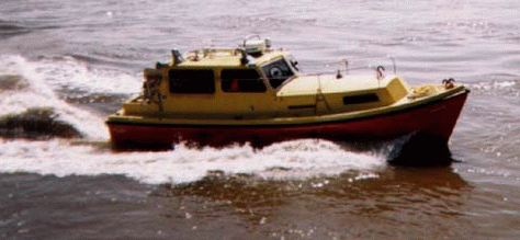
In 2002 we hope to mobilise for the first time CSL Heron. The Heron is a
34 ft dedicated hydrographic survey launch that was originally designed for
use on the CSS Baffin. As part of a 10 year Joint Partnering Arrangement,
the Heron will be loaned to the Ocean Mapping Group at UNB. We are currently
installing our own SimradEM3000S (purchased with the assistance of CFI, Kongsberg
Simrad and ACOA) together with keel mounted 200 kHz Knudsen sidescan staves
and subbottom profiling (28 and 3.5 kHz) transducers and an RDI ADCP.
There has been a
long history
of SE5083.
|
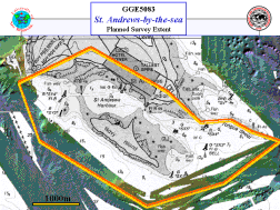
For the 2002 field program, the location chosen is the harbour and approaches
to St. Andrews-by-the-Sea in New Brunswick.
The St. Andrews-by-the-sea haTop">The St. Andrews-by-the-sea harbour and approaches
was chosen for it's:
- proximity to the St. Andrew Biological Station Wharf in Brandy
Cove
- proximity to the Huntsman Marine Science Centre for Accomodation
.
- The existance of archived single and multibeam data in the area..
- An area of high yachting activity with moorings and a dock for
precise survey.
- The data will form an useful addition toward an ongoing research
project looking at the development of the giant pockmark fields in Passamaquoddy
Bay.
|
|
The aim is combine the terrestrial data collected by SNB, with new
bathymetric, backscatter and subsurface data collected from the CSL Heron
multibeam, sidescan and subbottom systems. The aims of the survey are
threefold:
- to build a new, more accurate topographic model of St. Andrews Harbour.
- to map out the distribution of surficial and shallow subsurface sediments
in the harbour and approaches
- to define the tidal circulation patterns within the harbour and approaches.s within the harbour and approaches.
More details on proposed
2002 St. Andrews Project
:
Details on Previous
Year SE4083 Surveys.
COURSE ASSESSMENT
The course assessment will be based :
- attendance
- term-time presentations
- enthusiastic and competent performance during Field Operations
- contribution to the joint survey report.
- a Final Exam
last modified 8th January 2002 by
John E. Hughes Clarke
.