
Dept. Geodesy
and Geomatics
Engineering
University of New
Brunswick
Fredericton,
New Brunswick
CANADA

| |
|
|
Ocean Mapping Group's Role onboard the Nulaijuk.Our role since 2012 has been to test the Nuliajuk's acoustic equipment and collect as much depth, backscatter and sub-bottom data as possible throughout Southeast Baffin Island. The primary purpose being to build up coverage with each transit, improve navigation corridors to the Northern communities, study sea level history, geohazards, and marine habitat mapping. Data collected from the lengthy transits and planned surveys will allow scientists, hydrographers and the general community to better understand the Arctic seabed morphology and improve navigational safety. Each year, collected data is processed and made available on-line to all interested parties.Hydrographic efficiencies of operating a 19 m research platform in the eastern Canadian Arctic. Proceedings of the US Hydrographic Conference, New Orleans, 2013 Brucker, S., Muggah, J., Church, I., Hughes Clarke, J.E., Hamilton, T., Hiroji, A., Renoud, W. Ocean Mapping Group Metadata. Metadata for the Ocean Mapping Group Arctic cruises For more information about OMG's involvement around SE Baffin Island and the data collected contact James Muggah |
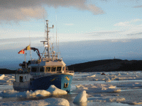 Photo by T.Hamilton |