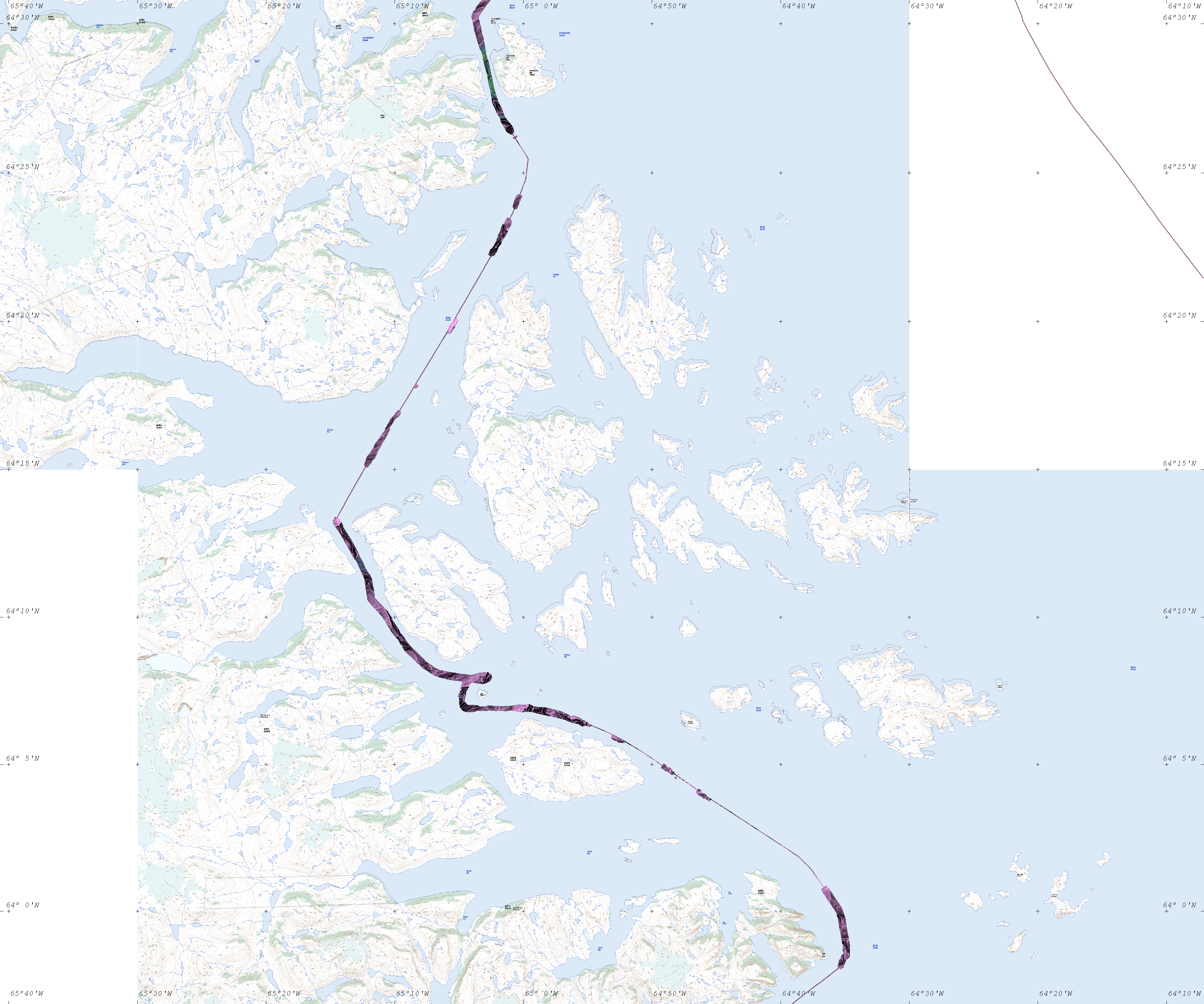
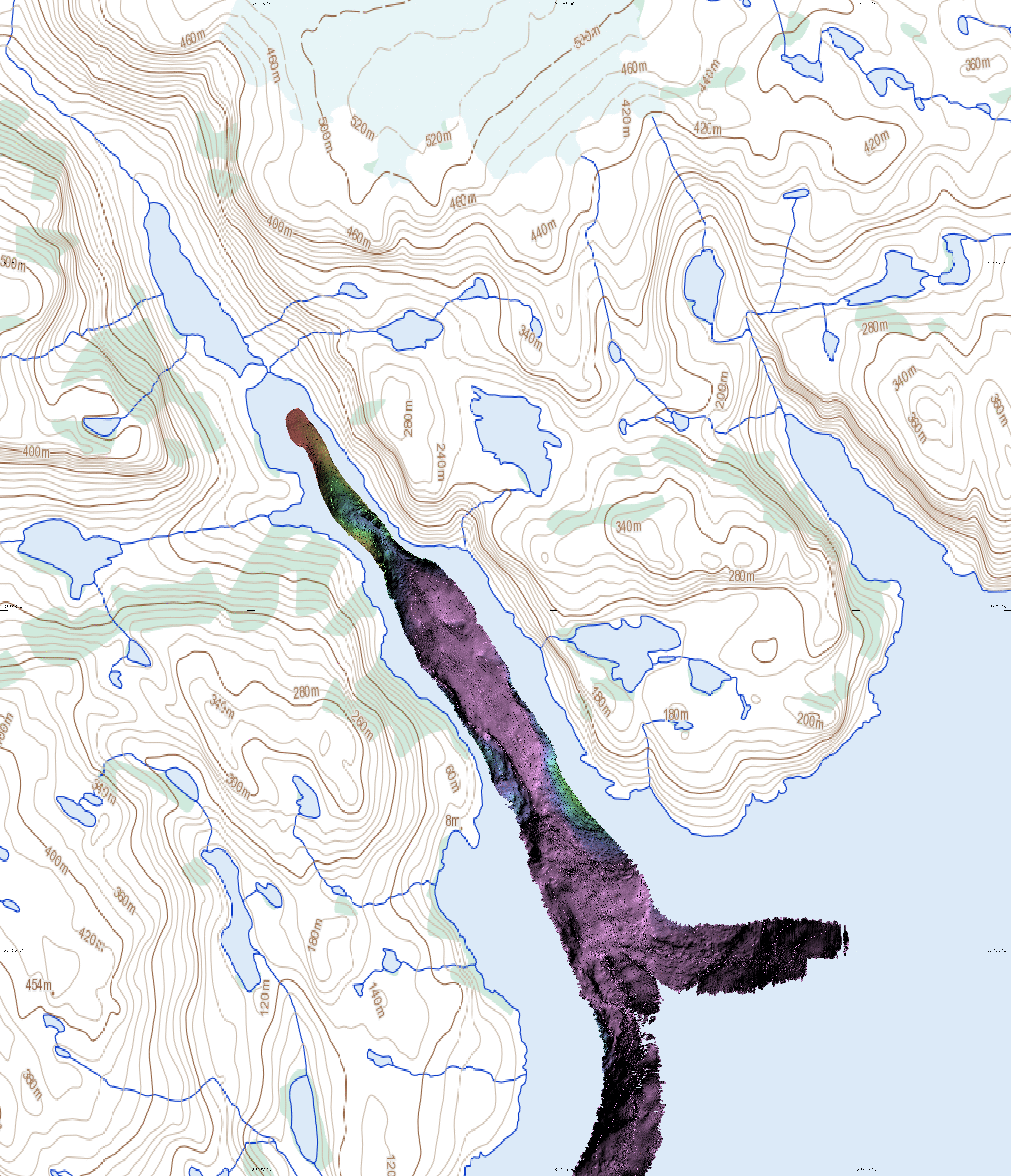
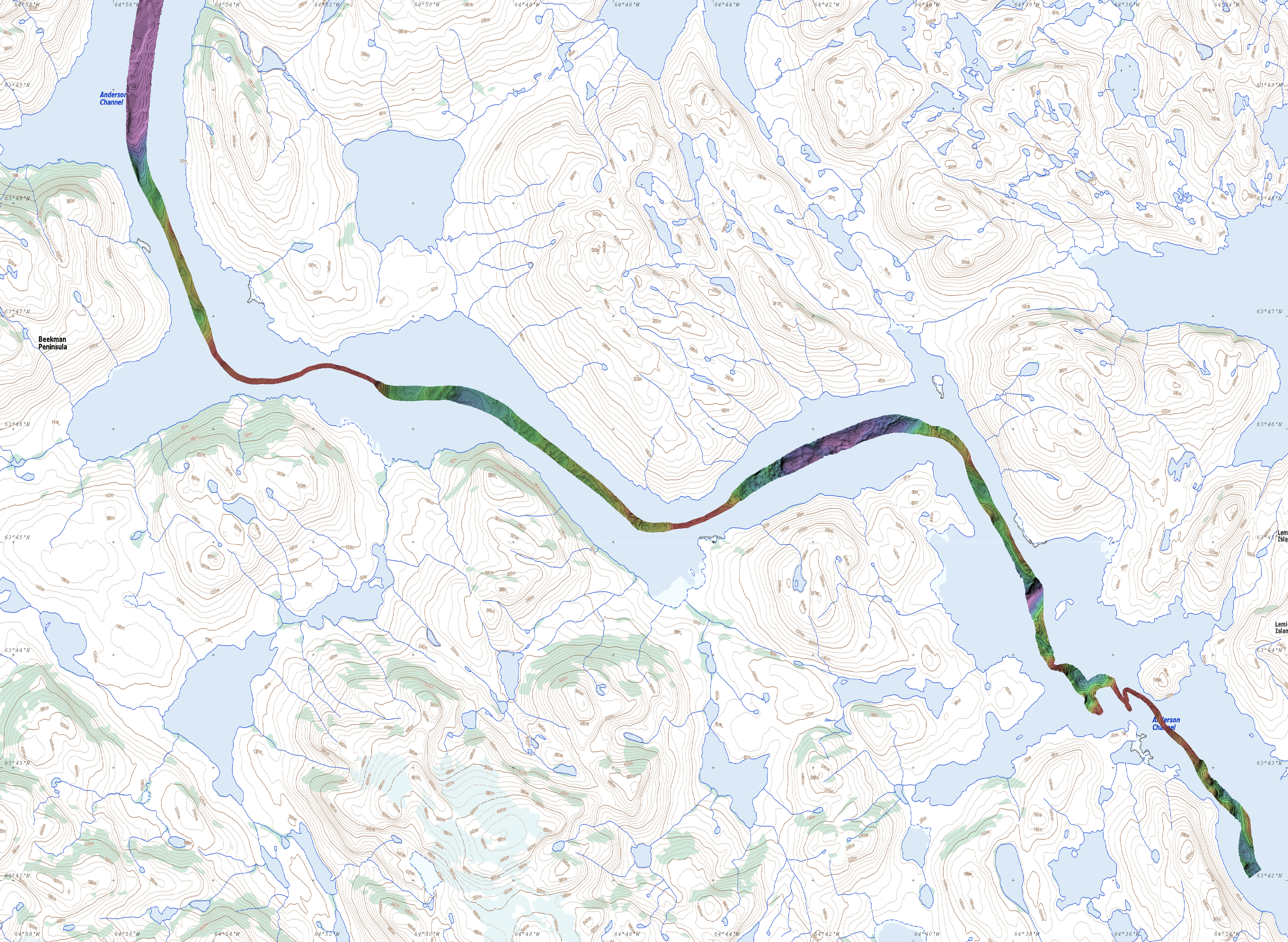
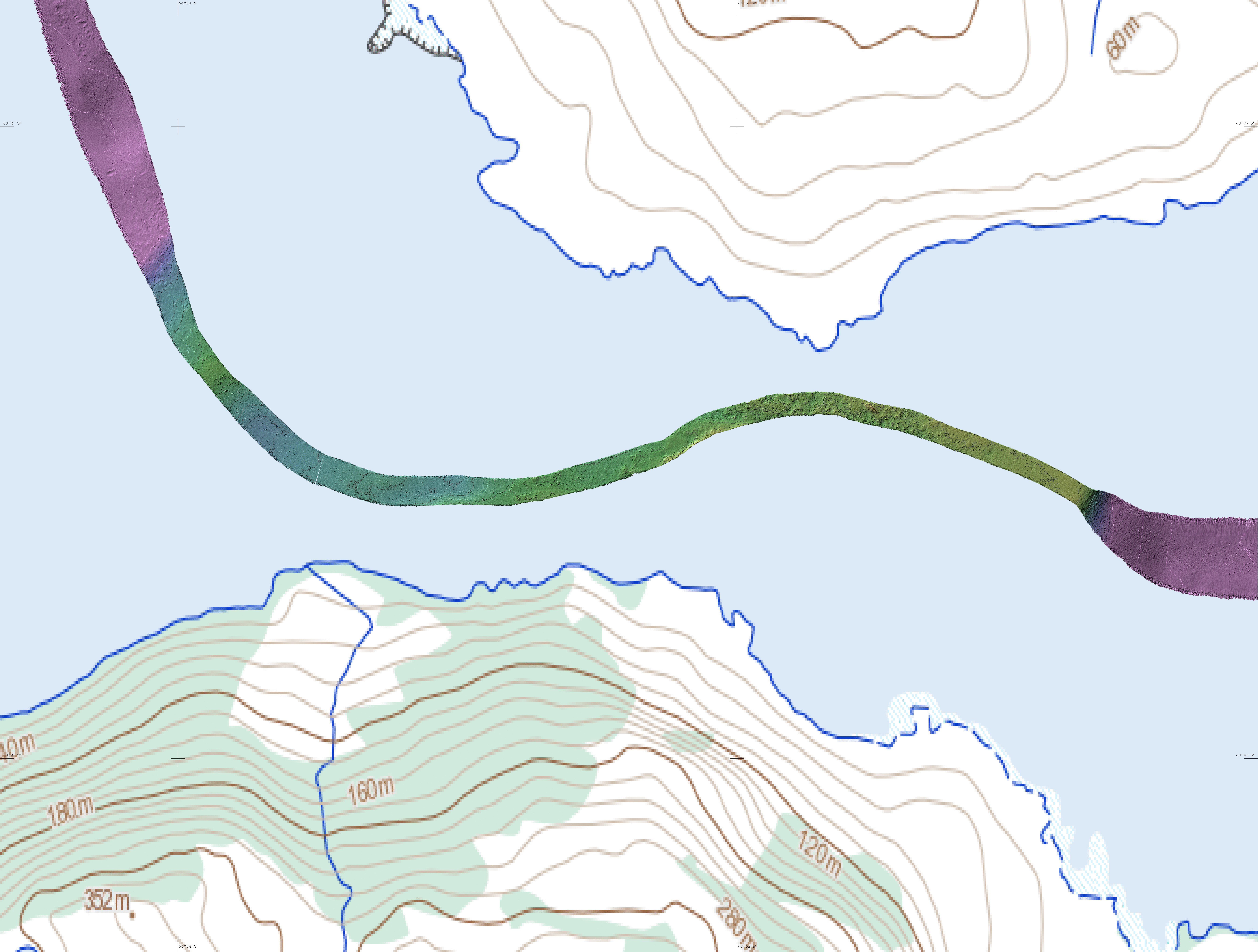
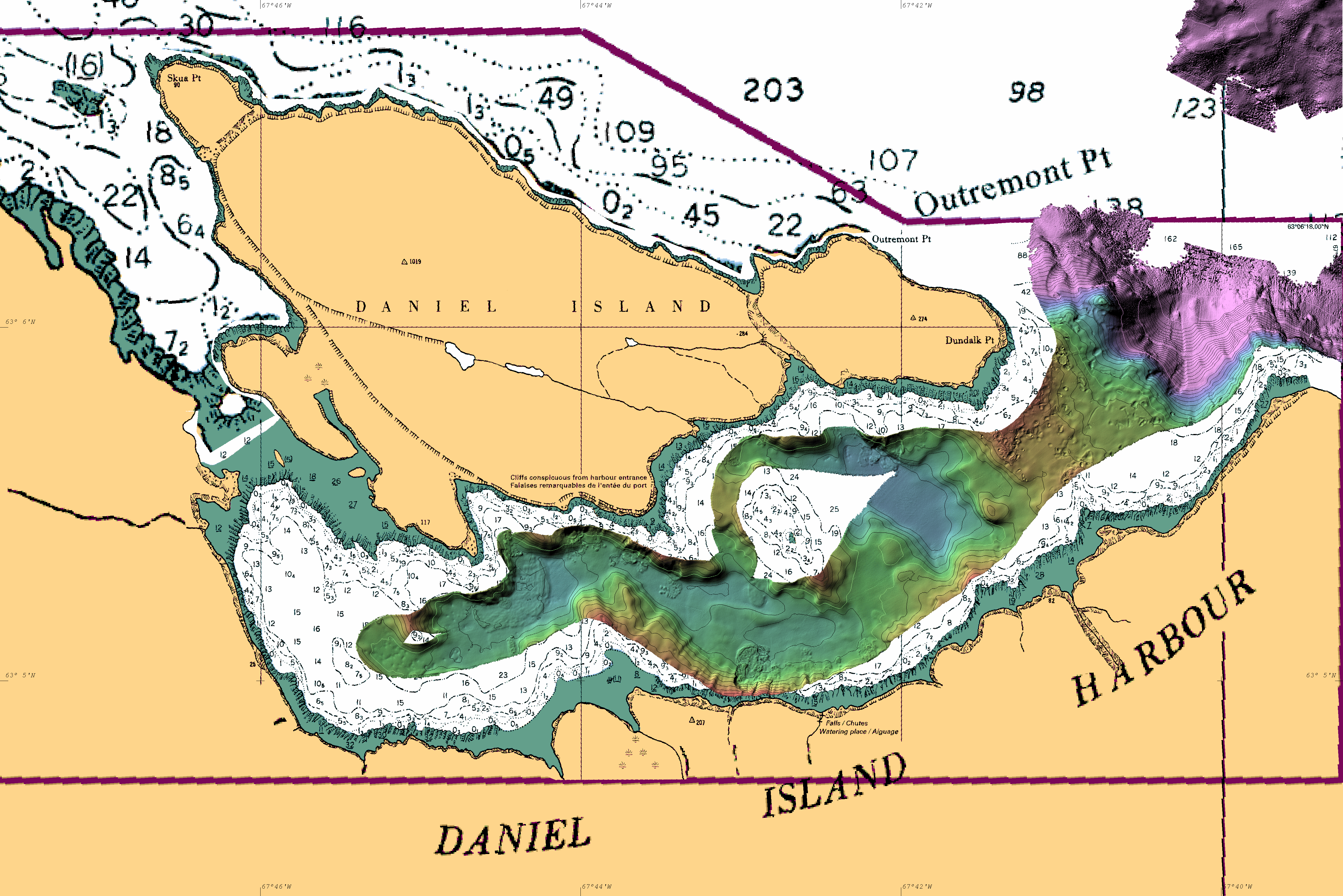
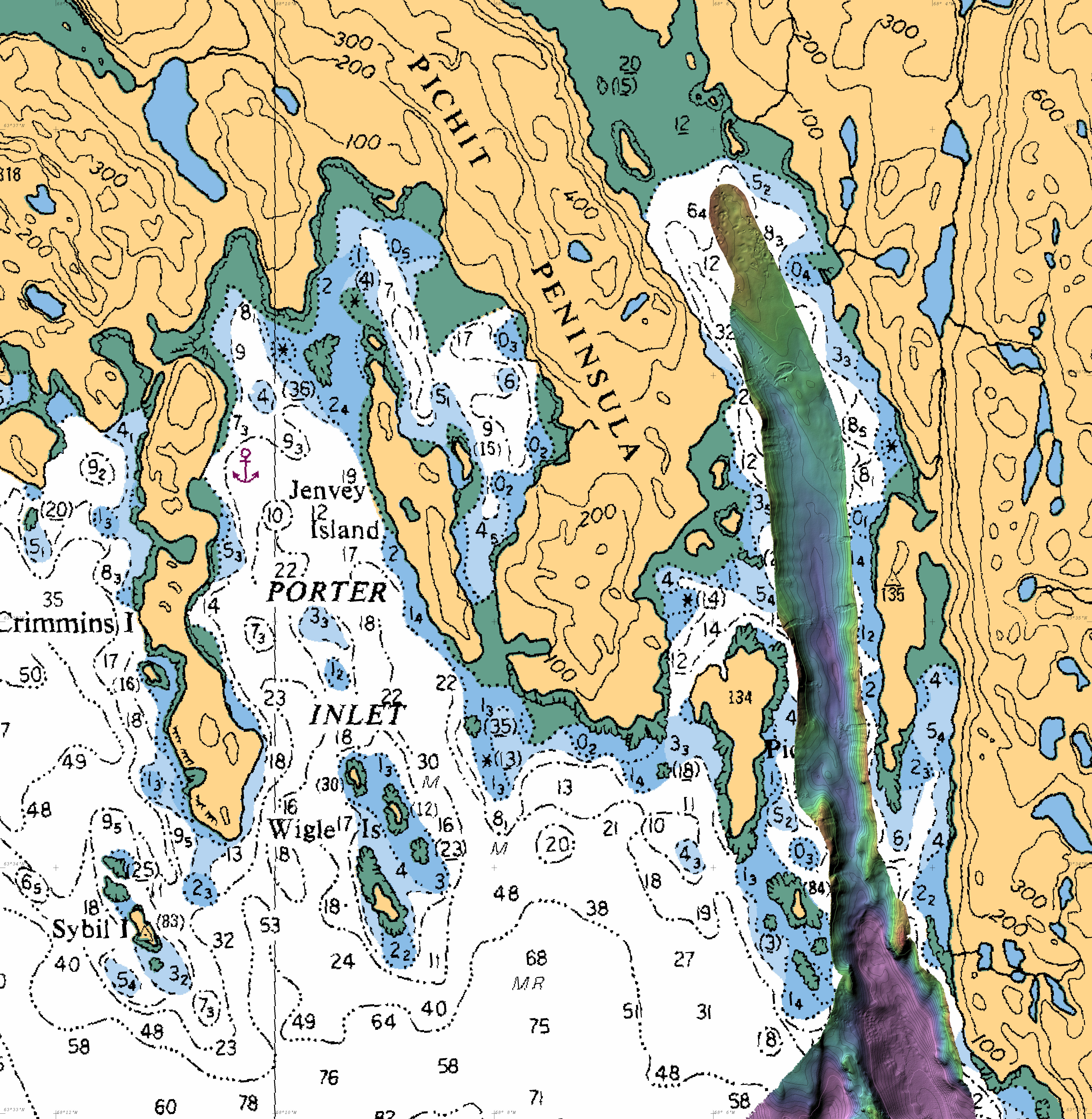
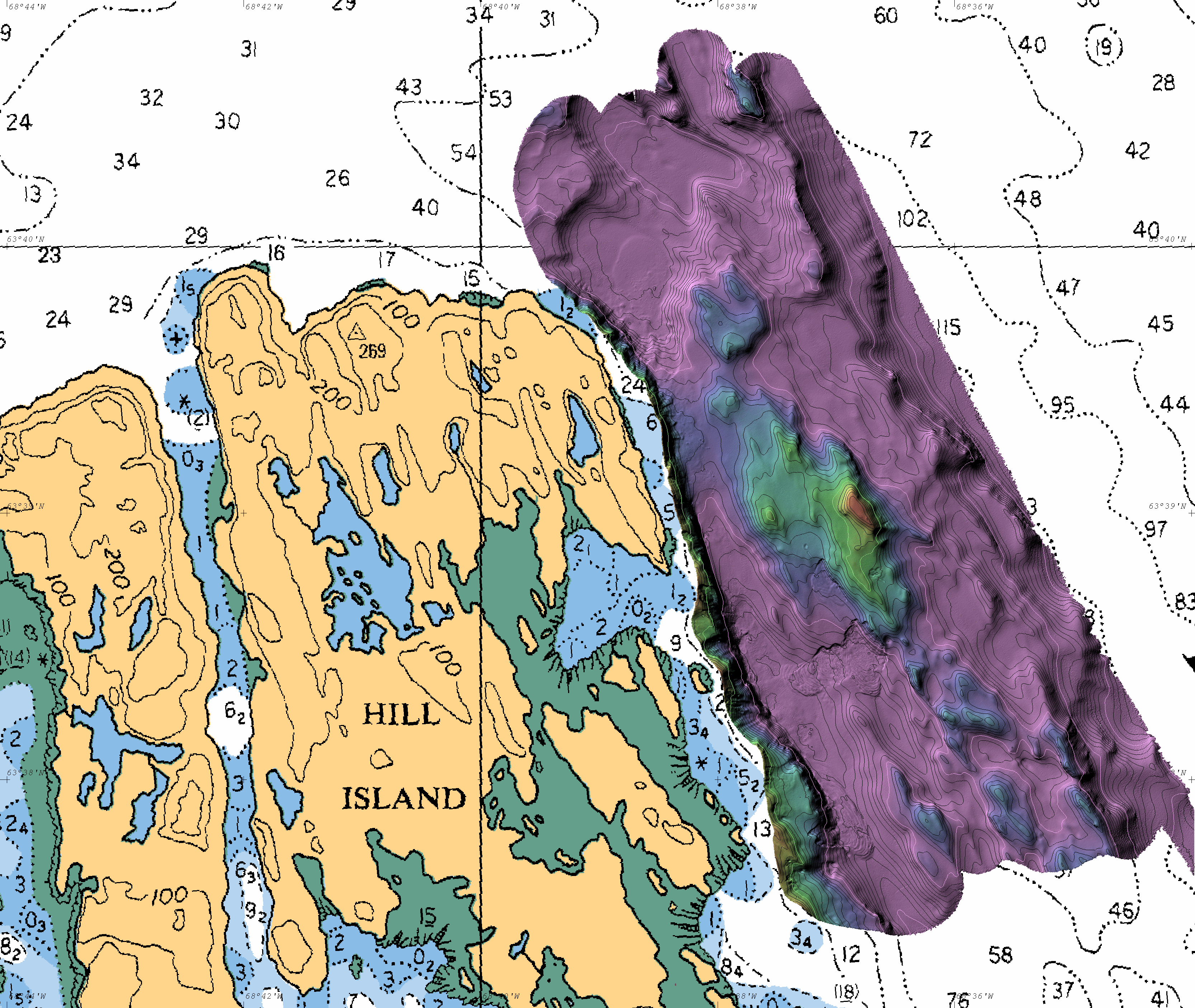
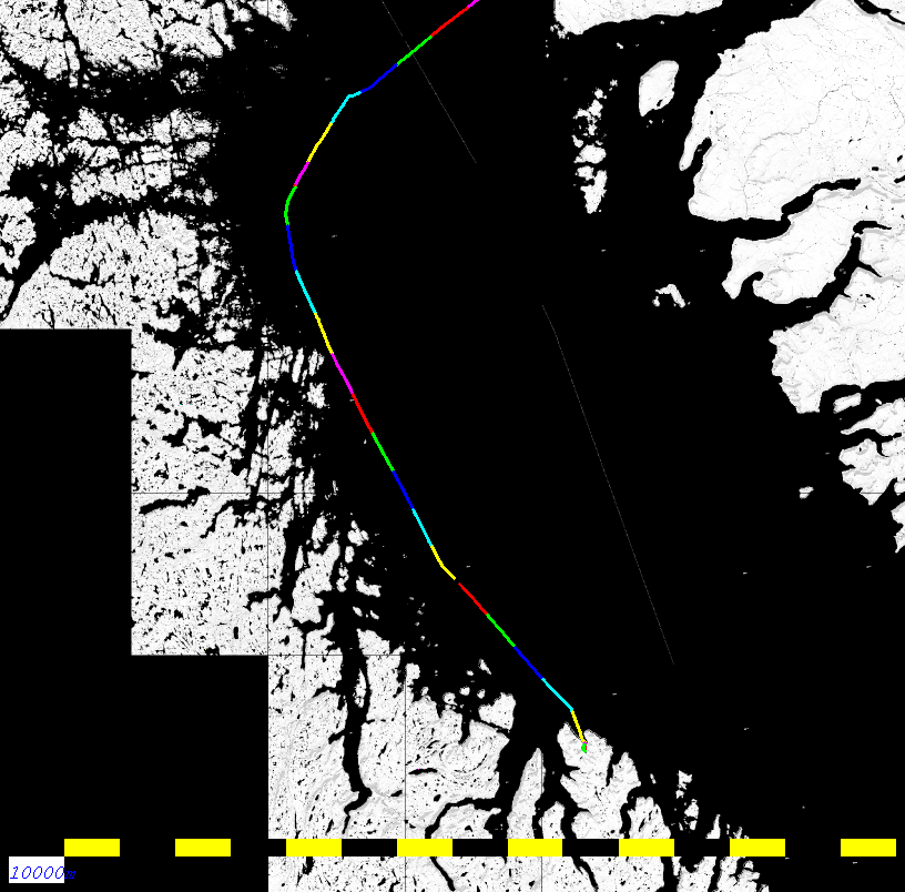
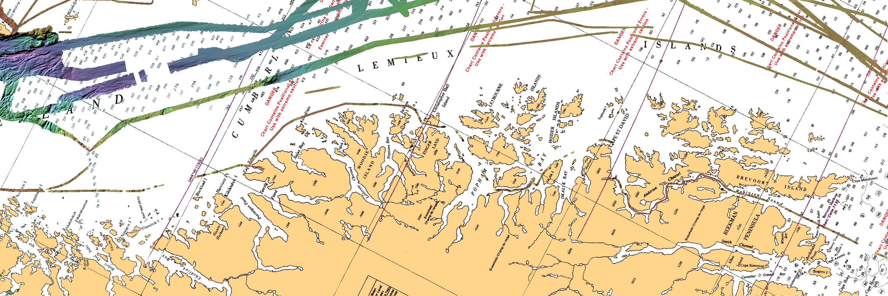
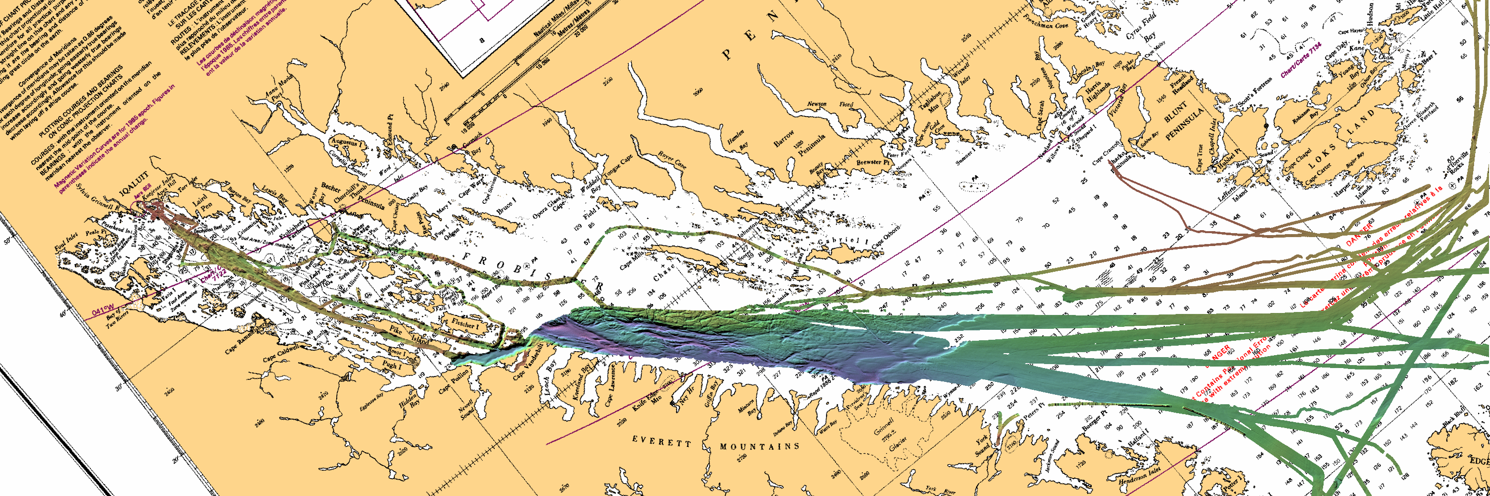
RV Nuliajuk 
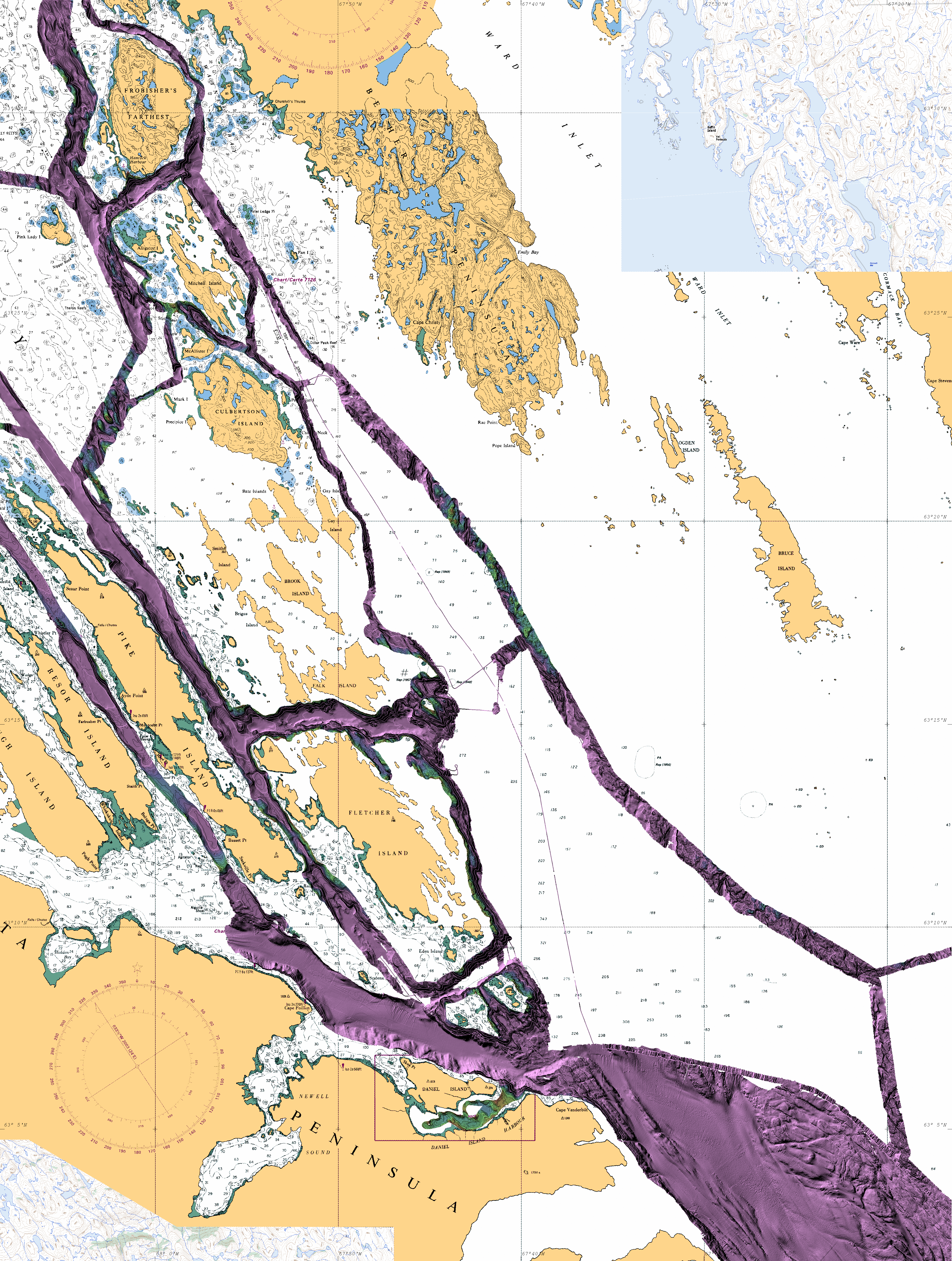
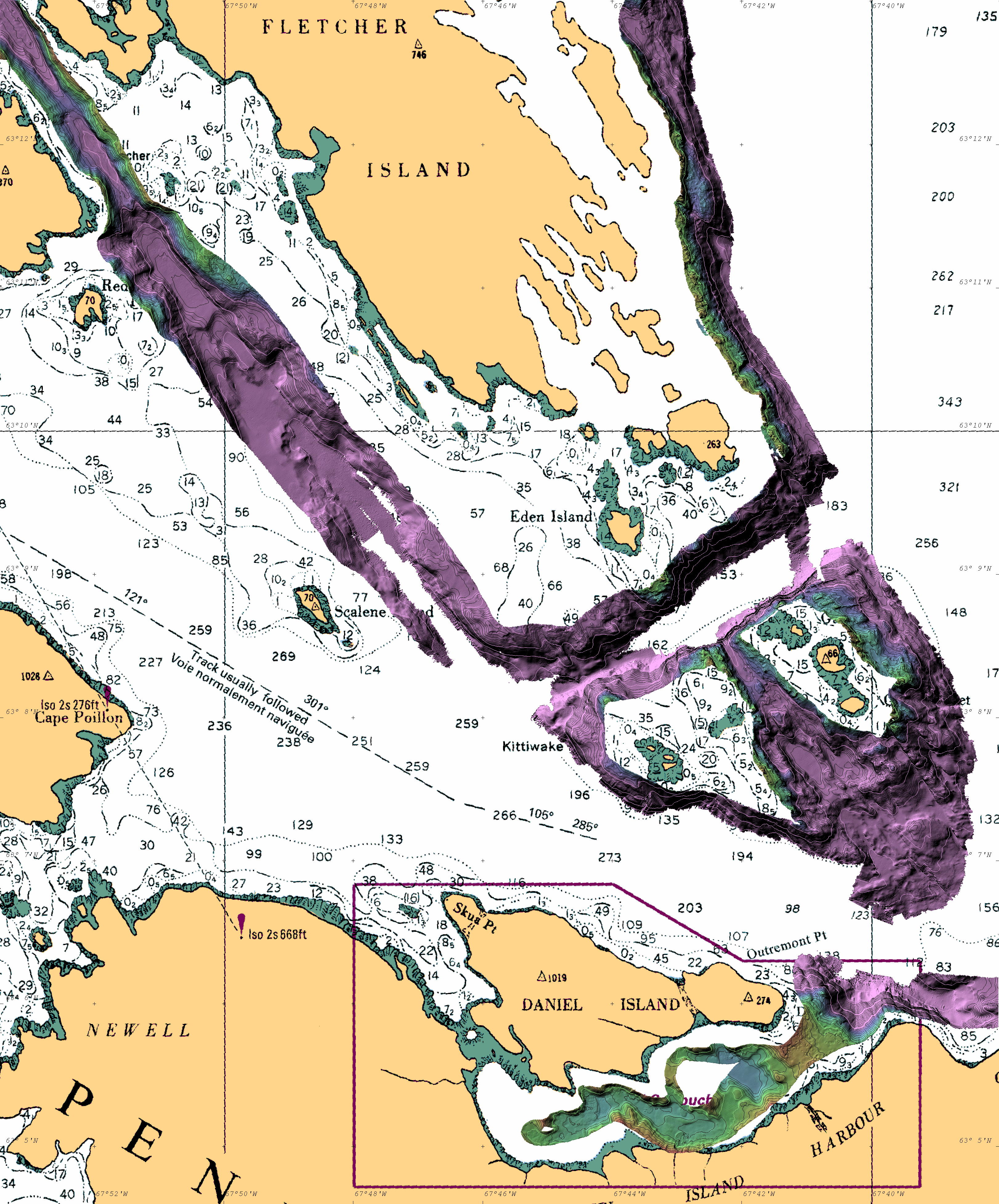
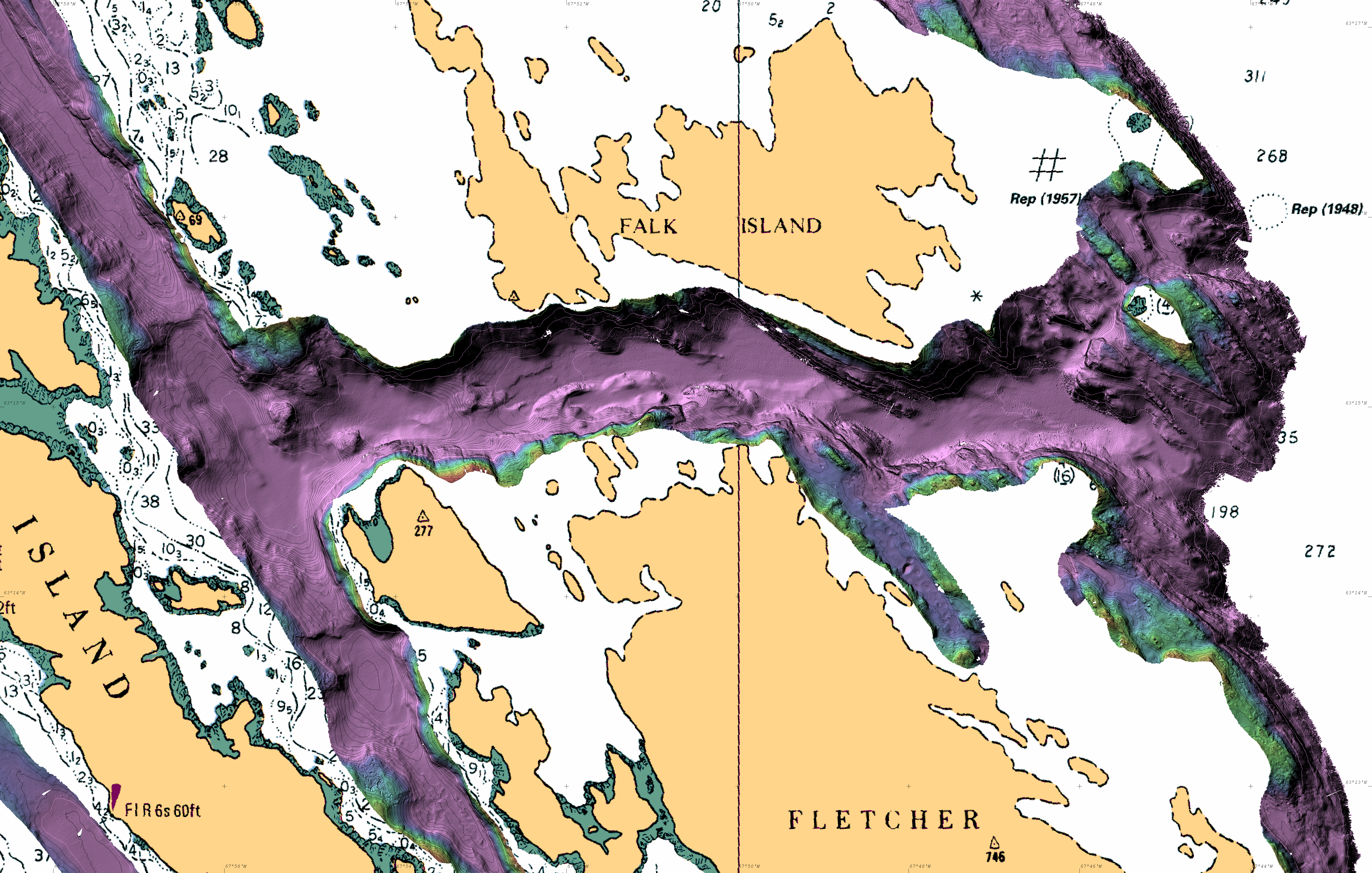
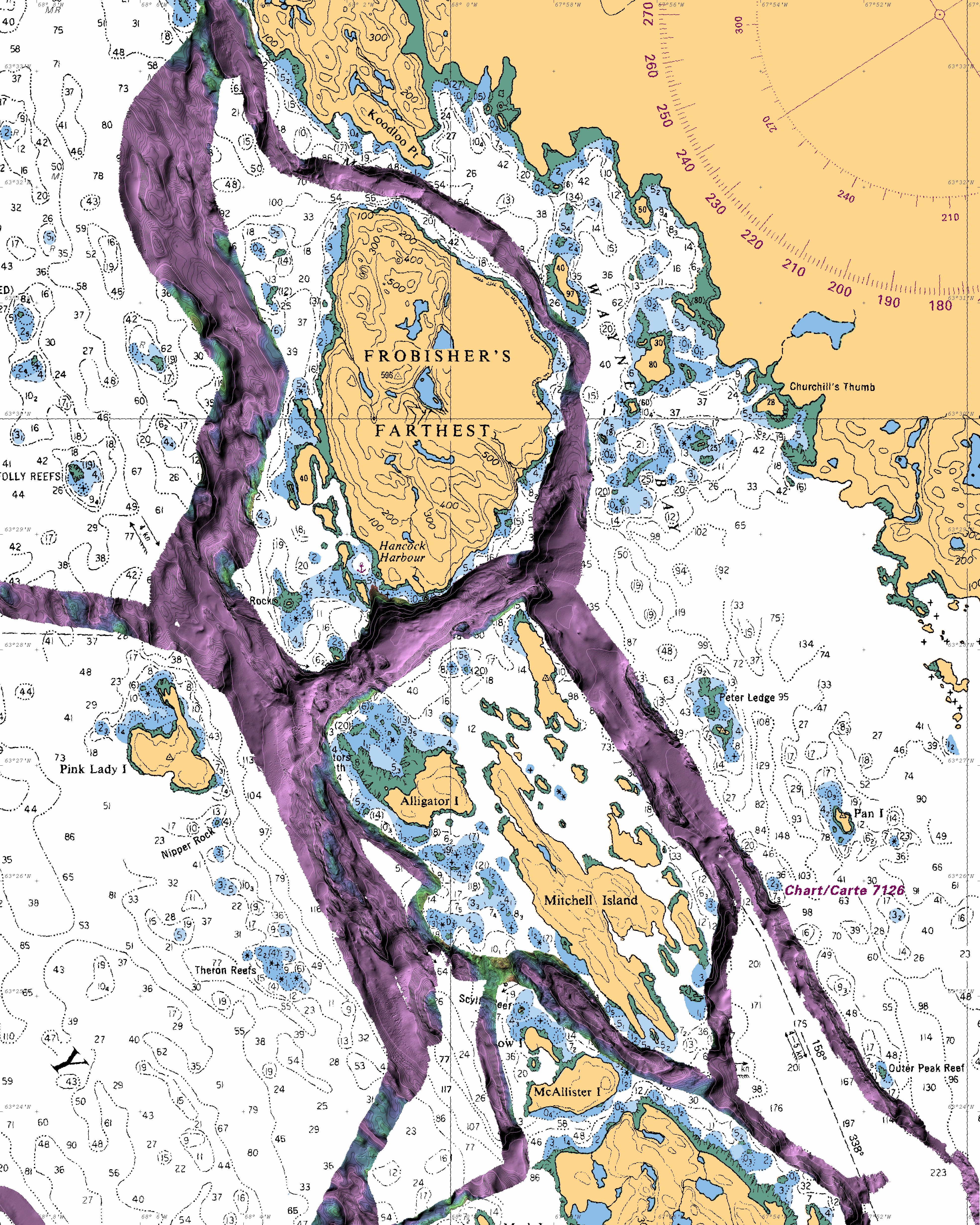
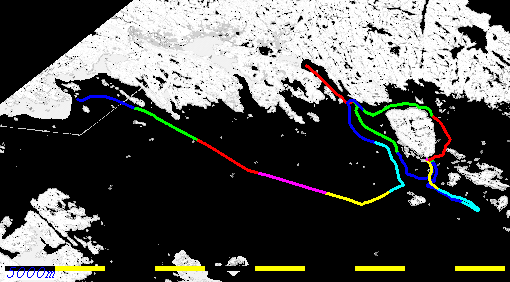
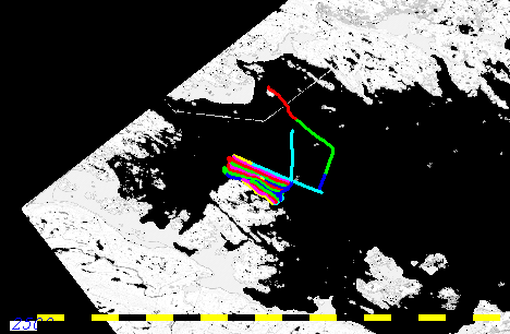
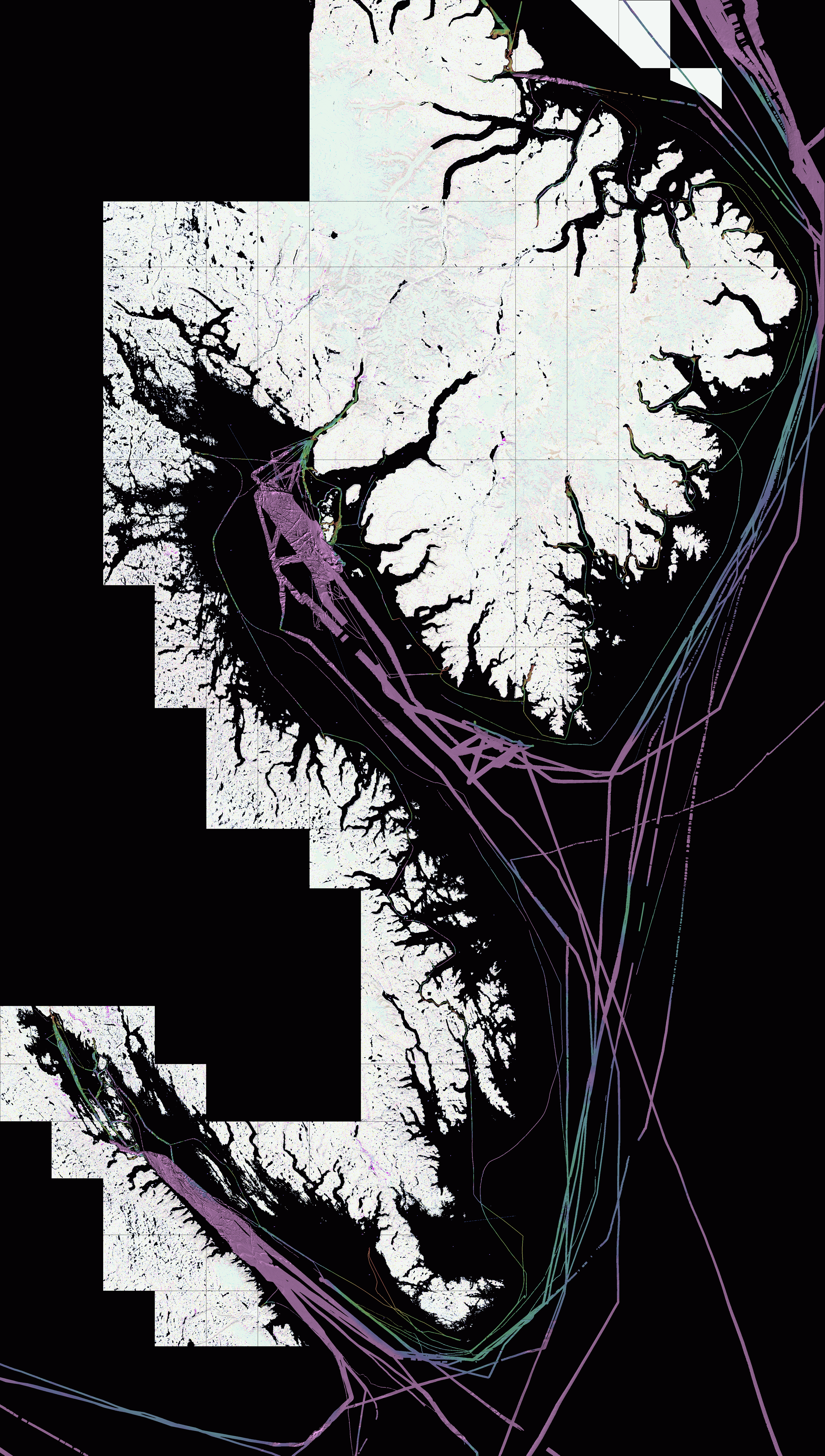
Seabed Mapping Cruise Report
October 18th to 31st 2013
Pangnirtung to Iqaluit
John E. Hughes Clarke and Weston Renoud
Ocean Mapping Group
Dept. Geodesy and Geomatics Engineering
University of New Brunswick
popsicle

Master:  Cecil Bannister
First Mate:  Anton Snarby
Crew:  Jeff Cheater and Levi Ishulutaq

   Version 2.1 - November 14th 2013


overview
Contents:


Cruise Aims:

The RV Nuliajuk is a 19m fisheries research vessel owned by the Fisheries and Sealing Division of the Dept. Environment, Government of Nunavut (GN). The  prime mandate of the vessel is to conduct a ~10 week fisheries research agenda off SE Baffin Island from mid July to end of September. After that time there is a ~ 4 week window in which useful operations can still be done in the SE Baffin area.  That time is currently being utilized for a seabed mapping program. The seabed mapping program is funded jointly by GN, the Canadian Hydrographic Service (CHS) and the ArcticNet NCE. The actual mapping is undertaken by the Ocean Mapping Group at the University of New Brunswick (UNB).

The 4 week window was broken into two legs. The first leg achieved ArcticNet and GN objectives within the fjords around the Cumberland Peninsula from Qikiqtarjuaq to Pangnirtung. That leg is described elsewhere. This report describes the second leg.

The last 12 day leg of Nuliajuk Mapping in 2013 had three objectives:
  1. Pangnirtung to Iqaluit Transit - 3 days
  2. GN Objectives: Inside Passage Small-Craft Shipping Lanes - 2 days
  3. CHS Objectives: Charting and tide gauge recovery - 7 days
As it happened, the flights in and out of Pang on the 18th and 19th were aborted or cancelled losing two days at the beginning. To make up for this (and to avoid bad weather) a through-night transit was made. The end result required that one day be dropped from the Inside Passage investigations and the first day of the CHS work included (useful) transit data along the north side of outer Frobisher Bay.

GN Objectives:
The west side of Cumberland Sound is functionally uncharted. Apart from a single reconnaissance line in 1968 that gets only within 3 nm of the coast, there are no soundings within 10-15 nm of the outer islands. Despite that, Blacklead Island was a well established whaling station and mission in the late 1800's. And Inuit local and traditional knowledge is well aware of the degree of accessibility of that region. Prior to the relocation of communities to Pangnirtung in 1962, many small communities existed on the myriad of bays and inlets on the west side. Even today, hunting camps are frequented routinely on the west side.

West Cumberland Coverage
300 x 100 km rotated map of Western Cumberland Sound
CCGS Amundsen and MV Nuliajuk Multibeam Coverage
(underlying image - combination of CHS charts 7050 and 7051)


Notably, Inuit routinely use an "inside passage" within the islands along the south western flank of Cumberland Sound. This includes Popham Bay, Anderson Channel and Robinson Sound. And to avoid going the whole way around Loks Land, they even use an undocumented route through Lupton Channel and Beare Sound. Most transits are made in local small craft with a draft of less than 1m. Only this year, however, Peter Kilabuk brought his new ~ 2m draft Cape Island vessel through this route. Prior to departure from Pang, Peter shared his knowledge with us and this was the basis for the attempt on this leg to provide a first precisely sounded route through this inside passage.

CHS Objectives:
CHS Central and Arctic are currently improving the charting in the vicinity of Iqaluit. This year, a mission lead by Scott Youngblutt utilized survey launches from the CCGS Radisson to enlarge the available sounding data along the Pike Resor Channel, the main means of navigating through the island chain that closes off the inner part of the bay.

The harbour and approaches to Koojesse Bay (Iqaluit) are well surveyed to modern standards out to a distance of ~6nm (done from 1997-2002).. Outside that, the whole area is covered with 1951-1958 vintage CHS single beam soundings (typical line spacing between ~200m  (< 100m depth) and ~500m (depths > 100m). Given the rock strewn nature of the seabed, this may imperfectly represent all shoals in the area.  Additionally, since ~ 2003, the CCGS Amundsen has added transit EM300/EM302 multibeam corridors from the Pike -Resor Channel. While imperfectly tidally reduced, these corridors do represent a ~ 1500m wide corridor which has 100% coverage.

Frobisher Bay
300 x 100 km rotated map of Frobisher Bay
CCGS Amundsen and MV Nuliajuk Multibeam Coverage
(underlying image - CHS chart 7050)


The aim of the 7 days allocated for this leg are to expand the 100% multibeam coverage from the core Amundsen corridor and build new corridors to alternate inter-island channels including Fletcher, Bartlett and Algerine Passages.


Instrumentation:

Multibeam:
The primary means of collecting bathymetric data is a 300 kHz Kongsberg EM3002 multibeam. In more southerly waters these system are typically used to ~150m depth. In the cold brackish water of the SE Baffin Island, increased performance has been noted due to lower attenuation and high bottom backscatter strengths. Bottom tracking to ~ 250-320m is routinely achievable. Nevertheless, depths exceeding this range are common. 
Primary positioning is provided by the F-185 on COM1 (GGA, HDT, VTG, ZDA) at 1 Hz
Attitude and orientation is provided by the F-185 on COM2 in EM1000 format at 100 Hz
Secondary positioning is provided by the C-Nav 3050 on COM2 in NMEA (GGA, VTG, ZDA) at 1 Hz
Timing is provided by the F-185 via ZDA and 1PPS (Falling Edge)
Single Beam:  a 38 kHz Furuno FCV-30 is the standard fisheries echosounder on the Nuliajuk. It is capable of bottom tracking in excess of 1500m. It is a split beam system, and also capable of forming multiple simultaneous beams (up to 5) for fish school shape determination. For fisheries biomass, the full waveform of a single channel can be exported in the HAC format. No bottom tracking is maintained in the HAC format, however, (or heave or orientation). And when recording to an external disk (the internal disk is too small), it slows down the ping rate and often freezes the sonar for up to a minute at a time.  Thus for this leg, full waveform logging was not used.

In survey mode, bathymetric bottom tracking data is available for a single channel. The NMEA DPT strings are logged by the Aldebaran system on board. interleaved with the ship's Furuno GPS system generating ZDA, GLL and VTG strings. The raw data are in uncorrected metres assuming 1500m/s and no draft. Although the system is stated to have an internal heave correction capability, it is clear that the data is not heave corrected. As the data is time stamped, the F-185 heave could be applied in post processing if desired.

For this leg's survey operations, these data are only used in depths greater than ~ 250m where the EM3002 bottom tracking is lost.

Subbottom Profiler:
A Knudsen K3200 2kW, 2 element 3.5 kHz subbottom profiler was run continuously after the transceiver power supply board was replaced on the 23rd.  A 16ms FM pulse was used (5kHz bandwidth).  From the 28th onward however, intermittent failures of the Knudsen PC terminated the logging. In general the high tidal currents in the area preclude any significant soft sediment build up so little subbottom penetration was noted.
The system received the F-185 positioning and is heave corrected using the same source.

example 3.5 kHz
Example of 3.5 kHz subbottom profiler record
Western Iqaluit Anchorage - JD303 - ~150m depth - 10m contour lines


On the last day, the Knudsen was used off Hill Island with excellent results (see figure above).

Searchlight Sonar:
A Furuno CH-300 searchlight sonar system operating at either 85 kHz ("low") or 215 kHz ("high") is installed on the Nuliajuk. This is an essential component for safely surveying in uncharted waters. It was standardly used in HF mode as it is not synchronizable and this minimized interference with the EM3002. The LF is only required for ranges in excess of 500m anyway. It was routinely used on a 200m range using horizontal scan at a user-selectable depression angle (typically 5° to 10° examining 17 to 35m depths) . A forward looking +/- 48°  sector was used to monitor upcoming shoals in that depth range.
The system uses a mechanically tilted and rotated pencil beam  with a beamwidth of 4.5° at HF (10.5° at LF).  The beam is rotated in 6° steps, taking around 5 seconds to complete one 96° scan at 200m range.
This system provides the means to robustly detect upcoming shoals at a distance of 150m+ so that there is adequate time to turn or stop the vessel. Due to the rocky and unpredictable nature of the submerged geomorphology in the SE Baffin Island area, without this system, almost none of the operations in uncharted waters would have been attempted.

Positioning and Correctors: 
CNav 3050 and 2000 GNSS Receivers are the prime source of precise positioning available onboard.  Real-time RTG output from the 3050 is available and the 3050 also generates RTCM differential corrections for the inertially-smoothed GPS solution from the F-185. Both the 3050 and the 2000 raw pseudo-range observations are logged for PPP or PPK post processing.
CNAV 2000: The output is recorded using a serial logger. The logged data is converted to Rinex format using a proprietary CNAV converter that must be run on 32-bit Windows. Files are split by the serial logger 24 hours from logging start.

CNAV 3050: Is the secondary positioning for EM3002 and provides RTCM correctors to F-185. Logged by C-Setup to a proprietary format. Can be converted to Rinex with C-Nav converter.
COM1: configured to output GGA, VTG, ZDA at 1 Hz, supplied to EM3002 as secondary positioning.
COM2: configured to output RTCM 9 correctors to the F-185
Positioning and Orientation: 
A CODA Octopus F-185 GPS-aided inertial navigation system provided 100 Hz orientation and 1Hz position.The position is an inertially-smoothed differential solution reduced to the vessel RP. Roll and Pitch accuracy are reported at the ~0.025° range (1 sigma). The heading accuracy is supposed to be at the  0.05° level.  Real time heave is reported to be at the 5cm or 5% of range scale. However, as with other real-time heave solutions, long period drifting of the real time solutions over time scales of a minute or more at a level of 5-15cm is common after manoeuvres. The F-185 also provides a delayed heave solution ("iHeave") which is continuously logged asynchronously with the GF-185 mcom files. Should it be desired, those heave solutions could be substituted.


Sound Speed: 
 Typically one SVP per day was collected. An AML SVPlus (SN3310), on loan from the CHS was used which records pressure, sound speed and temperature. From this the salinity was back-calculated. Given that the daytime air temperatures are now below zero, almost all river runoff has ceased. Below ~ 5 metres the water mass was almost entirely invariant. Beyond the maximum depth of a dip (ranging from 60 to ~ 360m) the deepest temperature and salinity reading was combined with a 300 to 500m decibar pressure to estimate  the sound speed at that depth. The Simrad S01 format TSV file was transmitted to SIS so that, as well as an asvp profile a valid attenuation coefficient file was generated.

On the gondola, an AML SV and T probe was installed providing 1Hz readings continuously. A 60 second long median filter of those 1HHz values was used to peform beam steering.
As a backup, a Castaway TSZ probe, usable to 100m was available.

svp profiles
svp
                  location
All SV-T-S(derived) profiles obtained in Frobisher Bay
Map showing locations of 4 of the 5 SV profiles collected.

Frobisher Bay SV Profiles (T and Sv, Salinity derived):
Anomalous differences between the surface sound speed and the lowered probe were only noted in Lewis Bay (presumably the result of remnant river run off). As the gondola SV probe was used for beam steering and the surface brackish layer was thin, the consequences are minimal.

Lever Arms, Reference Frames:
The Ship's Reference Frame (SRF) was established by a static survey while the vessel was in dry-dock The survey, performed by Anand Hiroji and James Muggah in May 2013, used the IMU mounting plate as the Reference Point (RP). The RP local level was established as parallel to a surface defined by a series of bollard tops (the vessel wasn't level in dry-dock).  The EM3002 is  mounted pitched up 1.98°  w.r.t the SRF but is assumed to be aligned with the reference frame in heading and roll. Any subsequent angular discrepancies noted in the patch test are assumed to be a result of the F-185 IMU body misalignment with the SRF.

The following offset are entered into the SIS installation fields:
The primary positioning came from the F-185 which outputs an inertially smoothed trajectory of the RP.

Draft Estimates:
These are entered as the elevation of the RP with respect to the nominal waterline (WLZ). For all operations, the waterline is assumed to be the top of the white painted band. Forward, that band submerges and aft it is emergent (i.e.: static nose-down trim of the vessel) as illustrated in the photos below. Throughout the 4 week period, the draft was not observed to significantly change (<~0.10m). The vessel was refueled at Qikiqtarjuaq and again at Pangnirtung.

The following photos were taken at the end of the cruise showing the location of the top of the white waterline (the RP to WLZ reference used). The vessel is slightly heeling to starboard. The waterline top drops towards the bow and meets the actual waterlevel at about the location of the RP ((roughly below the porthole location).
port side
rear
stbd side
port side waterline   
stern waterline
    stbd side water line


On the last day 30th October, (JD303), squat trials were conducted. Weston Renoud will be analyzing the resultant RP PPK trajectories (Iqaluit has a permanent observing base-station)  to to see if any squat trends can be observed from 0 to 8 knots.

Lowrance Single Beam: A Lowrance single beam sounder was used from the larger RIB for the Hancock Harbour survey and revealed the potential of using the RIB as an inshore survey and shoal investigation tool. A custom conversion program was written to take the position, bottom track and echo trace into the OMG Knudsen format for post-processing. As well as confirming the validity of the bottom track, the echo-trace seems promising for seabed vegetation studies (see figure below).

Lowrance Trace
Lowrance Digital Echo Trace - showing seabed vegetation (and surface bubbles from breaking waves).
Three sections across Hancock Harbour, 29th October 2013.

rib
would be better with a cuddy...      
rib
   showing transceiver/display mounting
ribmount
showing antenna and transducer transom setup. 
rib
                      mount
    showing detail of transducer installation
Hancock Coverage


The Lowrance logs a 3200 byte echo trace with an associated depth, position and time. The time, however, is relative to the start of logging, so either a waypoint must be made at that point or the time manually recorded. The only reason for a time fix is for tidal reduction. There is no heave input and the draft offset has to be added after the fact. It is not yet clear what sound speed is used in the range estimation.

The RIB single beam is a useful tool for establishing depths in waters too shallow or constricted for the Nuliajuk to safely operate. On this leg the system was used just once in Hancock Harbour. The figure to the left  shows the achieved sounding coverage (plotted with respect to the 1958 sounding sheet).

One option being considered for the 2014 field season is to install a small swath system on the RIB to improve the usefulness of the data that can be collected.


Tidal Reduction/Vertical Referencing:

As with standard ArcticNet survey procedures, our prime source of vertical referencing is to use the DFO WebTide. This provides a Mean Sea Level (MSL) referenced elevation. Webtide is designed to optimally reproduce tidal constituents at previously observed stations around the Arctic. It will not, therefore, account for any non-tidal water level forcing. It does however, elegantly cope with the rapidly varying amplitude and phase of the tide around the SE Baffin peninsula.

The newer Arctic9 model does resolve Frobisher Bay (left figure below). The previous edition (Arctic8) specifically excluded Frobisher Bay (central figure below). The default approach for OMG processing is to select the nearest node of one of the three available WebTide models that cover the archipelago (Arctic8 or 9, Hudson Bay and NW Atlantic). When a vessel position is within the mesh, it would make more sense to perform inter-node interpolation, but as the mesh extents do not cover all of the inshore (cutting off small inlets), the nearest option ensures that the mesh edges are extrapolated into those inlets. The degree of extrapolation needs to be limited however. Particularly for the case of Frobisher Bay as it would be worse to apply a grossly extrapolated Hudson Bay or NW Atlantic model inside Frobisher Bay, than to apply no tide at all. Thus a series of model-specific masks, defining the allowable limits of extrapolation, are used for all ArcticNet WebTide processing (right figure below). As can be seen, prior to 2012, Frobisher Bay was specifically excluded from application of any tidal model.

Up to the end of the 2011 field season, the Arctic8 model was used for all ArcticNet extrapolations. Therefore all Amundsen data inside Frobisher Bay have not had any tide applied. Only with the 2012 and now 2013 field seasons, has the Arctic9 model been used for multibeam data collected within Frobisher Bay. Therefore, it is recommended that those Amundsen data be identified and reprocessed with the Arctic9 model. All Amundsen data included and presented in this report have had that done. But this needs to be applied to the public online distribution.

arctic9
arctic8
choice map
Arctic9 model coverage
Arctic8 model coverage (blue)
NW Atlantic model (green)
Hudson Bay model (red)
Polygons defining default model
choice for ArcticNet surveys
prior to 2012


The newer Arctic9 model provides a first view of the likely variation in amplitude and phase of the tide along Frobisher Bay. The figures below illustrate the M2 constituent (by far the strongest contributor). As can be see, the amplitude of the tide increases up Frobisher Bay and the phase advances similarly up the bay indicating a rapidly progressing wave.

amplitude
phase
M2 amplitude - white line 0.1m contours, black line 1m contours. 
3.4m amplitude at head, 2.5m at mouth
M2 phase -range : -11 to -60 degrees (1 degree is roughly 2 minutes delay for an M2 tide)

Loks Land Bypass - One of the objectives of this mission that was not achieved was to investigate a potential navigable channel between Loks Land and the Blunt Peninsula. A path through the  Lupton Channel and Beare Passage is reportedly used by local shoal draft craft (most recently, Peter Kilabuk in July 2013). The Sailing Directions, however, mention that at the northern mouth of the Lupton Channel "a line of breakers forms from shore to shore when a rough sea from the Davis Strait meets an outgoing tidal stream" and "Powerful and erratic currents prevail in Lupton Channel making navigation difficult and dangerous". 

If the tidal streams are indeed so strong, it would limit the usability of such a short cut. Examining the figures above indicates a significant offset in both tidal range and phase on either side of the peninsula that could produce extremely strong currents through such a channel. The M2 tidal amplitude goes from 2.0 to 2.5m across the peninsula and the phase of the tide is ~30 degrees (~ 1 hour) different on either side.

The other issue that the Arctic 9 tidal model can help to elucidate, is the typical nature of the tidal streams and their times of reversal as the tidal wave propagates through the line of islands that restrict the entrance to inner Frobisher Bay. The animation below shows the magnitude and direction of the tidal streams, inferred from the M2 constituent of the Arctic 9 model in inner/upper Frobisher Bay. Note that the fidelity of such a model depends on how well the shape of the inter-island channels are resolved. Part of the aim of this mission was to better resolve those inter-island passages. Notable, a new, large cross section channel was in fact found.

M2
          currents Frobisher .
animation of current vectors for the M2 component over one tidal cycle.


Data Quality Issues:

EM3002 - depth limitation:
As mentioned earlier, much of the area surveyed is at, or beyond, the attenuation limit of a 293 kHz system.  After ~ 75m depth, the full +/-65° sector cannot be utilized. In general, a maximum swath of ~ 300m in muds (400m in gravels) is achieved by ~ 150m depth which stays stable until ~ 200m after which it contracts and dies by ~ 250m in muds (~320m in gravels).  The two performance envelope plots below illustrate the actual achieved coverage as a function of depth, either in soft sediment or hard sediments.

low BS
high BS
example performance envelope in low backscatter sediments
example performance envelope in high backscatter sediments


extinctionIdeally, for depths greater than ~ 150m, a lower frequency multibeam should be used. As the areas covered routinely dropped in and out of the maximum achievable depth, lots of data cleaning has been required to edit out the mistracking in the event of an "unfathomable" bottom. The system has to be kept logging even after the bottom tracking has been lost in case the seabed rises up again. For those instances, the Furuno single beam data is substituted.

The figure to the left illustrates surveys that go beyond the extinction depth of the EM3002 off the mouth of the Falk Channel. Reconnaisance lines were run in an attempt to link the Falk Channel survey to the Bartlett Approaches corridor across an area believed to be generally deep but with anomalous soundings (charted depths are in fathoms). The Furuno 38kHz data is substituted and retains the ability to disprove anomalous reported obstructions present in the old chart.


mapEM3002 - near nadir tracking noise:
 Throughout the month, it is clear that on certain seafloor types (generally smoother), the bottom tracking around nadir exhibits a characteristic series of deeper spikes. While the RMS effect of these spikes on the whole dataset does not exceed IHO Order 1 criteria, the individual events are outside (deeper) than that criteria. These spikes show up clearly in sun-illuminated images (see figure to left).  While many of these are caught by the spike filter, one could not engage the filter too strongly, as in areas of boulders, it would remove many of the boulders. Fortunately most of the spikes are to deeper depths and thus not biasing the bathymetry shallow.

The outliers are expressed in both phase and amplitude detections, but most notably in amplitude detections. When the associated water column imagery is compared to the actual bottom tracking (see figures to left below), it is clear that the intermittent deep spikes do not correspond to an apparent alternate echo at that range. Indeed, for most of the mistracks, there is a clear bottom echo within that beam trace above the chosen tracking point that matches the tracking on the neighbouring beams (see figures to right below that show the intensity time series for the mistracking beam). Thus it is not actually clear why it is choosing a deeper range?

The 2012 Nuliajuk EM3002 data needs to be reassessed to see if this phenomena was present then. It notably degrades the fine detail definition for the near nadir data.

Four examples of watercolumn imagery of swaths in which pronounced deeper bottom mistracking is present.
across
trace
across trace
across trace
across trace
water column imagery - grids spacing at 10m intervals
zoom of watercolumn showing
intensity trace for the specific mistracking beam


mapEM3002 - outer beam low S/N: swathed
Even in shallow water, on almost any seafloor, it was apparent that the last few beams beyond ~ 62° tended to abruptly have a higher bathymetric noise level (see figure to right).  This showed up in sun-illuminated grids as a distorted edge to the swath (see figure to left). Where overlap was achieved the weighted gridding filter removed this. Nevertheless, it has not been seen on other EM3002 installations.

The water column imagery clearly show a significant drop in the seabed scattering strength for the last few degrees on each side. It is presumably this low S/N that is resulting in poor bottom tracking. Even though the grazing angle is very low, in extreme cases the bottom detection is forced to revert to amplitude detection.

It does correspond to a poor quality factor (as defined in the old depth telegrams, not the new Ifremer one). The phase QF is stored in the lower 6 bits (maximum value of 64) and corresponds to the residual to the regression through the phase values. For most operations, the outer 5 beams on either side showed QF > 64. Initially an attempt was made to edit based on a QF over this threshold. But at times the data is fine and thus this would result in artificially trimming the edge of good data.

The animation below shows 10 successive water column images illustrating the abrupt drop in the apparent seabed echo at the edge of the swath, corresponding to the increase in bathymetric noise. Note that the noise is worse to starboard  which in this case is slightly downhill. Both sides exhibit this noise characteristic at times.

It is not clear whether the low S/N in the outer edge of the swath is a failing of the transducer beam patterns, or a result of the installation in the gondola, or a transceiver electronic issue?

anim WC
animation of 10 succesive pings
still
still of one ping
still
still of another ping
 
BIST tests  results:
Surprisingly, the BIST tests this mission indicated passing all the requirements. Previously the receiver noise test failed.  The actual test files are still on board, but will be added to this report in a few weeks.

In summary, the EM3002 hardware on board (now ~7 years old) appears to have some small, but not insignificant issues. At this time it is not clear whether the transdcuer or transceiver could be improved by a factory maintenance cycle. There are no confirmed plans to drydock the vessel yet, but that may change in the spring.


Survey Areas:

A brief description is included here of all the main survey areas/objectives. An overview figure is provided along with details on data quality and comparisons to existing data (if it even exists).

For all figures presented, a common colour range and contouring schema is utilized. The upper end of the colour range (solid red) is depths less than 20m and the lower end of the colour range (purple I think), represents 100m. This highlights the areas of concern to navigational charting. The contours in white are at 50m intervals to a maximum depth of 400m (beyond the range of EM3002 tracking). The contours in black are at 5m intervals to a maximum depth of 200m. The resolution of the images depends on the area covered. All images have a geographic grid embedded for registration.

Where no modern charting is present (or just small scale 7050 or 7051 chart coverage), the backdrop is the NRCan toporama topographic map series. These are the most reliable for coastline location. They also include a surprising amount of detail on offshore reefs, as inferred from aerial photography. The only problem seen in these maps is the outline of the Nunavut Land Claims boundaries which are clearly slightly offset.

For the Inner Frobisher Bay area, charts 7121 and 7122 are preferentially used as backdrop. Around the inter-bay islands, the coastline agreement between the CHS charts and the NRCan toporama is adequate (within 50m). Further out in the Bay (around Ward inlet), the two coastline representations are off by several hundred metres. At this time, it is not clear which is more representative although the NRCan are generally assumed to be better positioned.


West Cumberland Sound Corridors

mapsOpen Water Shoal Constriction:shoal
From Imigen Island to Blacklead Island, an inshore transit corridor is gradually being developed along the west side of Cumberland Sound. By combining  the July 2013 Nuliajuk transit and this leg, a ~ 300m corridor is now available through an area previously completely devoid of any depth measurements. For the majority of the transit corridor, the depths are  over 100m and often beyond the capability of the EM3002 (>250m). For those deeper water sections, the single beam depth from the 38kHz Furuno is substituted (see figure to left).

 Along that corridor, however, here is one notable constriction at ~ 65° 31' N, 66° 49' W. At this point (box in figure to left and see figure to right), on the inbound transit, a least depth of 24m (re. MSL) was found on the eastern side. On the outbound transit on this leg, a shoaller depth of ~ 15m (re. MSL) was observed on the western edge. As a result, at the moment, there is only a ~ 150m wide corridor that appears safe for navigation. These shoals clearly represent a NNE extension of the islands to the SSW.

It is strongly recommended that the spatial extend of these shoals be better determined to establish a wider safe transit corridor.

Cape St. EdwardsCape Edwards Anchorage:
A nearby bay just SE of Blacklead Island was investigated for an overnight anchorage. A sill with a least depth of ~ 20m was apparent and an inner basin which is at least 70m deep is present. At the head of the inner basin, a suitable anchorage area in < 30m is available.

Data was only collected during the inward bound transit as in the morning, the F-185 required ~ 1 hour for recalibration while leaving.


LittleCote and NeptuneLittlecote Channel to Neptune Bay:
An additional protected-water corridor can be found by diverting into the Littlecote Channel and then out again through Neptune Bay. While a longer route, it is completely protected from open water swells. Peter Kilabuk reports that the constriction at the SW extremity has ~ 2 fathoms of water. This may be too tight for the Nuliajuk, although, once investigated, there may be a deeper channel.

There was no time in this leg to investigate that alternate route.


Popham BayPopham Bay
:
When approaching the northern entrance to Popham Bay it is possible to take a few cuts inside some of the islands. The main one is Christopher Hall Island but there are two small islands off Jackson Island too. Popham Bay consists of two main deep segments connected by a cross channel . The cross channel is shallower, and has significant currents. At the time of transit (~1800UTC, 22nd October) the flow in the most constricted section of the cross channel  (64° 11.7'N, 65° 12.3'W) was ~ 3 knots to the north. That time corresponded to slightly before low water at Imigen Island.

The depths of the deep segments are preserved by integrating the Furuno 38 kHz single beam data.

There are alternate possible passages through the islands within Popham Bay. The original proposed route had to be modified to avoid breaking shoals at ~ 64° 07.8'N, 65° 01.7'W which lie between two small islands that exist on the NRCan Toporama sheets.


Cape St. David anchorageCape St. David Anchorage:
Just inside the northern entrance to the Anderson Channel a very tight, but suitable anchorage was established in a narrow and steep sided inlet on the north side of the channel.

It is necessary to go right up to the head of this inlet to find suitable depths (<30m) for anchoring. At that point the width of the bay is only ~ 200m wide.


anderson restrictionsAnderson Channel:
This section represents the shoallest depths encountered on the inside passage. There are in fact three constrictions. The first two are primary depth limited, but the third, by the unnamed island provides a significant lateral constriction as well. This was the location indicated by Peter Kilabuk. 

At the southern end of Anderson Channel is a connecting channel to the east that potentially might provide a clear passage to open water. This should at some point be investigated.


north anderson
centre anderson
south anderson
northern Anderson Channel constriction
central Anderson Channel constriction
southen Anderson Channel constriction

Robinson Sound:
Once clear of the constrictions, the passage opens up into Robinson Sound extending down to the end of the shelter provided by Cape Murchison. No further constrictions were encountered.

Near Monumental Island:
Originally, it was intended that a reported navigable passage inside Loks Land be investigated. But due to deteriorating weather, the Nuliajuk undertook a diversion seaward that passed close to Monumental Island. That area is covered by CHS Field Sheet 285501 -Brevoort Island to Loks Land (1:72,000 1958). The depths encountered were compared to the reported depths on that field sheet. No significant anomalies were encountered.

Outer Frobisher Bay Corridors

frob
          mapBetween Maclean and Gabriel Islands:frob
        chart
A single line of soundings is depicted on chart 7050 (see figure to right) indicating a deep water passage between the line of islands on the north side of outer Frobisher Bay.  If this corridor can be re-established and expanded, it provides a more protected route for small boat passage through Outer Frobisher Bay. At the moment, the preferred route for vessels is along the southern shore which is deep and has now been extensively surveyed by the Amundsen over 10 years of multibeam transits (figure to left).

 This corridor was followed (as well as possible given the uncertainty in the registration of that small scale chart). Almost the whole passage was greater than 100m. The shoaller areas were clearly when the track approached one or other side of the channel with deeper water always apparent on the outer side. At the northern end when turning to the west, a particularly deep point (?> 300m) was encountered suggesting a deep trough that probably could be followed to provide a new corridor to the NW up into Ward Inlet and ultimately up into Anna Maria Port.

It is the intention that all future transits of the Nuliajuk in and out of Frobisher Bay will follow and expand this corridor to provide a well surveyed alternate route on the northern side.


nrcan backdropApproaches to Bartlett Narrows and Deep Passage:
All the existing  soundings on 7050 (shown in more detail on 7121 and 7122) and all the ArcticNet Amundsen transit data is on the southwest side of Frobisher Bay leading towards the currently preferred inter-island channel (Pike Resor). If a vessel is to approach Bartlett Narrows or Algerine and Deep Passages, it requires steaming through sparsely charted waters.

Therefore a new corridor was established linking the main approach to those northern channels. The reconnaissance soundings reported indicate that it is mainly deep immediately to the east of the line of islands although isolated apparent shoals exist. 

As the EM3002 only reliably tracks in shallower than 250m depths, the corridor location was chosen along the NE side of the route in depths generally about 150-250m of water.


Inner Frobisher Bay Surveying

In order to get into Inner (Upper) Frobisher Bay and approach Iqaluit, it is necessary to negotiate a route through an "intricate labyrinth of islands of all sizes extending from shore to shore" (Sailing Directions, Arctic Canada, CHS ). These line of islands have five known navigable passages based on an intense single beam campaign by the CHS in the 1950's.  As originally requested the focus of the mapping was to be on improving the multibeam coverage around, and through, the known inter-island passages.

Fletcher ApproachesFletcher Channel Approaches:
The CHS have now almost completely resurveyed the recommended corridor through the Pike Resor Channel. The Fletcher Channel, however, is an almost equivalent conduit. The existing soundings data from the 1950's and indicate a similar sill constriction at the SE end of the channel. In order to better define this corridor there was a requirement to start undertaking 100% coverage of this channel in the hope of opening it up for more traffic.

The centre of the  whole length of the Fletcher Channel deeper than ~ 60m has now been covered. And the approaches, between the Bird Islands and Daniel Island have been further investigated.  The deeper water to the south of the Bird Islands is all already covered by Amundsen transit multibeam data.


Falk
          ChannelFalk Channel:
The most remarkable finding of the mission was the discovery that a deep channel exists between Falk and Fletcher Islands. Apparently the area had previously never been investigated. The 1950's surveys extend ~0.5 nm into the western end, indicating deep water but abruptly terminate. At the eastern end there are three rocks awash that are reported without any intervening soundings. The  main 5 nm long channel otherwise appears completely unsurveyed.

The current Sailing Directions refer to the inter island passages east of the Fletcher Channel and report "Air photographs show drying ledges extending from most of the islands and most of the channels between them appear to be encumbered with rocks and reefs".

Currently the Pike Resor Channel is the route recommended in the Sailing Directions. The second option would probably be the Fletcher Channel. The SE end of the Fletcher Channel, however, shares the same lateral and depth constrictions which results in accelerated tidal flow making navigation problematic. The more NW section of the Fletcher Channel is both wider and deeper with correspondingly reduced tidal streams.

The Falk Channel branches off from the wider, deeper section of the Fletcher Channel. And the full length of the new Falk Channel is both wider and deeper (usually over 200m depth) than either the Pike Resor or Fletcher Channels. Although current meter measurements have not yet been performed over a spring tidal cycle, it is strongly suspected that the tidal streams in the Falk Channel will not be particularly challenging (at least compared to the mouths of either Pike-Resor of Fletcher Channels) as it is deeper and wider.  And the channel width is at least > 750m at all locations which should allow two vessels to pass safely. To negotiate the turn at the western end into the Fletcher Channel, over 1 nm is available in depths > 50m.

The weaker tidal currents may result in a later opening of this channel. One of the reasons the Pike Resor has been previously favoured is that the extremely strong tidal streams promote early ice removal.
 

Northern Channels:

Northern ChannelsAlgerine and Deep Passage
s:
In July, a first transit was obtained through Algerine and Deep Passages which was then widened as part of this mission in October. The surveys agreed well with the 1950's data. As noted in the Sailing Directions, however, the two ~90° turns required are problematic for navigation. During the first July transit, on the Spring tide flood, significant whirlpools were recognized that would submerge large blocks of floating ice.

The approach to Hancock Harbour was covered while deploying and recovering the RIB in an attempt to retrieve the CHS tide gauge (unsuccessful unfortunately). The Nuliajuk did not attempt to enter the inner harbour. A likely safe transit was noted using the forward looking searchlight sonar, but there was no need to take any risk. The RIB undertook a brief single beam reconnaissance of the inner harbour and those data are presented earlier in this report.

Bartlett Narrows:
This was surveyed at HW (Neap). The main concern is the sill between Scylla and Charybdis Reefs. A sill depth of 16 fathoms (re. CD) is reported in Chart 7122 and 6-7 knot peak tidal streams are present there. A minimum depth of 28m (re. MSL) was found at the same location. During the Neap water period, at the time of survey, no more than ~ 2 knots maximum was observed.

The branch to the SW between McAllister Island and Culbertson Island was not investigated. Even at neap tides, there was a pronounced tidal front and overfalls visible at the NE end of this channel.

Mandarin Passage:
On JD302, to avoid the strong winds, the passage around the east side of Frobisher's Farthest was briefly investigated. The constriction is not quite as tight as the current chart suggests ( a product of generalizing the contours into deeper water to best represents the constraining shoals).  The passage requires no significant course changes and is generally protected from winds. Whether it is open later or earlier than other passages is not known however.

Anchorages:


Daniel Island HarbourDaniel Island Harbour:

While working on the approaches to the Fletcher Channel and the new corridor through Falk Channel, overnight anchorage on three occasions was obtained in Daniel Island Harbour. As a result, reasonable new multibeam coverage of the central part of the anchorage was obtained. The area has been extensively surveyed in the 1950's and is a specific chart insert (712102).

The newer multibeam coverage confirms the older surveys without significant anomalies. The main new information noted is the widespread presence of submerged landslides. Notably, while some of the landslides are adjacent to steeper slopes, they  do not clearly correlate with any subaerial geomorphology.


Lewis
          BayLewis Bay:
While working around the northern channels, overnight anchorage was easiest in Lewis Bay. This bay, and Porter Inlet to the west, have both been previously surveyed as part of the 1950's single beam campaigns.  Originally it was intended that Porter Inlet be utilized as well. The new multibeam coverage confirm the older data without any significant discrepancies.

The only new features of note are the widespread presence of landslides coming off the coastal areas. These look very similar to the phenomena seen in Daniel Island Harbour.


wst Iq anchorWestern Iqaluit Anchorage:

On the last day, as we were already in Iqaluit, rather than lose 3 hours of transit to get out and back to the island chain area, we decided to pick an area outside the modern CHS Kojeese Inlet surveys and map that. The result was an area adjacent to Hill Island (see figure to left). Just to the NW, a shoal region, missed in the reconnasisance 1950's surveys had been recently surveyed using the Amundsen barge EM3002 system (in 2010).  In the deeper Hill Island area covered, the 1950's depths were confirmed without any significant anomalies.


Daily Log:

October 18th: - flights both in and out of Pang were aborted so outgoing and incoming crews not exchanged.

October 19th: - Original intended sailing date. Outgoing flight did leave so crew departed (James, Bob, Kevin) but incoming was cancelled so  Jeff and Weston were unable to arrive.

October 20th: - Incoming flight finally arrives at ~ 3pm.

trackOctober 21st (JD294): - Departed Pangnirtung at 0600. F185 heading clearly wrong. Rebooted and calibrated while steaming out of Pang Fjord. Reacquired calibration and logged data on north flank of coverage. Over Pang Sill with ~ 15m water (schools of fish on sill top providing  false targets for searchlight sonar).

Transited over deep sound, tracking bottom intermittently. Joined up with July inboard transit on west side of Cumberland Sound. Twinned that track. Shoal region slightly expanded (see note elsewhere) but clearly a constriction. Diverged from inbound transit to keep in shallower water towards Blacklead Island. Passed Blacklead at dusk ~ 2 miles off.
Entered uncharted potential anchorage just east of Cape Edwards. Sill least depth of ~ 20m, but deeper inside. Excellent anchorage.


trackOctober 22nd (JD295): - Departed Cape Edwards anchorage at 0600 but F185 heading clearly wrong - waited 45 minutes while rebooted and tried to reacquire a calibration. Finally achieved this outside harbour. Uneventful transit until turned inshore to attempt Popham Bay transit.
Strong tidal currents observed at one constriction (see note elsewhere).

Rounded Cape St. David at dusk. Searched out an unsurveyed narrow side inlet on the north side of Anderson channel for an anchorage. Eider duck impact as entering (flew into, and apparently blinded by, searchlight).  Too deep for anchoring in outer part but ~ 20m in inner most basin. Only ~ 200m wide though. Excellent anchorage.


trackOctober 23rd (JD296): - Departed Cape St. David anchorage at 0600. F185 working well. 3.5 kHz turned on after consultation with Knudsen technical support.
Three constrictions found in Anderson Channel. First two are shoal but not narrow. The third is the one pointed out by Peter Kilabuk. It is both shallow and extremely narrow requiring one to hug the west side of the central island.
track

Overnight Transit: - As we steamed down Robinson Sound past Brevoort, the seas increased. Rising wind and swell from NE were noted as we moved into open water. Decided it was imprudent to attempt an entrance to the Lupton Channel as would be with following wind and seas. Decided to steam outside Loks Land even though requiring an overnight transit.

Headed out to SE towards Monumental Island to avoid seas on the beam,. Then turned due south just west of Monumental Island. Passed south of d'Iberville Rocks at ~ midnight.


trackOctober 24th (JD297): - at dawn, transited through the line of soundings between Maclean and Gabriel Islands. 1-1.5 knot flood tide current with us. Then developed the first line of a corridor just to the south of reported rock and shoal areas toward Bartlett Narrows and Algerine Passage.

Off Bartlett, turned south and ran along the 150-200m contour to define the eastern edge of the island chain. There are no systematic surveys to the east of the island chain. To the west are shoals, and to the east is the deep water (beyond EM3002 tracking depths).

Anchored overnight in Daniel Island Harbour.

trackOctober 25th (JD298): - Departed Daniel Island Harbour anchorage at 0700.  ran east across preexisting deep Amundsen coverage to a point where EM3002 tracking depths are viable. Built a corridor north to join  the incoming transit on the 24th. Ran that up to the mouth of the Bartlett Narrows. Once at the mouth as it was close to HW, so we ran two lines through Bartlett Narrows, in and back out again.

 The return corridor to the south east was twinned all the way back. With three overlapping swaths, there is now a 500m+ wide corridor for vessels wishing to steam to Bartlett Narrows or Algerine Deep Passages.
Anchored at 1800 back in Daniel Harbour..

trackOctober 26th (JD299): - Departed Daniel Island Harbour anchorage at 0700.   Ran a constraining survey around the "Bird" Islands (Gander, Nesters, Gosling, Kittiwake). Then proceeeded to define the deep water approaches to the constriction at the mouth of the Fletcher Channel.

At HW we proceeded through the mouth of Fletcher Channel, adding a few lines better defining the multibeam coverage on either side of the constriction and then ran a corridor up the east side of the channel. At the north end we turned to the NE and  cut the first line of a transit corridor to Lewis Bay.

 Arrived and anchored in Lewis Bay at 1700.


trackOctober 27th (JD300): - left Lewis Bay at 0700. Added two lines on either side of the Algerine and Deep Passage transit corridor. And added two lines on either side of the Bartlett Narrows Corridor. Then proceeded to expand the Fletcher Channel as HW approached.  On returning NW along Fletcher we decided to turn into the opening to the east that lead to the gap between Fletcher and Falk Islands. Prior soundings only extended ~ 1/2 a mile in but indicated over 200m of water.

On investigation it is apparent that there is a wide (>3/4 of a mile) channel with typically 200+m of water all the  way to the open outer Frobisher Bay. The channel passes north of the reported rock awash and shoals at the mouth of the inter-island pass.  Several lines were performed before heading south biulding inshore along the reconnaissance line just to the east of the island chain.
An attempt was made to find a suitable anchorage in an uncharted bay at the south west end of the Falk Channel but the mouth proved to be  foul.
Anchored in Daniel Island Harbour at 1730.

trackOctober 28th (JD301): - Departed Daniel Island Harbour anchorage at 0700.  ran up the eastern flank of the island chain, landward of our previous tracks.  Defining the 40m contour most of the way. Started better defining the mouth of the Falk Channel. Also established that the two rocks awash are not part of the same reef. It is possible to steam between the two and around to the west of the southern shoal. The reported obstruction does not appear to exist. Investigated shoaler soundings in the deep water between the channel mouth and our transit corridor to the NE.

Continued to define the full channel to the 40m contour wherever possible to safely do so. Finished at about 3pm. Headed up the west side of the Fletcher Channel and then built on the transit corridor over to Bartlett Narrows and Deep Passage.

Anchored in Lewis Bay at 1830.

trackOctober 29th (JD302): - up anchor at 0700. Prepared RIB for tide gauge deployment. ~25 knot winds from the NW, with significant seas. Dropped off at ~ 0845 in lee of island closing off Hancock Harbour. Weston and Levi attempted to communicate with the submerged tide gauge. No luck. Deck unit clearly transmitting and codes used were based on the deployment log. RIB proceeded to undertake single beam reconnaissance mapping of Hancock inlet to better define entry depths. Nuliajuk surveying to the south, but sea states marginal for quality data collection. Picked up RIB at about 1030. Decided to take the shelter of Frobisher's Farthest and run the Mandarin Passage. Then proceeded to survey just south of Lewis Bay in partial lee of coastline.

At ~1300 departed for Iqaluit to arrive before dark as freezing spray building up on superstructure.   Winds now gusting to 35+ knots from the NW. Steaming into seas. ~ 1430 (local) noticed that C-Nav has lost its corrections. Perhaps ice buildup on the receiver? Not recovered until at anchor.
Anchored in inner harbour at ~ 1530. Breaking ice off superstructure.


trackOctober 30th (JD303): - Picked up GN representatives at 0700. Proceeded to Hill Island Area. Did a CTD in 250m of water and surveyed until ~ 1500. After that we conducted squat trials while transiting back to Iqaluit harbour.

At anchor at 1600.


October 31st:
- hopefully airborne!


Significant Findings:

For the GN inside passage investigations, the most significant finding was the validation of a viable corridor with > 10m keel clearance through the restrictions in Anderson Channel.

For the CHS work. the most significant finding of this mission was the identification of a previously unsurveyed, safe deep-water passage through the island chain. No prior sounding existed at all between Falk and Fletcher Islands. The seaward mouth had a series of correctly reported rocks awash which presumably discouraged any previous investigations.

The obstruction charted east of Falk Island at 63.266905 N -67.729099 W, reported in 1948 appears to not be present.

Similarly the charted 37 fathom (67m) spot sounding to the NE is actually in an area > 500m.

The 102 fathom (198m) spot sounding to the east  is more like ~ 250m. It may however shoal within half a mile of that area.


Recommendations:


report generated on board by JEHC - October 19th to 30th 2013 - v2.1 finished on November 14th.