back to:

Report
Index
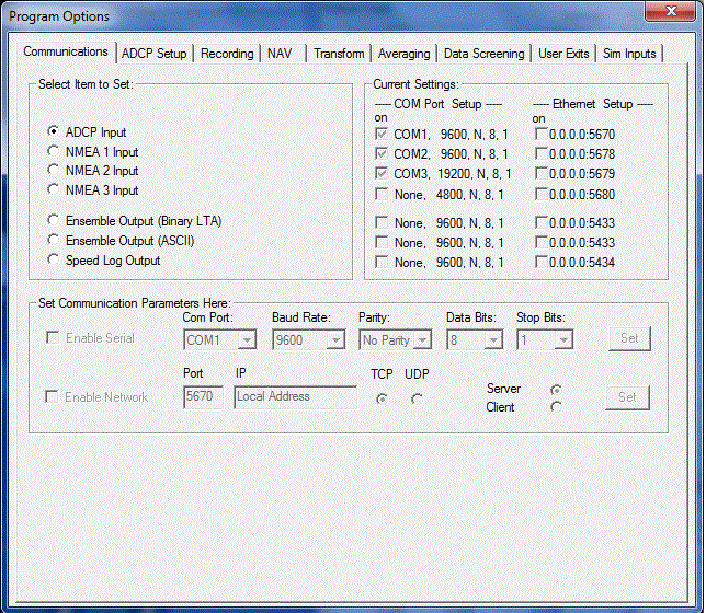
ADCP OS-75 Tidal Analysis
RV Celtic Explorer Cruise CE17-01
Chief Scientist: Kevin Sheehan, MI
July 22nd to August 6th 2017
John E. Hughes Clarke
Anand Hiroji
Jose Cordero Ros
Center for Coastal and Ocean Mapping
University of New Hampshire
Contents:

Overview:

While not a primary mission for INFOMAR, all ancillary data that can be collected is encouraged. To that end, the Ocean Surveyor 75 kHz ADCP that is installed on the drop-keel was logged for the whole CE17-01 mission. The OS-75 in narrow band mode capable of measuring currents down to over 600m depth using 16m bins. In this shelf utilization, however, it was configured in broadband mode to use 8m bins with bottom tracking enabled. 

With a drop keel depth of ~ 8 m and a blanking distance of another 8m, the shallowest current velocity obtained was at 16m. The thermocline was generally between 25 and 50m depth.  Thus just the first two bins were used to estimate velocities in the upper mixed layer. And the greatest depth encountered were about 130m. Bins below 50m were used to estimate the sub-thermocline circulation, taking care not to include bottom contaminated velocities.

The data presented here is from the short-term-averaging (STA) ensembles. This was set to 120 seconds. At a typical ship speed of 8 knots this corresponded to a solution spacing every 480m. Typical lines were 2 hours long for the first half of the cruise and then 3 hours long for the second half. Thus the tidal phase changed significantly over the length of a single line.  During the 2 week mission, the tidal range changes from springs to neaps. As the tides here are dominated by the M2 signature, the data were sorted into 24 bins covering the 12.42 hour period of the M2 wave (i.e. about 30 minutes per bin). Thus, a typical survey line was broken up into 4 or 6 tidal phase windows. In this manner the variation of the tidal ellipse over the M2 cycle could be assessed across Labadie bank and above and below the thermocline.

The expected tidal current activity was an ellipse with the semi-major axis aligned from SW to NE. This is in accordance with the output of the Webtide implementation of the FES2004 model (see animation below - which is running backwards).  The tidal vector around Labadie Bank are expected to cycle in a clockwise manner.


HR global M2 ellipses
WebTide HRGlobal output of the M2 tidal ellipse patterns in the Celtic Sea
(note animation is backwards - the ellipse rotation is actually clockiwide in the Celtic Sea.)

Preliminary OS-75 data results:

The data are acquires using VMDAS. The short term averages (2 minutes) are then read into WinADCP and there is a choice of reference - either ship's navigation or bottom tracking. As there is doubt about the exact alignment of the ADCP quad element, the bottom tracking was used. The preliminary results, illustrated below for the depth range 50-75m (below the thermocline), seem very believable.


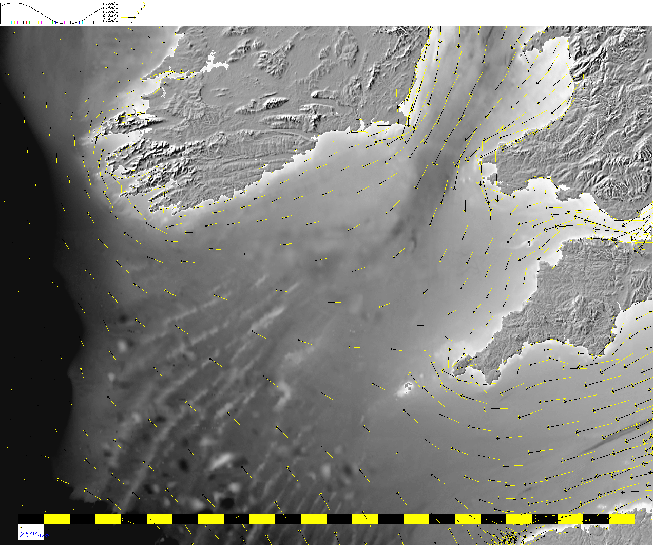
Data as acquired on a line by line basis
Note that the lines are 2-3 hour long so the azimuth and magnitude
of the tide changes over that period.
Data as re-sorted in 24 bins around the M2 tidal phase.
equivalent to approximately 30m minute windows
adcp as
                acquired
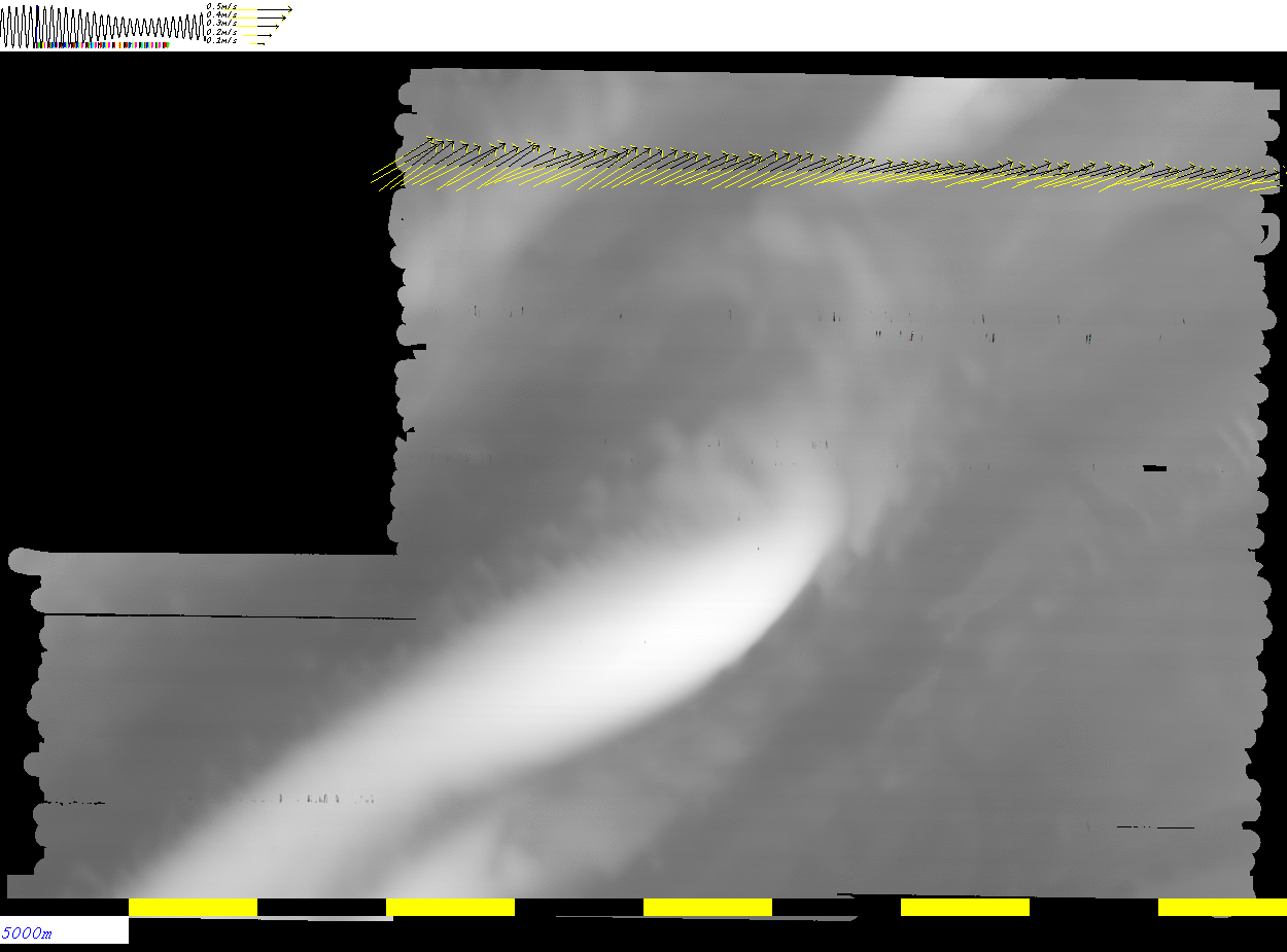
One can see the transition from larger tidal vectors during
the spring tides which occurred while the vessel was on
the north half of the bank, to the weaker currents
during neaps on the southern half of the survey.
sorted
                tides
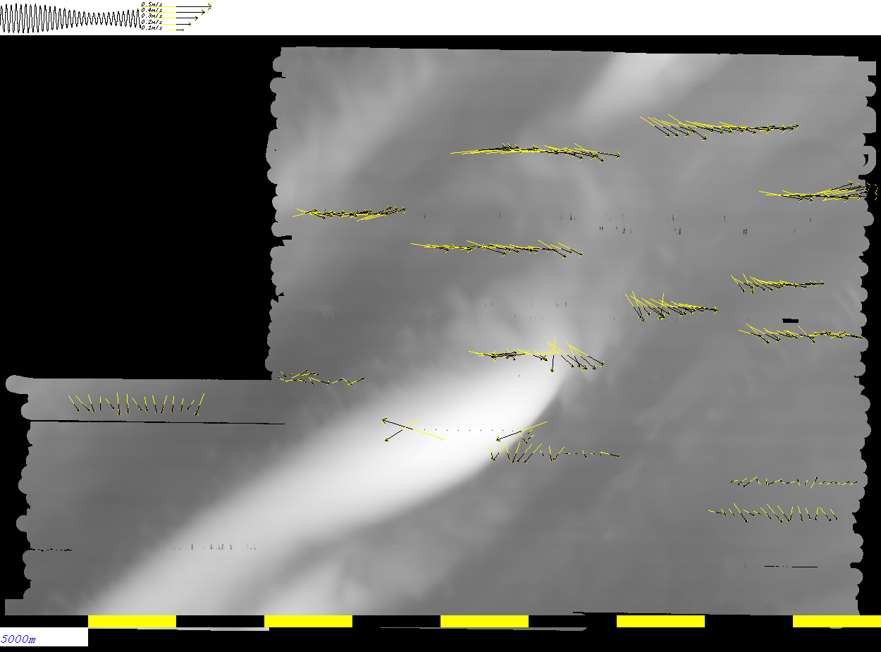
One can clearly see the clockwise rotation of the tidal vectors
over the M2 period. Note that the long axis of the tidal ellipse
is approximately aligned with the long axis of Labadie Bank.


ADCP Setup:

The following file : JHC_CE1701_Options_B_bottom_track.ini should be a saved configuration for the OS75 as used for most of the survey.  The first 10 lines actually used : JHC_CE1701_Options_A.ini  which did not have bottom tracking enabled.

This setup was to have 8 m bins, 30 of them (250m max) and with bottom tracking enabled.  The mistake I think I made was to leave the "Signal Processing Mode" in "low-res". I think this means Narrowband, whereas I wanted Broadband ("high res - shallow water").  The strange thing is, when the data are exported through WinADCP it claims it is broadband?.

What I would like to try out for the second leg is this configuration: JHC_CE1701_Options_C_BB_4m_bins_bottom_track.ini  which involved switching to broadband, reducing the binsize to 4m (and increasing the # of bins to 50 to get to 200m to cover the whole shelf).


Here are screen grabs of all the settings as was used in this leg for the available options:

sg sg sg sg
sg sg sg sg
sg
sg


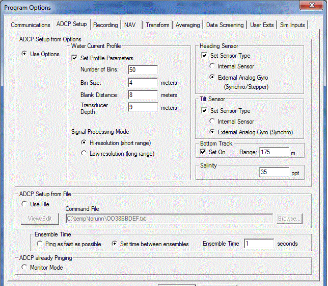
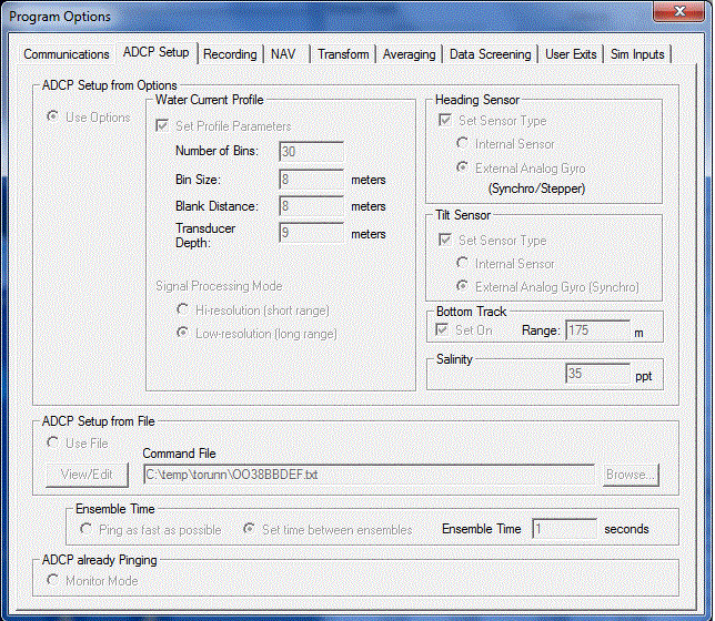
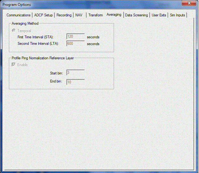
<<<<<
what I think screen 2
(ADCP setup) should
have been
<<<<<

For the second leg, it would be worth trying this other option out. To test it, you can export the data through winADCP as ASCII using this instruction document: and send me the data and I can compare it.


page composed offshore --  JEHC