animation of 600 kHz volume backscatter imagery showing intrusion into the Kennebecasis
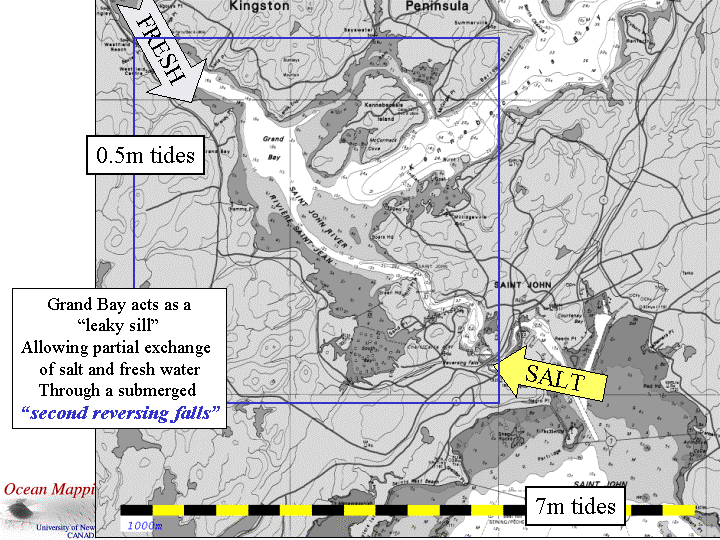
Grand Bay Sill
June 13th and 19th, 2003
animation of 600 kHz volume backscatter imagery showing intrusion into the Kennebecasis |
Salt
Water Intrusion Dynamics Grand Bay Sill June 13th and 19th, 2003 |
|
John
E. Hughes Clarke and Anya
Duxfield
Ocean Mapping Group Dept. Geodesy and Geomatics Engineering University of New Brunswick Canada |
Marion Sutton ISITV Ocean Engineering University of Toulon France |
 As
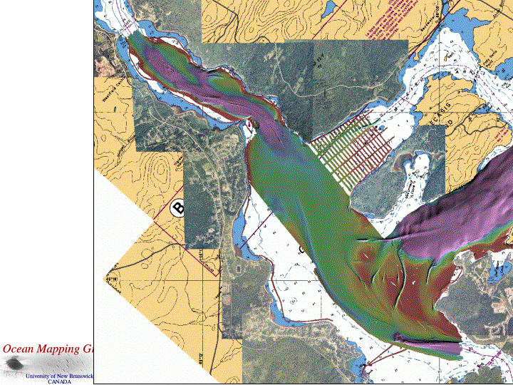
a result of multibeam operations over the the past 5 years
(2000-2004) the major bathymetric extent of this region has been mapped
(fig. left) with a spatial resolution of ~ 1m using 300 kHz multibeam
sonars (a
Simrad EM3000S). The bathymetric imagery, clearly indicate widepread
erosional and depositional patterns on the sill top and adjacent
channels, most probably related to the modern exchange of saline waters
between the deeper basins.
As
a result of multibeam operations over the the past 5 years
(2000-2004) the major bathymetric extent of this region has been mapped
(fig. left) with a spatial resolution of ~ 1m using 300 kHz multibeam
sonars (a
Simrad EM3000S). The bathymetric imagery, clearly indicate widepread
erosional and depositional patterns on the sill top and adjacent
channels, most probably related to the modern exchange of saline waters
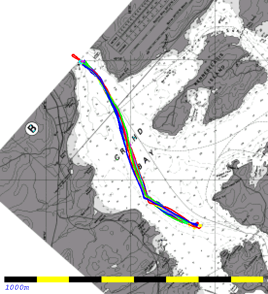
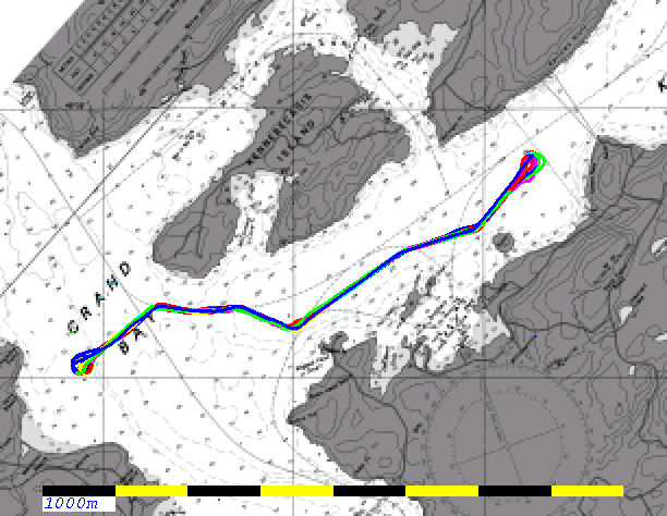
between the deeper basins. 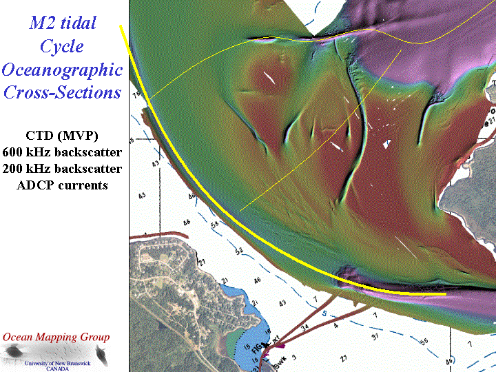 Looking
now in detail at the sill top (fig. right) we see that there are
multiple
potential pathways for water to flow between the Grand Bay channel and
the deeper basin of the Kennebecasis. This area has been the
focus of a variety of experiments in 2000 and 2001, but now with the
availability of newer instrumentation (primarily the Brooke Ocean
MVP-30) we have an opportunity to better examine the dynamics of that
exchange.
Looking
now in detail at the sill top (fig. right) we see that there are
multiple
potential pathways for water to flow between the Grand Bay channel and
the deeper basin of the Kennebecasis. This area has been the
focus of a variety of experiments in 2000 and 2001, but now with the
availability of newer instrumentation (primarily the Brooke Ocean
MVP-30) we have an opportunity to better examine the dynamics of that
exchange.
|
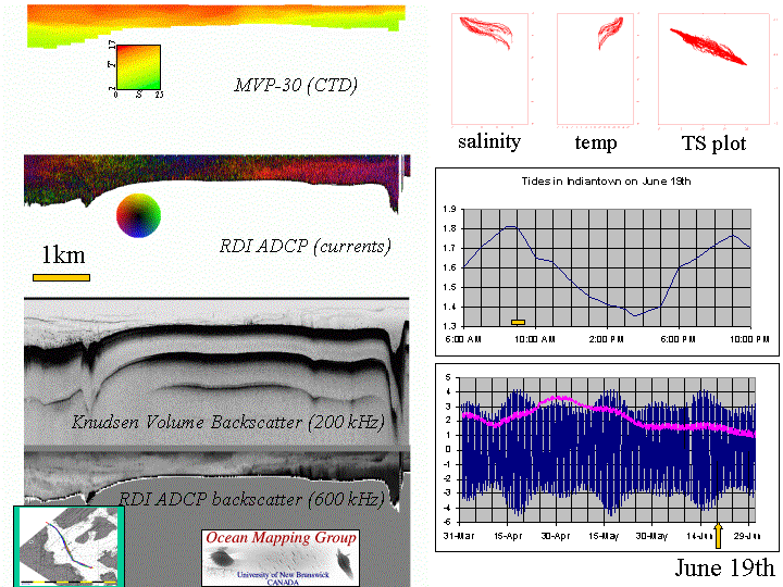
The adjacent animation
illustrates a variety of simultaneous views of the exchange of salt and
fresh water between the gorge, upstream of the Reversing Falls
and the Westfield Channel, on the way up river to Long Reach. 20 images
are presented representing 20 cross-sections of the ~7000m section. For each section (indicated by phase of tide at Indiantown, 1500m away just above the Reversing Falls), all the salinity and temperature profiles are presented in a conventional plot together with a TS plot showing the mixing line between the two masses. Four images are presented:
In this imagery one clearly sees the salt water intrusion develop in the gorge, and spread out upstream over the sill as a basal density flow, just (if perhaps not quite) making it into the deeper water of the Westfield channel at it maximum upriver extent by ~ half way through the ebb. From then on, the surface waters are flowing out and there is a slow leakage of the residual salt water layer at the base, back into the gorge (as seen better in the 2000 imagery, where an interfacial waterfall actually develops as it flows backwards). |
|
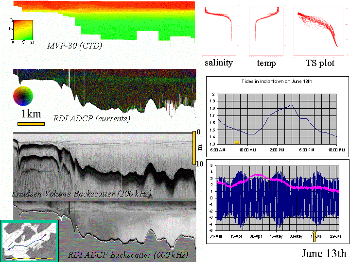
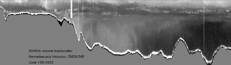
The adjacent animation
illustrates a variety of simultaneous views of the exchange of salt and
fresh water between the main SE-NW through-channel in Grand Bay and the
Kennebecasis Fjord to the NE. The section chosen, actually passes
through the deepest lateral spill channel that lies just S of
Kennebecasis Island. That channel is assumed to be the major conduit
for most of the saline inflow into the Kennebecasis (although we also
know that smaller sill top channels play a surprisingly significant
role). The display parameters are identical to the above case, and again 20 sections were acquired over a 12.42 hour cycle period. In this case we are looking for evidence of an interfacial hyperpycnal intrusion between the overlying freshwater and the underlying plug of relatively stagnant salt (23ppt) water. As we can see, the halocline in the Kennebecasis is significantly perturbed (> 5m) as a result of the progression of the intrusion. The magnitude of the halocline perturbation decays ~ linearly to the NE as one goes into the fjord. This "internal tide/wave" of M2 period was actually previously noted by Page (BSc Hons thesis 1980's) from a series of point observations close to the line of this transect. What is new here, is evidence for the progression of that wave into the fjord. Of particular interest is evidence for the hyperpycnal intrusion . We can see evidence of a mid water current maximum as well as a clear right ward (NE ward) propagating head running along the location of the primary acoustic scattering horizon (that represents closely the pycnocline). In the 600 kHz it almost seems that a shock wave actually propagates into the lower more stagnant waters. The nature of this remarkable volume scattering signature in not understood. |