|
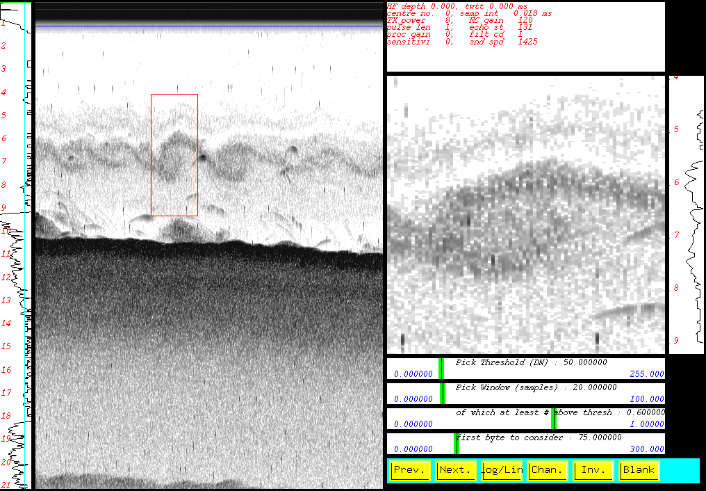
200 kHz acoustic volume scattering
image
of Kelvin Helmholtz
waves on salt-fresh interface
(Oakpoint, Long Reach,
Saint John River)
|
GGE 5013 - Oceanography for Hydrographic Surveyors
September 2008
John E. Hughes Clarke
Ocean Mapping Group
Dept. Geodesy and Geomatics Engineering, UNB
http://www.omg.unb.ca/GGE/GGE5013_Current.html
|
Taught by:
GGE 5013:
John Hughes Clarke (jhc@omg.unb.ca) -
453-4568
(office - E32) - 449-0785 (cell)
Coastal and
Continental Shelf Oceanography 12 classes ....
Tides and
Water
Levels - 12 classes....
Prerequisites - or - Corequisites:
GGE 3353 (first 4 intro
oceanography
- marine geology classes and single tides classs)
LEARNING OBJECTIVES
- Understand principal controls on submerged bathymetry and
surficial
sediment
distribution so that decisions can be made on appropriate survey
instrumentation
and acquisition strategies.
- Understand principal controls on local oceanographic variability
so
that
appropriate survey tools and acquisition strategies may be designed
either
to:
- Measure those oceanographic variations (REA?s etc..)
or
- Minimise the impact of those variations on the quality of
acoustic measurements
(depth and bottom backscatter strength).
- Install a tide gauge and recover data for analysis
- Understand the astronomical theory of tides, and the harmonic
constituent
representation of tidal variations
- Understand physical causes & character of non-tidal water
level
variations
- Predict tide heights, reduce depth measurements using water level
records,
and perform water level transfers
- Intelligently use commercial software which incorporates some or
all of
the above theory and skills
Facets of Oceanography and Marine Geology that impact on
Hydrographic
Surveyors.
Hydrographic Surveyors have always had be aware of the physical
processes
that control the type and variability of both the watermass and seabed.
These media impact significantly on the performance of seabed survey
instrumentation.
Sea surface level is a variable that has to be quantified to bring
depth
observations to a defined datum, and surface seastate affects vessel
performance
and sonar-water coupling. The watermass controls the progagation
refraction
and attenuation of acoustic signals and the physical properties of the
seabed controls the reflection and backscattering of sound.
Historically, hydrographers have focussed primarily on the sea
surface
changes over tidal periods or longer. With the advent of heave sensors
and automated bottom detection, the higher frequency vertical motion
spectrum
became of interest (although there was little realisation about some of
the long term drifting issues with the early heave sensors). As sound
speed
probes have become more common, the bar check method has become less
used
and a continuous sound speed profile has replaced the single harmonic
mean
estimate for most (but not all) single beam operations. As oblique
sounding
has become the norm, the sensitivity of range/angle measurements to
refraction
has blossomed into one of the greatest challenges to precise
hydrography.
As such, a vastly increased interest in the spatial variability of the
temperature
and salinity characteristics of the watermass has arisen.
As swath sonars, used together with modern visualisation methods,
have
improved, our ability to recognise fine scale systematic artefacts in
the
data has increased. Shiptrack parallel and orthogonal ribbing and
ridging
is now easily visible at vertical scales of as little as 0.25% of the
water
column. Clients now perceive these all-to-apparent artefacts as
limitations
(even though they may be within survey specification). The modern
hydrographer
therefore, needs to be cogniscent of the shape of natural submerged
landscapes
(seascapes) so that they can rapidly assess the whether such artefacts
are present. Both the range and resolution capability of swath sonars
are
particularily sensitive to the bottom backscatter strength and thus the
surveyor must be aware of the likely natural variability in this
parameter.
Surveyors should thus also be cogniscent of the likely variability in
surficial
sediments (which control the bottom backscatter strength) in an
area
within which they are intending to survey.
This course is designed to describe the physical processes in the
marine
environment that are of interest to the hydrographic surveyor. A
limited
field program involving the measurement of critical oceanographic
parameters
(tides, currents, temperature and salinity and surfical sediments) will
take place in the lower Saint John River Estuary to demonstrate the
practical
aspects of observing these parameters.
CLASS
DESCRIPTIONS
12 Oceanography-
Marine
Geology Sessions
12 Tide - Vertical
Datum Sessions
PRACTISE
- Gauge
Establishment
- Tide
Measurements and Sounding Reduction
- Currents
Measurement and analysis
TIMETABLE 2008
The course will be given as a series of lecture/discussion periods
on
:
Tuesday 0830
-1000 E-16
Thursday 0830 - 1000 E-16
And including an extrea 1 hour time slot for visting lecturers and
scheduling mismatches:
provisionally 1500 -1600 on Fridays in E16
The course will be broken into two main sections:
Coastal Oceanography
and Sedimentology - First
Half of Term
Tides and Water Levels -
Second Half of Term
Note first class for 2008 is Thursday
the 4th of September.
| Sunday |
Monday |
Tuesday |
Wednesday |
Thursday |
Friday |
Saturday |
Comments |
31st August
|
|
|
|
Intro Class
|
|
|
|
7th September
|
|
OC class 1
|
|
OC class 2 |
|
|
LAB
1:
|
14th
|
|
OC class 3
|
|
OC class 4 |
|
|
Oceanography |
21st
|
|
OC class 5 |
|
OC class 6 |
|
|
|
28th
|
|
OC class 7 |
|
OC class 8 |
|
|
LAB
2:
|
5th October
|
|
OC class 9 |
|
OC class 10 |
|
|
Geology
|
12th
|
THANKSGIVING |
OC class 11 |
OC class 12 |
JHC away
|
|
|
|
19th
|
|
TIDES class 1 |
|
TIDES class 2 |
|
|
|
26th
|
|
TIDES class 3
|
|
TIDES class 4
|
|
|
LAB
3: |
2nd November
|
|
TIDES class 5 |
|
TIDES class 6 |
|
|
Tides
|
9th
|
TIDES class 7 |
REMEMBRANCE |
|
TIDES class 8 |
|
|
|
16th
|
|
TIDES class 9 |
<< IAN
|
TIDES class 10 |
<< IAN
|
|
JHC AWAY
|
23rd
|
|
TIDES class 11 |
<< SUE
|
TIDES class 12 |
<<SUE
|
|
JHC AWAY
|
30th
|
|
Spare Slot
|
LAST DAY OF
CLASSES |
|
|
|
TAKE-HOME EXAM
|
7th December
|
|
|
|
|
|
|
|
Field Laboratory Program
5013 students have to do 3 labs in 2008:
LAB
A 2006
- MVP Analysis in the Bay of Fundy
LAB
A 2007/8
- MVP Analysis off the Scotian Shelf
LAB
B 2007/8
- Geologic (multibeam and subbottom) Analysis off the Scotian Shelf
Also feel free to ask questions at anytime, either by
email : (
jhc@omg.unb.ca
) or in person.
COURSE
ASSESSMENT
ASSESSMENT
Assessment is based on 3 practical exercises (lab reports) and a take
home exam.
Final (take home) exams 25%
Lab exercises 3 x 25 = 75%
MARKING: Letter grades are assigned for
each of above course segments.
Numerical marks are converted to letter grades according to
| 0-44 |
45-49 |
50-54 |
55-59 |
60-64 |
65-69 |
70-74 |
75-79 |
80-89 |
90-100 |
F
|
D
|
C
|
C+
|
B-
|
B
|
B+
|
A-
|
A
|
A+
|
Course mark is
determined as follows: letter grades are converted
to grade points as listed below:
|
0
|
1
|
2
|
2.3
|
2.7
|
3
|
3.3
|
3.7
|
4
|
4.3
|
Final course grade point is the weighted average of course
segment grade points, using above weights for each course
segment. Final course grade point is converted back to letter
grade.
REFERENCE MATERIAL
Most of the following are available either in the UNB Engineering
Library or the GGE hydrography library (Room E16)
Material available on World Wide Web sites (see
list)
Forrester, W.D. (1983). Canadian Tidal manual.
Bowditch (2002). American Practical Navigator,
Vol 1.
Ingham, A.E. ed. (1975) Sea surveying.
Wiley
Ingham, A.E. (1984) Hydrography for the
surveyor and engineer. 2nd ed
Royal Navy (1965) Admiralty manual of
hydrographic surveying
Lisitzin, E. (1974). Sea-level changes.
Elsevier
Open University (1978). Oceanography Course
OA419 Coastal and Shelf Sea Oceanography :Convenors: Dr.
Peter Statham & Dr
Jonathan Sharples
http://www.soes.soton.ac.uk/teaching/courses/oa419/oa419.html
OA311
shelf sea and shelf edge dynamics. Dr. Jonathan Sharples
http://www.soes.soton.ac.uk/teaching/courses/oa311/oa311.html
Matthias Tomczak, 2000, An Introduction to
Physical Oceanography,
http://www.es.flinders.edu.au/~mattom/IntroOc/index.html
Matthias Tomczak, 2000, Shelf and Coastal
Oceanography
http://www.es.flinders.edu.au/~mattom/ShelfCoast/index.html
Pickard, G.L. and Emery,W.J., 1982, Descriptive
Physical Oceanography: 4th Edition, Pergamon Press.
Pond,S. and Pickard,G.L., 1983, Introductory
Dynamical Oceanography, 3rd Edition, Pergamon Press
SAMPLE
MIDTERM AND FINAL QUESTIONS
Note all samples are WORD documents
Final Questions
last modified by John E. Hughes Clarke
(jhc@omg.unb.ca) Autumn 2008