
Project Overview
The Squamish Prodelta experiment is ultimately designed to test the limits to which real seabed morphologic change can be detected using integrated multibeam sonar systems. The experimental objectives are twofold:
- to detect and understand the extent of, timing of, and mechanisms involved in, seabed mass wasting on the prodelta
- to improve acoustic imaging methods to the point where such
processes can be observed adequately.
 The Ocean Mapping Group (OMG) at
UNB specializes in developing improved methods for survey, processing,
analysis and presentation of seabed mapping information, primarily
through the use of integrated multibeam sonar systems. To that end,
research topics in positioning, orientation, integration, refraction,
seabed backscatter and water column imaging are continually undertaken.
As part of these developments, the OMG undertake field mapping programs
to support these engineering research aims. Those programs provide an
opportunity to test out and improve these research developments. The
largest program is the CCGS Amundsen Arctic
Archipelago Seabed Mapping> Program. The most flexible program,
however, revolves arounds the operation of the CSL Heron with her
CFI-funded suite of positioning and acoustic sensors. The Squamish
Prodelta Program utilizes the CSL Heron and is an opportunity to apply
research developments directly to questions about seabed sedimentary
processes.
The Ocean Mapping Group (OMG) at
UNB specializes in developing improved methods for survey, processing,
analysis and presentation of seabed mapping information, primarily
through the use of integrated multibeam sonar systems. To that end,
research topics in positioning, orientation, integration, refraction,
seabed backscatter and water column imaging are continually undertaken.
As part of these developments, the OMG undertake field mapping programs
to support these engineering research aims. Those programs provide an
opportunity to test out and improve these research developments. The
largest program is the CCGS Amundsen Arctic
Archipelago Seabed Mapping> Program. The most flexible program,
however, revolves arounds the operation of the CSL Heron with her
CFI-funded suite of positioning and acoustic sensors. The Squamish
Prodelta Program utilizes the CSL Heron and is an opportunity to apply
research developments directly to questions about seabed sedimentary
processes.Upper Howe Sound
 The
basin
under
investigation
is
the
upper
section
of Howe Sound north of
the Porteau Cove Sill. This sill is probably a terminal moraine and
separates the southern shallower section of Howe Sound from the deeper
northern section. Within this northern section, the fjord basin acts
like a natural laboratory for mass wasting studies, It is ~ 16 km long
and fed almost entirely by sediment input from the Squamish Delta.
Secondary sources of sediment have been input from the Britannia Beach
and Woodfibre locations, but volumetrically they are unimportant.
The
basin
under
investigation
is
the
upper
section
of Howe Sound north of
the Porteau Cove Sill. This sill is probably a terminal moraine and
separates the southern shallower section of Howe Sound from the deeper
northern section. Within this northern section, the fjord basin acts
like a natural laboratory for mass wasting studies, It is ~ 16 km long
and fed almost entirely by sediment input from the Squamish Delta.
Secondary sources of sediment have been input from the Britannia Beach
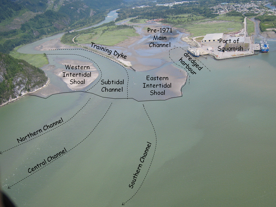
and Woodfibre locations, but volumetrically they are unimportant. The southern section of this upper basin is almost flat at a depth of about 285m, probably reflecting the ponding of distal turbidity currents originating from the Squamish prodelta slope to the north. A series of active and fossil prodelta channels are clearly visible in the multibeam surveys of the region. The fossil channels predate the installation of a training dyke in 1971. The active channels are the main focus of this survey.
The Squamish Delta Location
 The
Squamish
River
drains
a
watershed
within
the
Coast Mountain Range of
British Columbia and debouches at the head of Howe Sound. During the
summer freshet, a discharge of > 500m3/s is usually
maintained for a period of more than 4 months during which high
suspended sediment concentrations are present, and has resulted in the
development of a delta just west of the town of Squamish. Peak
discharge events of over 1000m3/s do occur within the
summer freshet. Notably however, even larger events (although of much
shorter duration) are common in the autumn due to local runoff.
The
Squamish
River
drains
a
watershed
within
the
Coast Mountain Range of
British Columbia and debouches at the head of Howe Sound. During the
summer freshet, a discharge of > 500m3/s is usually
maintained for a period of more than 4 months during which high
suspended sediment concentrations are present, and has resulted in the
development of a delta just west of the town of Squamish. Peak
discharge events of over 1000m3/s do occur within the
summer freshet. Notably however, even larger events (although of much
shorter duration) are common in the autumn due to local runoff.A training dyke, installed in 1971 has concentrated the full Squamish River discharge into a 500m section on the north west side of the fjord. The purpose was in part to be able to create the Squamish Port facility. Prior to the dyke, the main river flow actually ran through the current port facility location and, prior to 1921, actually flowed through what is now termed the Mamquam Blind Channel. Since installation of the dyke, the delta top has prograded several hundred metres to the south and now extends out partially cutting off the entrance to the port. Howe Sound is a macrotidal fjord. The tidal range varies from about 5m during Springs to 3m during Neaps.
The delta top consists of two intertidal sand flats that are developed on either side of the main subtidal river/estuary channel The river channel is deepest immediately adjacent to the training dyke with a depth of ~2-3m below chart datum. As the channel extends beyond the training dyke it shoals and widen slightly as it approaches the delta lip. At the lip, the channel is about 200m wide and less than a metre below chart datum. During the winter-time low discharge period, the salt water of Howe Sound penetrates up the river, forming a seasonal estuary extending several kilometres upstream. During the freshet, the salt water is effectively expelled from the river.
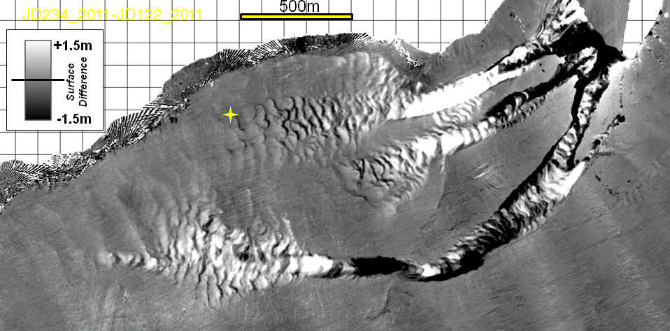
Morphology of the Prodelta Slope
Seaward of the lip of the delta, the prodelta slope extends over 2000m and drops down to more than 180m depth. Superimposed on that slope are several prominent channels. Based on biannual, annual and semi-annual multibeam surveys over the past 6 years, three major conduits are noted to be currently active. They are herein termed the northern,
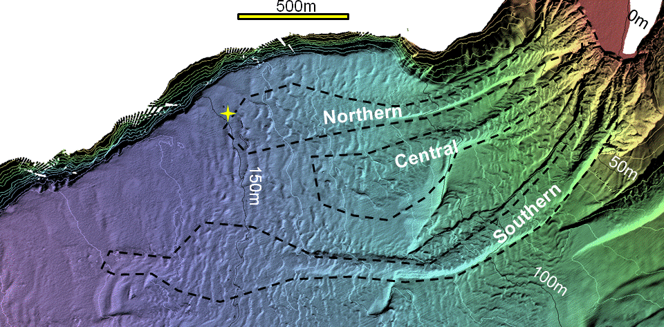 central
and southern channels. They have been the focus of the 2011 experiment
which involved daily resurveys of these three channels to look for
evidence of activity.
central
and southern channels. They have been the focus of the 2011 experiment
which involved daily resurveys of these three channels to look for
evidence of activity.Southeast of the active delta is a pair of relict channels. The oldest one extends from the mouth of the Mamquam Blind Channel and, although predominantly buried, clearly used to have an incised meandering
 character. The younger one drained from the location of the current
port facilty and was presumably the main active channel prior to 1971.
Since the dyke installation it is clear that it has been completely
abandoned and is being swamped by overbank sedimentation.
character. The younger one drained from the location of the current
port facilty and was presumably the main active channel prior to 1971.
Since the dyke installation it is clear that it has been completely
abandoned and is being swamped by overbank sedimentation.The net change in the prodelta morphology from April to August 2011 is presented in the figure to the left. As can be seen the three main channels were indeed the loci of activity. The yellow star indicates the location of the bottom mounted ADCP (see discussion later), which was installed to detect turbidity current events. As can be seen it was right on the edge of the region of detectable change. The instrument was in fact buried by one flow for a period 20 days.
Daily Seabed Change Detection
While the figure above illustrates the cummulative change over the summer, there remains a question about the scale of individual
 mass
wasting
events
and
their
periodicity.
For that purpose, the resurvey
frequency was designed to establish change over a 1 or 3 day period
(every weekday).
mass
wasting
events
and
their
periodicity.
For that purpose, the resurvey
frequency was designed to establish change over a 1 or 3 day period
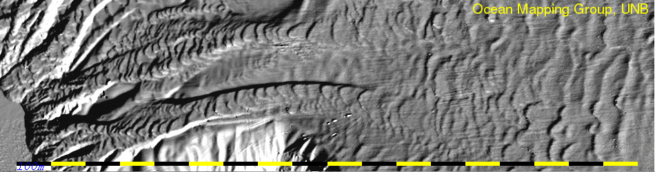
(every weekday). The animation to the right shows the seafloor the day before and the day after one of the largest mass wasting events. As can be seen there is a clear shift in the transverse bedforms patterns on the channel floor. The difference map, highlights the location of the change.
The animation at the head of this report shows the daily evolution of the morphology of the lip of the delta and the prodelta slope immediately below. As can be seen, the events were intermittent, with pauses of several days between activity at times. During the peak activity however, daily events were common with a clear net upslope migration of those channel-transverse features. Also one can see the lip of the delta active prograding as a result of rapid dumping of suspended sediment as the flow decelerates off the lip of the delta. The apparent noise in the data is largely sonar mistracking on the gas plumes that were strongly but ephemerally developed on the prodelta slope.
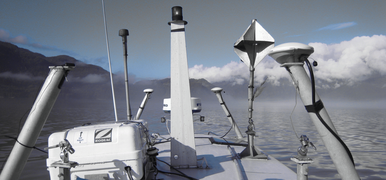
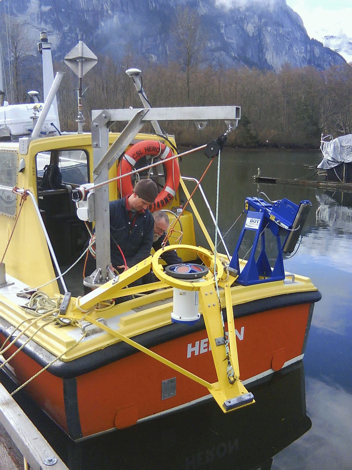
CSL Heron and her instrumentation
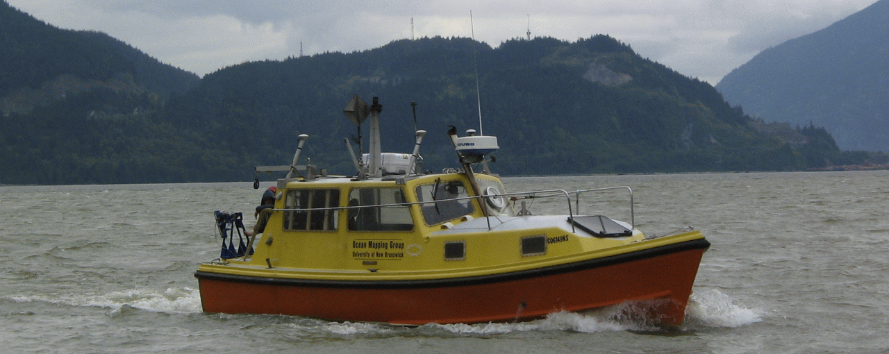 CSL
Heron
is
a
10m
H-class
survey
launch on loan to UNB from the Canadian
Hydrographic Service.
From 2002 until 2009 she operated with a suite of
instruments centred around a 300 kHz multibeam sonar (EM3002). During
that time she supported OMG research
CSL
Heron
is
a
10m
H-class
survey
launch on loan to UNB from the Canadian
Hydrographic Service.
From 2002 until 2009 she operated with a suite of
instruments centred around a 300 kHz multibeam sonar (EM3002). During
that time she supported OMG research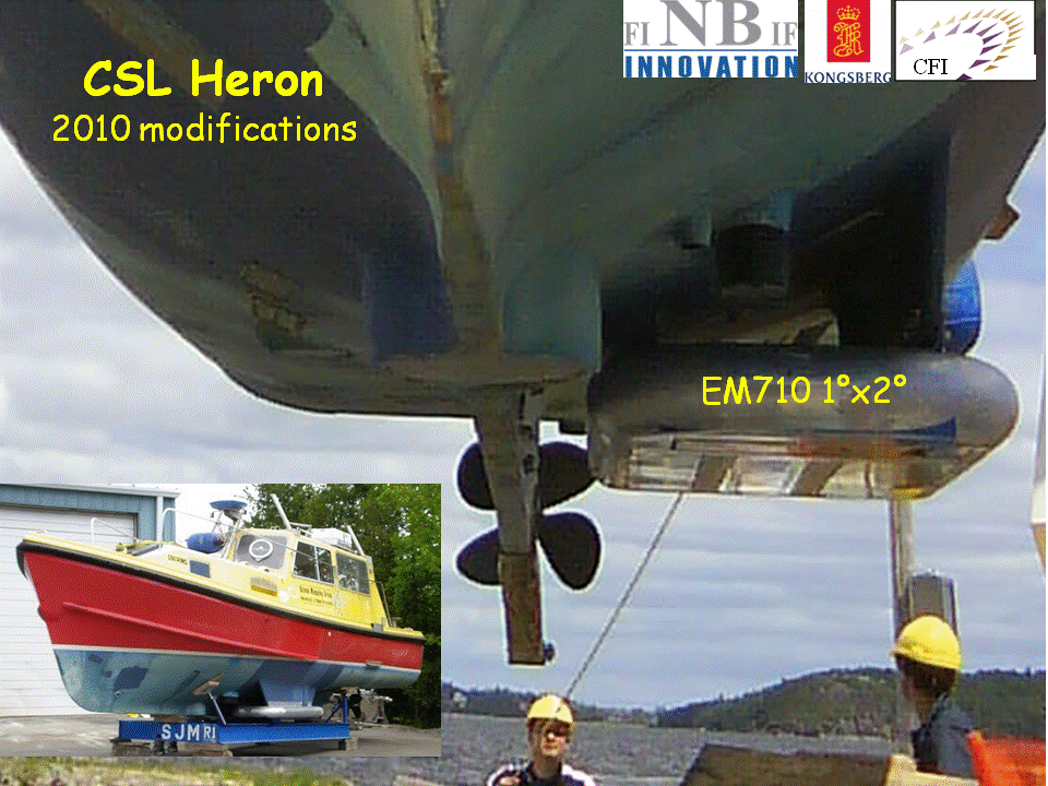 objectives in New Brunswick
coastal waters and the Canadian Arctic Archipelago (deployed from CCGS
Amundsen and CCGS Henry Larsen). In 2010 she was upgraded to a
newer suite of instrumentation centred around a 70-100 kHz multi-sector
multibeam sonar (EM710). It is this configuration that
has been used for the Squamish prodelta experiment.
objectives in New Brunswick
coastal waters and the Canadian Arctic Archipelago (deployed from CCGS
Amundsen and CCGS Henry Larsen). In 2010 she was upgraded to a
newer suite of instrumentation centred around a 70-100 kHz multi-sector
multibeam sonar (EM710). It is this configuration that
has been used for the Squamish prodelta experiment. The EM710 is ideal for imaging not just the seabed over the range of depths (0-285m), but has sufficient signal to noise left at those slant ranges to provide useful water column imagery of the scattering field. In addition to the mapped seabed morphologic change, the identification of gas plumes and active water body intrusions, using the water column imagery was an unexpected highlight of the experiment.

The Heron is both a research platform and a training platform for graduate students. The Squamish prodelta program forms the basis for 2 PhD and 3 MScEng theses. She can take a full complement of 6 persons, athough for typical survey operations, the skipper and two surveyors are the usual load. From the Heron we can also undertake oceanographic surveys (see below) and deploy current meters.
Positioning Issues
 The
fidelity
of
the
apparent
surface
difference
maps
depends on the
component uncertainties in the integrated mapping system. As part of
this, the horizontal
The
fidelity
of
the
apparent
surface
difference
maps
depends on the
component uncertainties in the integrated mapping system. As part of
this, the horizontal 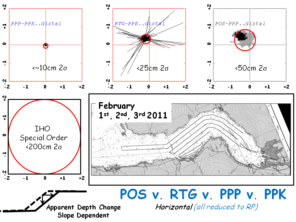 and
vertical
accuracies
need
to
be
assessed.
Flavours of GPS including: Inertially smoothed DGPS, RTG, PPP and PPK
have been explored. These provide horizontal positioning accuracies in
the range of metres, decimetres and centimetres. Vertically, the PPP
and especially the PPK solutions allow us a few or a single decimetre
level uncertainty (95%).
and
vertical
accuracies
need
to
be
assessed.
Flavours of GPS including: Inertially smoothed DGPS, RTG, PPP and PPK
have been explored. These provide horizontal positioning accuracies in
the range of metres, decimetres and centimetres. Vertically, the PPP
and especially the PPK solutions allow us a few or a single decimetre
level uncertainty (95%).Such levels of achievable 3D positioning accuracy have to be combined with a matching level of offset and alignment surveys to integrate the antenna solutions with the sonar-relative angles and ranges.
Any horizontal positioning biases, will show up on the steep delta front as false apparent depth changes when one survey is compared to another. Thus one of the geomatics research aims of this program, is to minimise these 3D positioning errors so that the natural change in the morphology can be best observed.
Oceanographic Observations
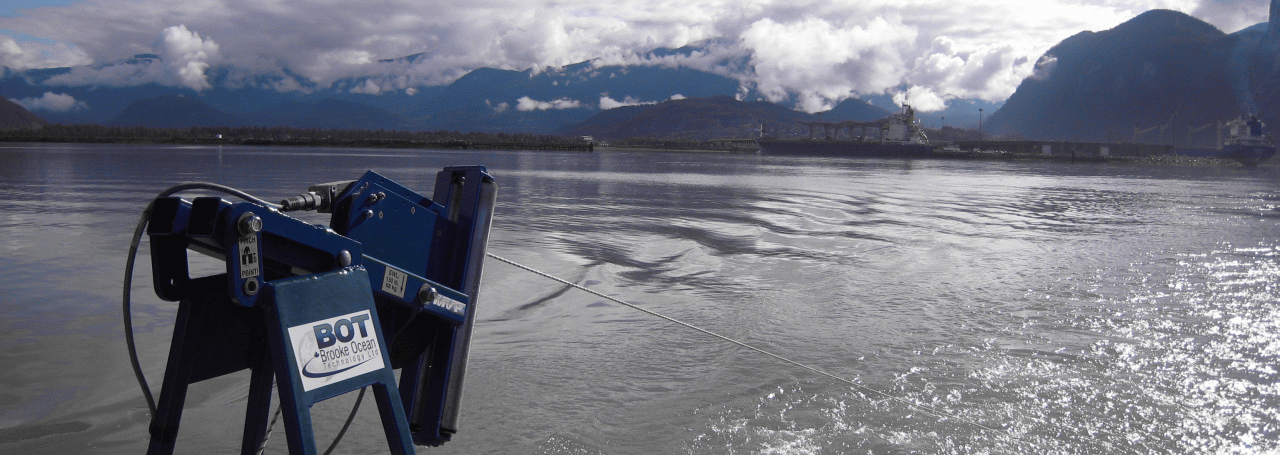 A
river
mouth
emptying
into
a
macrotidal
salt
water body represents an area of highly
dynamic
oceanography. The mixing of salt and fresh water,
A
river
mouth
emptying
into
a
macrotidal
salt
water body represents an area of highly
dynamic
oceanography. The mixing of salt and fresh water,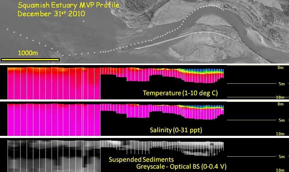 modulated by the
basin and delta-top morphology, the tides and the variable river
discharge result in rapid spatial variations in sound speed (a function
of temperature and salinity). The sounds speed variability in turn,
affects the accuracy of the range and angles derived from the sonar
system.
modulated by the
basin and delta-top morphology, the tides and the variable river
discharge result in rapid spatial variations in sound speed (a function
of temperature and salinity). The sounds speed variability in turn,
affects the accuracy of the range and angles derived from the sonar
system. To address this, a rapidly cycling, towed CTD sensor was deployed (a Brooke Ocean MVP) which, through the use of longitudinal sections, allowed us to look at the the temporal and spatial variability of the estuarine mixing around the delta mouth.The figure to the right illustrates a temperature, salinity and optical backscatter section along the Squamish river estuary, extending about 2000m upstream from the lip of the delta. These sections were obtained twice weekly. Additional sections through the river plume and along the length of the fjord to Porteau Cove were obtain on a similar sampling scale.
Bottom Mounted ADCP Observations.
To directly detect the presence of turbidity current activity, an acoustic doppler current profiler (ADCP) was deployed in
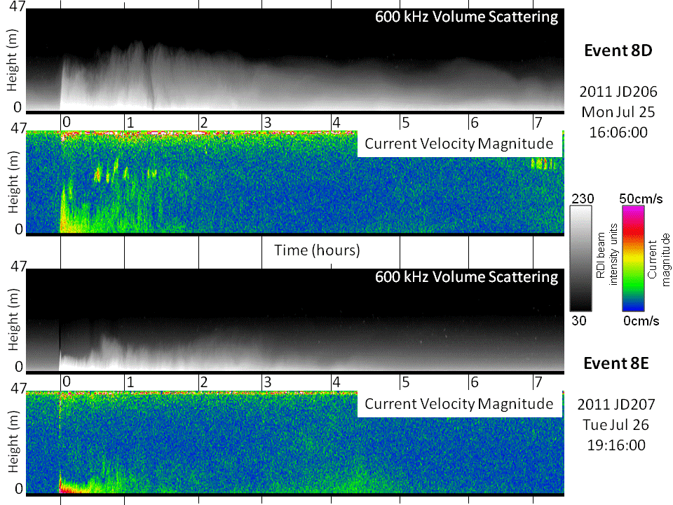 150m+
of
water
immediately
downstream
of
the terminus of the northern
channel. The aim was to record current and suspended sediment surges
that might result from the slump events events apparent from the
morphological change seen upslope.
150m+
of
water
immediately
downstream
of
the terminus of the northern
channel. The aim was to record current and suspended sediment surges
that might result from the slump events events apparent from the
morphological change seen upslope.Twenty discrete turbidity current events were indeed detected. They were characterized by peak velocities of up to 1.5m/s (more typically 0.5m/s) for a duration of over an hour. The turbid plumes were seen to ascend up to 40m above the seabed and be detectable for more than 8 hours after the nose of the event passed..
Two example events are illustrated in the figure to the right.
Water Column Imaging of Hyperpycnal Intrusions

Using multibeam acoustic imaging of the volume scattering in the water mass we are able to detect whether the deep scattering layer, developed in the fjord, was perturbed by intrusive events. Every day, transects were run along the three channel axes. The hope was that intrusive activity could be detected and correlated with the observed morphologic change and the turbidity current events. Several intrusions were indeed detected. Unless, however, the intrusion was still taking place at the time of the survey (usually a 45 minute window), there may be no evidence of the events that caused the morphologic change within the 24 hour window between the previous and this survey.
An optical backscatter probe was lowered into the channel axes, and evidence of enhanced suspended sediment levels were detected, correlated with intrusions, evidenced by the zooplankton displacement. At this time, the optical backscatter probe is not calibrated, so exact suspended sediment loads are not yet known…
Publications:
- Hughes Clarke, J.E., S. Brucker, J. Muggah, I. Church, D.
Cartwright, P. Kuus, T. Hamilton, D. Pratomo and B. Eisan, 2012, The
Squamish ProDelta: Monitoring Active Landslides and Turbidity
Currents: Canadian Hydrographic Conference 2012, Proceedings, 15pp.
- Hughes Clarke, J.E., S. Brucker, J. Muggah, T. Hamilton, D.
Cartwright, I. Church and P. Kuus, 2012, Temporal
progression and
spatial extent of mass wasting events on the Squamish prodelta slope:
Landslides and Engineered Slopes:
Protecting Society through Improved Understanding – Eberhardt et al.
(eds) , Taylor and Francis Group, ISBN 978-0-415-62123-6,
p.1091-1096..
- Hughes Clarke, J.E., 2012, Optimal
use of multibeam technology in
the study of shelf morphodynamics: International
Association
of
Sedimentology, Special
Publication # 44,
Sediments, Morphology and Sedimentary Processes on Continental Shelves:
Advances in technologies, research and applications, Wiley, ISBN
978-1-4443-5082-1, p. 1-28.
- John E. Hughes Clarke, Steve Brucker, James Muggah, Ian Church,
Doug Cartwright, 2011, The
Squamish
Delta
Repetitive
Survey
Program:
A
simultaneous
investigation
of prodeltaic sedimentation and integrated system accuracy , U.S. Hydrographic Conference 2011. Proceedings,
http://thsoa.org/us11papers.htm,
16pp.
- Hughes Clarke, J.E., Brucker, S., Hill, P. and Conway, K., 2009, Monitoring
morphological
evolution
of
fjord
deltas
in
temperate
and Arctic regions: International
Conference
on
Seafloor
mapping for Geohazard Assessment, Editors: Chiocci F. L.,
Ridente D., Casalbore D., Bosman A, Rendiconti
online
della
SocietÃ
Geologica Italiana, Vol. 7, part 4, p.147-150
- Steve Brucker, John E. Hughes Clarke, Jonathan Beaudoin, Craig
Lessels, Kal Czotter, Ralph Loschiavo, Kashka Iwanowska and Phil Hill,
2007, Monitoring
flood-related
change
in
bathymetry
and
sediment
distribution
over the
Squamish Delta, Howe Sound, British Columbia United States Hydrographic Conference 2007.
http://thsoa.org/us07papers.htm, 16 pp.
- Gordon Allison – skipper CSL Heron (CCG retired)
- John E. Hughes Clarke
- Steve Brucker
- James Muggah
- Ian Church
- Doug Cartwright
- Travis Hamilton
- Pim Kuus
- Danar Pratomo
- Brad Eisan
page maintained by JEHC