
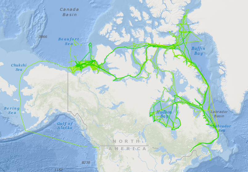
The Ocean Mapping Group Arctic Mapping Campaign
The Ocean Mapping Group’s role from 2003 to 2013 was to test the CCGS Amundsen‘s acoustic equipment and collect as much depth, backscatter and sub-bottom data as possible throughout the Canadian Arctic. The primary purpose being to build up coverage with each transit through the passage. Data collected from the lengthy transits and planned surveys will allow scientists, hydrographers and the general community to better understand the Arctic seabed morphology and improve navigational safety. Each year, collected data is processed and made available on-line to all interested parties, whether involved with the ArcticNet project or not, in numerous formats.
In 2012 and 2013 a similar initiative was started on the RV Nuliajuk to map the seafloor throughout Southeast Baffin Island. The primary purpose again being to build up coverage with each transit, improve navigation corridors to the Northern communities, study sea level history, geohazards, and marine habitat mapping.
Map Products
NOAA NCEI
CCGS Amundsen multibeam sonar data collected by the Ocean Mapping Group is now available through the NOAA National Centers for Environmental Information (NCEI): https://maps.ngdc.noaa.gov/viewers/bathymetry/. To view the Amundsen data, click “Search Surveys” and choose “Amundsen” as the platform name.
Arctic
- Google Maps ArcticNet Interface, 2003-2013 Follow this link to view processed bathymetry and backscatter data gathered by the EM300 and EM302 onboard the CCGS Amundsen and EM3002 data onboard the M/V Nuliajuk.
- ArcticNet 15’x30′ Basemap Series, 2003-2013 Follow this link to view processed bathymetry and backscatter data gathered by the EM300 and EM302 onboard the CCGS Amundsen and EM3002 data onboard the M/V Nuliajuk.
- Transit Data, 2003-2013, in strip map format Follow this link to view processed bathymetry, backscatter and sub-bottom data gathered by the EM300, EM302 & 3.5kHz transducer array onboard the CCGS Amundsen.
South East Baffin Island
- Google Maps SE Baffin Island, 2012-2014 5m Resolution bathymetry and backscatter tiles from the M/V Nuliajuk and CCGS Amundsen
- SE Baffin 15’x30′ Basemap Series, 2012-2014 5m Resolution bathymetry and backscatter basemaps from the EM3002 data onboard the M/V Nuliajuk
Beaufort Sea
- Beaufort Sea 2’x4′ Basemap Series, 2003-2010 Follow this link to view processed bathymetry, backscatter data gathered by the EM300, EM302, EM3000 and EM3002 onboard the CCGS Amundsen, CSL Heron, CCGS Nahidik, and CSL Petrel.
Metadata
- Metadata for the Ocean Mapping Group Arctic cruises
Cruise Overview
Papers
CCGS Amundsen: A New Mapping Platform for Canada’s North.
Published Lighthouse, Joural of the Canadian Hydrographic Association; Edition No. 65
Jason Bartlett, Canadian Hydrographic Service
Jonathan Beaudoin, Ocean Mapping Group
John Hughes Clarke, Chair, Ocean Mapping Group
Retracing (and Re-Raytracing) Amundsen’s Journey through the Northwest Passage.
Canadian Hydrographic Conference 2004
Jonathan Beaudoin, Ocean Mapping Group
John Hughes Clarke, Chair, Ocean Mapping Group
Jason Bartlett, Canadian Hydrographic Service
Hydrographic efficiencies of operating a 19 m research platform in the eastern Canadian Arctic.
Proceedings of the US Hydrographic Conference, New Orleans, 2013
Brucker, S., Muggah, J., Church, I., Hughes Clarke, J.E., Hamilton, T., Hiroji, A., Renoud, W.
Ocean Mapping Group