

Oceanographic Research Projects
Port of Saint John Research Project - Develop a Better Understanding of Sedimentation, Circulation and Ecology of the Saint John Harbour
Estuarine Oceanography of the lower Saint John River
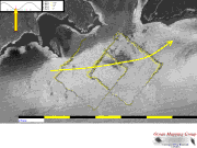
- ADCP current/backscatter imaging experiments. The Kennebecasis Sill
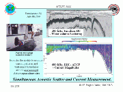
- Long Reach Cross Section - Example of multisensor acquisition
- Grand Bay Sill - M2 tidal cycle evolution of salt-water intrusions
- Grand Bay Sill - Numerical Modelling
Shippagan Bay Survey 2003 - Regional ADCP current measurements
Opportunistic MVP Operations (Examples for use in GGE5013 labs)
Last modified March 13 2012 by J.Muggah