CSL Heron

heron lens picture

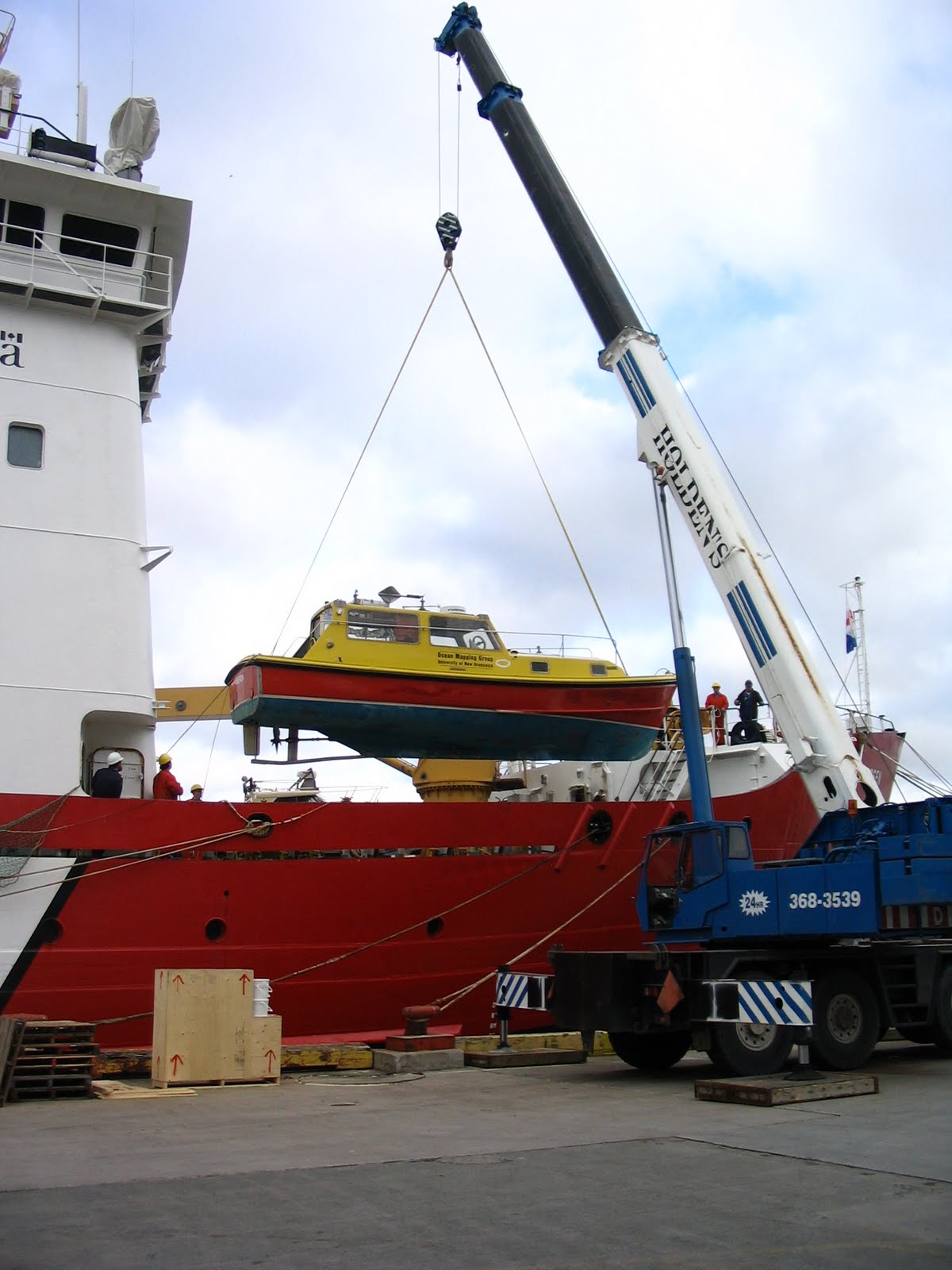
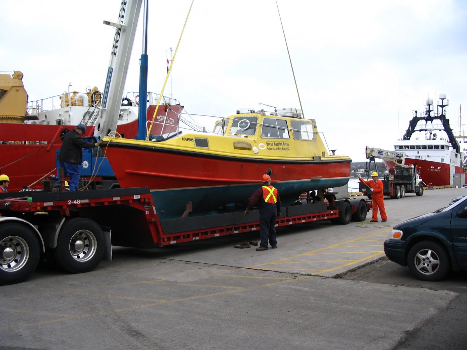
CSL Heron is a state-of-the-art 34ft hydrographic/geophysical/oceanographic survey launch. The Heron is owned by the Canadian Hydrographic Service (CHS) and is currently on loan to the Ocean Mapping Group at the University of New Brunswick (UNB). The loan is part of a Joint Partnering Agreement between the CHS and UNB. Heron is provided for the purposes of conducting Ocean Mapping related research and training.

Originally built in 1983, the Heron was professionally rebuilt and outfitted to modern standards over the winter of 2001-2002  at the Bedford Institute of Oceanography. She is equipped with a unique suite of acoustic survey instruments funded through the Canadian Foundation of Innovation, Kongsberg Simrad and ACOA. She has been used in support of a series of collaborative research projects along the Fundy Coast of New Brunswick, in the Canadian Arctic aboard the CCGS Amundsen as part of the Arctic Net program, and on the West Coast of Canada.


Table of Contents

Physical Dimension and Main Equipment

CSL Heron was built in 1983 by C&C Boatyard in Ontario based on a Nelson hull. She was was one of the first two boats (Heron and Hagdon) of the H Class, that became the mainstay of CHS single-beam launch operations in the 1980’s. The original 2 boats looked significantly different at first, with a large open cockpit and a Z-drive. Based on early trials, the current superstructure configuration was decided upon and these hulls were modified to have the current larger cabin and direct-drive shaft..

All subsequent H-Boats (a second batch were delivered in ~ 1988) were of this configuration. The Heron and Hagdon were unique in that they had Caterpillar rather than Volvo propulsion and that they had a single-support skeg mounted rudder rather than the V-skeg of the later builds. The V skegs (adopted also on the newer P-boats), are more resistant to grounding (as they are not coupled to the prop-shaft) but are far worse for maneouvering.

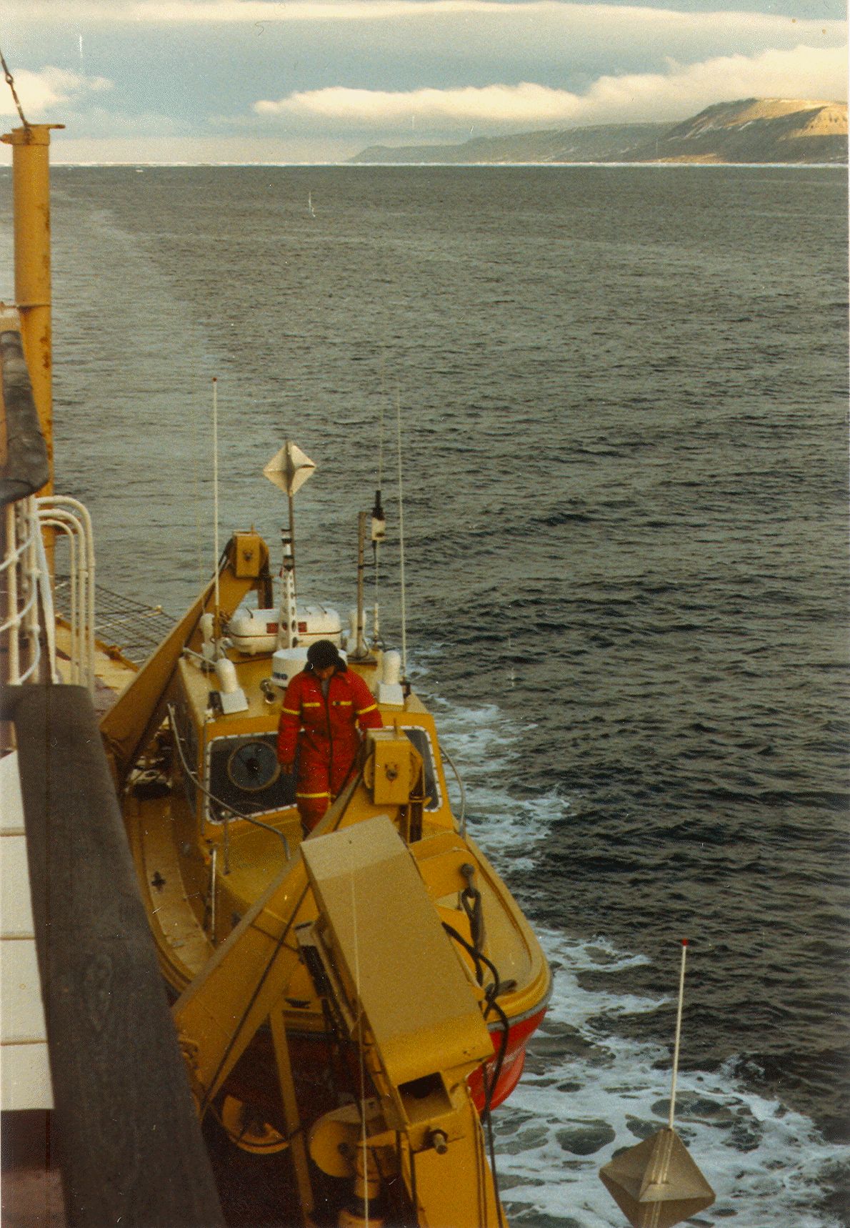
The Heron operated as single beam survey launch atttached to CSS Baffin (100m Arctic survey vessel) for operations in the Arctic and on the Grand Banks during the 1980’s. In 1989, CSS Baffin was retired and Heron was put in storage. In 1994 her engine was rebuilt for use as a demonstration boat for the  multibeam courses in St. Andrew’s in 1994/5/6. After that she was mothballed for a further 5 years, before being remobilised for this project in the fall of  2001.

Over the winter of 2005/2006 the Heron was stripped down to fibreglass and completely rebuilt at Grand Manan Boats Ltd. in Grand Manan. There was a complete replacement of all electronics (24V and 120V) aboard. A new engine and generator were purchased and installed. New AC and DC wiring was run. Hull damage was repaired. The sound proofing, headliner, and desk were replaced. A 6 ft shock mounted server rack was installed. The navigation system was upgraded to a Furuno Nav Station vx2 black box unit with sounder, WAAS enabled GPS, digital radar, and heading sensor.

  • Length10.0 m (34 ft)
  • Draft1.15m (0.85 m at transducer face)
  • Weight15,000 lbs (including full payload)

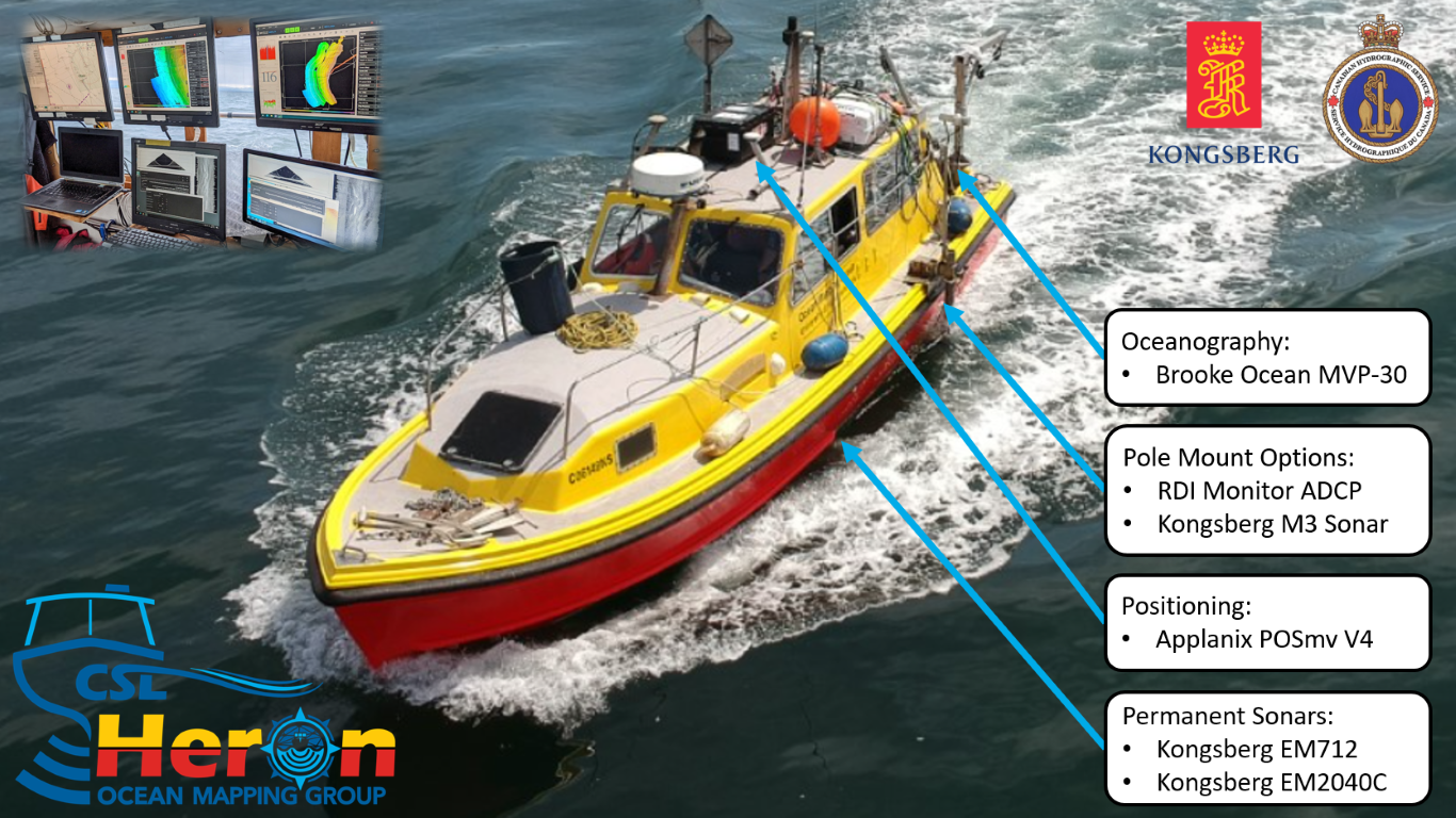
Survey Instrumentation


Home Base

CSL Heron’s main base for operations is out of the Institute of Ocean Sciences (IOS) located at:
9860 West Saanich Road,  Sidney, British Columbia, V8L 4B2, Canada.


Area of Operations 2002

areas of Heron operations 2002
  1. St. Andrews Harbour – Hydrocamp 2003
  2. Mispec Bay Sandwave Field – spring and fall surveys
  3. Blacks Point Disposal Site – pre and post dumping surveys
  4. Limekiln Bay, Letang Estuary – aquaculture site surveys
  5. Passamaquoddy Bay Pockmarks    – subbotom profiling
  6. Long Island Sound, Grand Manan  Lobster habitat surveys
  7. Duck Island Sound, Grand Manan  scallop habitat surveys
  8. Saint John River Lakes – quaternary seismic stratigraphy
  9. Grand Bay, Kennebecasis Bay  -fjord geomorphology surveys


Area of Operations 2003

Heron underwent extensive refit at the Saint John Marina over the 2002-2003 winter, including minor hull repairs. full repaint and having the 3.5 kHz transducer being fitted as a flush hull mounting. She operated from April to November.


2003 ops Completed Projects included :  

  1. Mispec Bay dunefield spring survey  (last 2 weeks of April) – fall Survey October
  2. Grand Bay, Westfield Channel – Hydrocamp 2003  (1st 3 weeks May)
  3. Blacks Point Dumpsite  NRCan pre-dumping survey – June – post-dumping November
  4. Kennebecasis Bay –Salt water intrusion experiment (last week May- all of June).
  5. Shippagan Bay, Gulf of St. Lawrence -July-August : DFO-Moncton, collaborative habitat study
  6. Upper Saint John River at Fredericton – September – undergraduate and graduate training.
  7. Long Reach Oceanographic Surveys – October and November .
  8. Saint John Harbour Approaches – November – Optical Backscatter Surveys of Dredge Spoil Plumes


Area of Operations 2004

Further internal storage chamber and repair work went on over the 2003-2004 winter. Heron was launched in April and is schedule for recovery in November


2004 ops The projects completed or underway include:  

  1. Long Reach, Lower Saint John River – Hydrocamp 2004 – May
  2. Long Reach – Salt-Fresh Mixing – Tidal Cycle Studies –  June –  September – October
  3. Evandale to Gagetown – Sturgeon Habitat Surveys – June
  4. Blacks Point Dumpsite  NRCan pre-dumping survey – July – post dumping – November
  5. Saint John Plume – MVP sections – Fundy Coast – July
  6. Fundy Isles (Deer-Island to Wolves) – Habitat Survey for SABS – August
  7. Passamaquoddy Bay – Pockmark change and subbottom profiling surveys
  8. Grand Bay – Undergraduate training -GGE 3353 – 4042-5072-5013 – September
  9. Gagetown to Fredericton – Sturgeon Habitat Surveys – October
  10. Kennebecasis Fjord Bathymetry surveys – October-November
  11. Saint John Harbour Approaches – November -Optical backscatter surveys of Dredge Spoil Plumes


Area of Operations 2005

Multibeam system upgraded to EM3002-S in July. Upgrade of PCs in preparation for Arctic work. Heron was launched in April and ended her season abruptly in Quebec City on July 29.


Completed projects:  

  1. Kennebecasis, Lower Saint John River – Multibeam & Sidescan surveys, MVP section – April, May, June.
  2. Deer Island, Passamaquoddy Bay – Habitat Survey for SABS – Hydrocamp 2005 – May
  3. Quebec City – Lady Gray wreck survey – July 28


Area of Operations 2006

Complete replacement of all electronics aboard. Engine replaced, new Kohler generator, new AC & DC wiring. Hull damage repaired. Replacement of damaged EM3002 transducer (transducer well and mount repaired). Sound proofing, headliner, desk replaced. 6 ft shock mounted server rack installed. Full Furuno Nav Station black box unit installed with sounder, WAAS enabled GPS, digital radar, and heading sensor. Rack mounted PCs and Knudsen transceivers installed.


Completed projects:  

  1. Passamaquoddy Bay, – Saint Andrews Biological Station (SABS) Mapping – Hydrocamp 2006 – June.
  2. Baie des Chaleurs – Lidar Optical Backscatter research – June, July
  3. Fundy Coast – Ocean Action Plan (OAP) Mapping – Fundy Shoreline – July, August
  4. Quebec City- Preparations for Arctic – August
  5. Canadian Arctic Archipelago- ArcticNet Project – August through November
    • Oliver Sound, Baffin Island- Fjord Mapping – Sept. 4,5
    • Belcher Glacier, Devon Island- Glacier Head Mapping – September
    • Resolute, Nunavut- Coastal Seabed Mapping – September
    • Coronation Gulf- Safety of Navigation Mapping – September
    • DeSalis Bay, Banks Island- Coastal Seabed Mapping – September
    • Sachs Harbour, Banks Island- Coastal Seabed Mapping – October
    • Tyne Bay, Cape Parry, NWT- Coastal Seabed Mapping – October
    • Beaufort Sea- OAP Mapping – October
    • Nachvak Fjord, Labrador- Coastal Seabed Mapping – November
    • Saglek Fjord, Labrador- Coastal Seabed Mapping – November
    • Voisey Bay, Labrador- Coastal Seabed Mapping – November


Area of Operations 2007


Launched at Saint John Marina May 28th. Recovered Saint John Marina September.


Completed projects:  

  1. Kennebecasis, Rijkswaterstaat Training – June
  2. Grand Manan, OAP Mapping – June & July
  3. Fredericton, – GGE Kinematic Lab – September


Area of Operations 2008

Surface sound speed sensor installed. Launched at Saint John Marina April 11. Recovered Saint John Marina November 17.


Completed projects:  

  1. Saint John Harbour, Tidal Cycle – April 22
  2. Saint John Harbour, Hydro Camp – April / May
  3. Maces Bay, OAP Mapping – May
  4. Saint John Harbour, Tidal Cycle – May 30
  5. Eastern Arctic (Baffin Island), Delta and CHS surveys – August & September
  6. Saint John Habour, Tidal Cycle – November


Area of Operations 2009

Launched at Saint John Harbour March 17. Recovered Saint John Marina June 12.

Completed projects:  

  1. Saint John Harbour, Tidal Cycle – March 26
  2. Saint John Harbour, Hydro Camp – May
  3. Blue Hill Bay & Somes Sound, Maine,, Pockmark Surveys – May 23 to June 4
  4. Passamaquoddy and Maces Bays, Site Surveys – June 8 & 9
  5. Saint John Habour, Tidal Cycle – June 11

Area of Operations 2010 – Present

  1. Squamish, British Columbia
  2. Saanich Inlet, British Columbia
  3. Fraser River, British Columbia
  4. Bute Inlet, British Columbia