
Past Operations
Area of Operations 2002
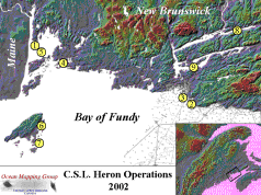
- St. Andrews Harbour – Hydrocamp 2003
- Mispec Bay Sandwave Field – spring and fall surveys
- Blacks Point Disposal Site – pre and post dumping surveys
- Limekiln Bay, Letang Estuary – aquaculture site surveys
- Passamaquoddy Bay Pockmarks – subbotom profiling
- Long Island Sound, Grand Manan Lobster habitat surveys
- Duck Island Sound, Grand Manan scallop habitat surveys
- Saint John River Lakes – quaternary seismic stratigraphy
- Grand Bay, Kennebecasis Bay -fjord geomorphology surveys
Area of Operations 2003
Heron underwent extensive refit at the Saint John Marina over the 2002-2003 winter, including minor hull repairs. full repaint and having the 3.5 kHz transducer being fitted as a flush hull mounting. She operated from April to November.
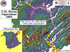
Completed Projects Included:
- Mispec Bay dunefield spring survey (last 2 weeks of April) – fall Survey October
- Grand Bay, Westfield Channel – Hydrocamp 2003 (1st 3 weeks May)
- Blacks Point Dumpsite NRCan pre-dumping survey – June – post-dumping November
- Kennebecasis Bay –Salt water intrusion experiment (last week May- all of June).
- Shippagan Bay, Gulf of St. Lawrence -July-August : DFO-Moncton, collaborative habitat study
- Upper Saint John River at Fredericton – September – undergraduate and graduate training.
- Long Reach Oceanographic Surveys – October and November.
- Saint John Harbour Approaches – November – Optical Backscatter Surveys of Dredge Spoil Plumes
Area of Operations 2004
Further internal storage chamber and repair work went on over the 2003-2004 winter. Heron was launched in April and is schedule for recovery in November.
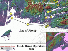
The Projects Included:
- Long Reach, Lower Saint John River – Hydrocamp 2004 – May
- Long Reach – Salt-Fresh Mixing – Tidal Cycle Studies – June – September – October
- Evandale to Gagetown – Sturgeon Habitat Surveys – June
- Blacks Point Dumpsite NRCan pre-dumping survey – July – post dumping – November
- Saint John Plume – MVP sections – Fundy Coast – July
- Fundy Isles (Deer-Island to Wolves) – Habitat Survey for SABS – August
- Passamaquoddy Bay – Pockmark change and subbottom profiling surveys
- Grand Bay – Undergraduate training -GGE 3353 – 4042-5072-5013 – September
- Gagetown to Fredericton – Sturgeon Habitat Surveys – October
- Kennebecasis Fjord Bathymetry surveys – October-November
- Saint John Harbour Approaches – November -Optical backscatter surveys of Dredge Spoil Plumes
Area of Operations 2005
Multibeam system upgraded to EM3002-S in July. Upgrade of PCs in preparation for Arctic work. Heron was launched in April and ended her season abruptly in Quebec City on July 29.
The Projects Included:
- Kennebecasis, Lower Saint John River – Multibeam & Sidescan surveys, MVP section – April, May, June.
- Deer Island, Passamaquoddy Bay – Habitat Survey for SABS – Hydrocamp 2005 – May
- Quebec City – Lady Gray wreck survey – July 28
Area of Operations 2006
Complete replacement of all electronics aboard. Engine replaced, new Kohler generator, new AC & DC wiring. Hull damage repaired. Replacement of damaged EM3002 transducer (transducer well and mount repaired). Sound proofing, headliner, desk replaced. 6 ft shock mounted server rack installed. Full Furuno Nav Station black box unit installed with sounder, WAAS enabled GPS, digital radar, and heading sensor. Rack mounted PCs and Knudsen transceivers installed.
The Projects Included:
- Passamaquoddy Bay, – Saint Andrews Biological Station (SABS) Mapping – Hydrocamp 2006 – June.
- Baie des Chaleurs – Lidar Optical Backscatter research – June, July
- Fundy Coast – Ocean Action Plan (OAP) Mapping – Fundy Shoreline – July, August
- Quebec City- Preparations for Arctic – August
- Canadian Arctic Archipelago- ArcticNet Project – August through November
- Oliver Sound, Baffin Island- Fjord Mapping – Sept. 4,5
- Belcher Glacier, Devon Island- Glacier Head Mapping – September
- Resolute, Nunavut- Coastal Seabed Mapping – September
- Coronation Gulf- Safety of Navigation Mapping – September
- DeSalis Bay, Banks Island- Coastal Seabed Mapping – September
- Sachs Harbour, Banks Island- Coastal Seabed Mapping – October
- Tyne Bay, Cape Parry, NWT- Coastal Seabed Mapping – October
- Beaufort Sea- OAP Mapping – October
- Nachvak Fjord, Labrador- Coastal Seabed Mapping – November
- Saglek Fjord, Labrador- Coastal Seabed Mapping – November
- Voisey Bay, Labrador- Coastal Seabed Mapping – November
Area of Operations 2007
Launched at Saint John Marina May 28th. Recovered Saint John Marina September.
The Projects Included:
- Kennebecasis, Rijkswaterstaat Training – June
- Grand Manan, OAP Mapping – June & July
- Fredericton, – GGE Kinematic Lab – September
Area of Operations 2008
Surface sound speed sensor installed. Launched at Saint John Marina April 11. Recovered Saint John Marina November 17.
The Projects Included:
- Saint John Harbour, Tidal Cycle – April 22
- Saint John Harbour, Hydro Camp – April / May
- Maces Bay, OAP Mapping – May
- Saint John Harbour, Tidal Cycle – May 30
- Eastern Arctic (Baffin Island), Delta and CHS surveys – August & September
- Saint John Habour, Tidal Cycle – November
Area of Operations 2009
Launched at Saint John Harbour March 17. Recovered Saint John Marina June 12.
The Projects Included:
- Saint John Harbour, Tidal Cycle – March 26
- Saint John Harbour, Hydro Camp – May
- Blue Hill Bay & Somes Sound, Maine,, Pockmark Surveys – May 23 to June 4
- Passamaquoddy and Maces Bays, Site Surveys – June 8 & 9
- Saint John Habour, Tidal Cycle – June 11